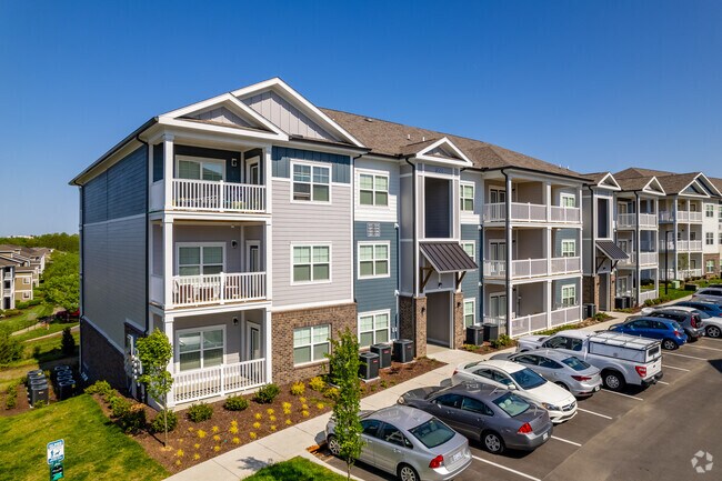
Property Record
2901 Old Franklin Rd, Antioch, TN 37013

NEARBY LISTINGS FOR SALE OR LEASE
-
-
View all Antioch listings for sale on LoopNet.com
Property Detail
2901 Old Franklin Rd
Nashville-Davidson--Murfreesboro--Franklin, TN
1St Revision Crews Crossings
163-00-0-416
PT LOT 1 CREWS CROSSINGS EASEMENT ABANDONMENT 1ST REV
Apartment
Davidson
X
Tennessee
47037C0392H
1
2025
18.24 AC
2025
Outer Southeast Nashville
015629
Nashville
27,734 SF
DEMOGRAPHICS near 2901 Old Franklin Rd
1 Mile
3 Mile
5 Mile
2024 Total Population
6,702
66,472
163,821
2029 Population
6,781
65,449
164,497
Pop Growth 2024-2029
+ 1.18%
(1.54%)
+ 0.41%
Average Age
34
34
35
2024 Total Households
2,768
24,091
58,875
HH Growth 2024-2029
+ 1.16%
(1.96%)
(0.20%)
Median Household Inc
$56,978
$61,332
$65,130
Avg Household Size
2.40
2.60
2.70
2024 Avg HH Vehicles
2.00
2.00
2.00
Median Home Value
$249,197
$261,058
$271,663
Median Year Built
2005
1996
1994
Nearby Places
Map Layers
Map Styles
 Street
 Aerial
- Restaurants
- Banks
- Shops
- Fitness
- Groceries
PUBLIC TRANSPORTATION
AIRPORT
Nashville International
DRIVE
WALK
Distance
Nashville International
14 min
7.6 mi
Freight Ports
Port of Mobile
DRIVE
WALK
Distance
Port of Mobile
491 min
446.2 mi
Nearby Properties
Address
Land Use
TOTAL SIZE
Lot Size
Zoning
Address
Land Use
TOTAL SIZE
Lot Size
Zoning
272,894 SF
36.45 AC
MULTI-ZONE
Address
Land Use
TOTAL SIZE
Lot Size
Zoning
28,908 SF
21.55 AC
MULTIZONE
Address
Land Use
TOTAL SIZE
Lot Size
Zoning
157,123 SF
12.11 AC
SCR
Address
Land Use
TOTAL SIZE
Lot Size
Zoning
129,800 SF
73.44 AC
MULTIZONE
Address
Land Use
TOTAL SIZE
Lot Size
Zoning
48,247 SF
Address
Land Use
TOTAL SIZE
Lot Size
Zoning
39,816 SF
39.02 AC
MULTIZONE
Address
Land Use
TOTAL SIZE
Lot Size
Zoning
57,362 SF
31.96 AC
MULTIZONE
Address
Land Use
TOTAL SIZE
Lot Size
Zoning
77,752 SF
13.44 AC
AR2A
Address
Land Use
TOTAL SIZE
Lot Size
Zoning
107,214 SF
13.78 AC
R10
Address
Land Use
TOTAL SIZE
Lot Size
Zoning
17,304 SF
41.35 AC
R8
Address
Land Use
TOTAL SIZE
Lot Size
Zoning
12,156 SF
122.05 AC
IR
Address
Land Use
TOTAL SIZE
Lot Size
Zoning
42,711 SF
18.42 AC
MULTIZONE
Address
Land Use
TOTAL SIZE
Lot Size
Zoning
18,707 SF
27.42 AC
RM15
Address
Land Use
TOTAL SIZE
Lot Size
Zoning
29,010 SF
16.19 AC
SP
Address
Land Use
TOTAL SIZE
Lot Size
Zoning
23,184 SF
24.15 AC
R15
Address
Land Use
TOTAL SIZE
Lot Size
Zoning
30,388 SF
29.41 AC
RM9
Address
Land Use
TOTAL SIZE
Lot Size
Zoning
100,849 SF
13.59 AC
SP
Address
Land Use
TOTAL SIZE
Lot Size
Zoning
16,726 SF
26.98 AC
R15
Address
Land Use
TOTAL SIZE
Lot Size
Zoning
23,718 SF
15 AC
MULTI-ZONE
Address
Land Use
TOTAL SIZE
Lot Size
Zoning
15,388 SF
25.28 AC
R8
Address
Land Use
TOTAL SIZE
Lot Size
Zoning
27,189 SF
13.81 AC
MULTIZONE
Address
Land Use
TOTAL SIZE
Lot Size
Zoning
18,288 SF
41.06 AC
R10
Address
Land Use
TOTAL SIZE
Lot Size
Zoning
23,580 SF
34.80 AC
RM9
Address
Land Use
TOTAL SIZE
Lot Size
Zoning
6,912 SF
47.91 AC
R10
Address
Land Use
TOTAL SIZE
Lot Size
Zoning
25,260 SF
33.29 AC
MULTIZONE
Address
Land Use
TOTAL SIZE
Lot Size
Zoning
48,405 SF
16.72 AC
MULTI-ZONE
Address
Land Use
TOTAL SIZE
Lot Size
Zoning
32,898 SF
15.14 AC
MULTIZONE
Address
Land Use
TOTAL SIZE
Lot Size
Zoning
28,187 SF
14 AC
SP
Address
Land Use
TOTAL SIZE
Lot Size
Zoning
3,994 SF
29.93 AC
RM15
The World's #1 Commercial Real Estate Marketplace
Connect with us
© 2025 CoStar Group
The information above has been obtained from sources believed reliable. While we do not doubt its accuracy we have not verified it and make no guarantee, warranty or representation about it. It is your responsibility to independently confirm its accuracy and completeness. Any projections, opinions, assumptions, or estimates used are for example only and do not represent the current or future performance of the property. The value of this transaction to you depends on tax and other factors which should be evaluated by your tax, financial, and legal advisors. You and your advisors should conduct a careful, independent investigation of the property to determine to your satisfaction the suitability of the property for your needs.