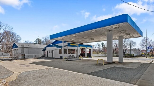
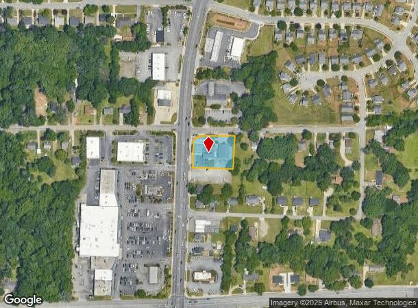
Property Record
2901 Randleman Rd, Greensboro, NC 27406

NEARBY LISTINGS FOR SALE OR LEASE
Property Detail
2901 Randleman Rd
Greensboro-High Point, NC
Coltrane Lake
0055157
CITGO/RANDLEMAN RD LO:3-6 &1-2PT PL:14-64
Commercialnec
Guilford
X
North Carolina
3710786200J
3-6
2024
0.65 AC
2025
South Greensboro
012804
Greensboro/Winston-Salem
4,824 SF
DEMOGRAPHICS near 2901 Randleman Rd
1 Mile
3 Mile
5 Mile
2024 Total Population
10,582
51,126
135,313
2029 Population
10,483
50,879
135,353
Pop Growth 2024-2029
(0.94%)
(0.48%)
+ 0.03%
Average Age
37
37
36
2024 Total Households
4,460
20,625
51,711
HH Growth 2024-2029
(0.99%)
(0.48%)
+ 0.17%
Median Household Inc
$47,582
$44,897
$46,647
Avg Household Size
2.30
2.40
2.20
2024 Avg HH Vehicles
2.00
2.00
2.00
Median Home Value
$120,220
$125,146
$156,208
Median Year Built
1985
1980
1977
Nearby Places
- Restaurants
- Banks
- Shops
- Fitness
- Groceries
PUBLIC TRANSPORTATION
COMMUTER RAIL
Greensboro Station (Piedmont - North Carolina by Train (NC Train))
DRIVE
WALK
Distance
Greensboro Station (Piedmont - North Carolina by Train (NC Train))
7 min
4.2 mi
AIRPORT
Piedmont Triad International
DRIVE
WALK
Distance
Piedmont Triad International
21 min
11.9 mi
Freight Ports
Port of Wilmington
DRIVE
WALK
Distance
Port of Wilmington
242 min
211.5 mi
Nearby Properties
Address
Land Use
TOTAL SIZE
Lot Size
Zoning
Address
Land Use
TOTAL SIZE
Lot Size
Zoning
957,290 SF
18.71 AC
C-H
Address
Land Use
TOTAL SIZE
Lot Size
Zoning
570,402 SF
33.42 AC
RM-18
Address
Land Use
TOTAL SIZE
Lot Size
Zoning
446,318 SF
125.67 AC
LI
Address
Land Use
TOTAL SIZE
Lot Size
Zoning
412,479 SF
19.68 AC
RM-26
Address
Land Use
TOTAL SIZE
Lot Size
Zoning
252,351 SF
9.48 AC
RM-18
Address
Land Use
TOTAL SIZE
Lot Size
Zoning
300,901 SF
20.39 AC
RM-18
Address
Land Use
TOTAL SIZE
Lot Size
Zoning
182,499 SF
6.74 AC
O
Address
Land Use
TOTAL SIZE
Lot Size
Zoning
280,200 SF
19.28 AC
RM-12
Address
Land Use
TOTAL SIZE
Lot Size
Zoning
116,713 SF
4.53 AC
C-M
Address
Land Use
TOTAL SIZE
Lot Size
Zoning
211,723 SF
20.24 AC
RM-18
Address
Land Use
TOTAL SIZE
Lot Size
Zoning
582,543 SF
47.07 AC
C-M
Address
Land Use
TOTAL SIZE
Lot Size
Zoning
250,084 SF
5.46 AC
PI
Address
Land Use
TOTAL SIZE
Lot Size
Zoning
336,760 SF
55.13 AC
LI
Address
Land Use
TOTAL SIZE
Lot Size
Zoning
201,999 SF
22.18 AC
C-H
Address
Land Use
TOTAL SIZE
Lot Size
Zoning
188,976 SF
41.46 AC
R-5
Address
Land Use
TOTAL SIZE
Lot Size
Zoning
168,572 SF
11.94 AC
LI
Address
Land Use
TOTAL SIZE
Lot Size
Zoning
223,912 SF
23.25 AC
O
Address
Land Use
TOTAL SIZE
Lot Size
Zoning
172,950 SF
11.49 AC
RM-18
Address
Land Use
TOTAL SIZE
Lot Size
Zoning
90,450 SF
3.15 AC
C-M
Address
Land Use
TOTAL SIZE
Lot Size
Zoning
118,707 SF
15.94 AC
C-H
Address
Land Use
TOTAL SIZE
Lot Size
Zoning
107,867 SF
14.75 AC
RM-8
Address
Land Use
TOTAL SIZE
Lot Size
Zoning
214,062 SF
9.99 AC
LI
Address
Land Use
TOTAL SIZE
Lot Size
Zoning
14,562 SF
103.79 AC
PI
Address
Land Use
TOTAL SIZE
Lot Size
Zoning
111,810 SF
5.88 AC
O
Address
Land Use
TOTAL SIZE
Lot Size
Zoning
112,758 SF
10.96 AC
RM-12
Address
Land Use
TOTAL SIZE
Lot Size
Zoning
141,098 SF
8.59 AC
RM-18
Address
Land Use
TOTAL SIZE
Lot Size
Zoning
81,260 SF
6.61 AC
CU-GO-H
Address
Land Use
TOTAL SIZE
Lot Size
Zoning
158,500 SF
17.35 AC
RM-12
Address
Land Use
TOTAL SIZE
Lot Size
Zoning
184,330 SF
10.92 AC
RM-12
Address
Land Use
TOTAL SIZE
Lot Size
Zoning
130,317 SF
11.81 AC
C-H
The World's #1 Commercial Real Estate Marketplace
Connect with us
© 2025 CoStar Group
The information above has been obtained from sources believed reliable. While we do not doubt its accuracy we have not verified it and make no guarantee, warranty or representation about it. It is your responsibility to independently confirm its accuracy and completeness. Any projections, opinions, assumptions, or estimates used are for example only and do not represent the current or future performance of the property. The value of this transaction to you depends on tax and other factors which should be evaluated by your tax, financial, and legal advisors. You and your advisors should conduct a careful, independent investigation of the property to determine to your satisfaction the suitability of the property for your needs.