Property Record
2901 S County Rd W, Odessa, TX 79766
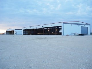

Property Detail
2901 S County Rd W
42450-00480-00000
T-2-S BLK 42 SEC 40 (CARD #11) 20.94 ACRES IN SW PART
Commercialnec
ECTOR
ES1
Texas
B and X Area of moderate flood hazard, usually the area between the limits of the 100-year and 500-year floods.
20.94 AC
2025
Midland & Odessa
2025
Other Market Areas
003003
Odessa, TX
1,600 SF
NEARBY LISTINGS FOR SALE OR LEASE
DEMOGRAPHICS near 2901 S County Rd W
1 mile
3 mile
5 mile
2025 Total Population
9,675
66,428
115,938
2030 Population
10,300
70,476
123,559
Pop Growth 2025-2030
+ 6.46%
+ 6.09%
+ 6.57%
Average Age
36
35
35
2025 Total Households
3,554
23,523
41,584
HH Growth 2025-2030
+ 7.68%
+ 7.27%
+ 7.75%
Median Household Inc
$55,648
$63,594
$64,461
Avg Household Size
2.60
2.70
2.70
2025 Avg HH Vehicles
2.00
2.00
2.00
Median Home Value
$148,430
$154,176
$172,543
Median Year Built
1973
1966
1974
Nearby Places
Map Layers
Map Styles
 Street
 Aerial
Layers
 Traffic
 Biking
Places
Listings with unknown addresses are not visible on the map
- Restaurants
- Banks
- Shops
- Fitness
- Groceries
PUBLIC TRANSPORTATION
AIRPORT
Midland International Air And Space Port
Drive
Walk
Distance
Midland International Air And Space Port
21 min
15.4 mi
Freight Ports
Port of Corpus Christi
Drive
Walk
Distance
Port of Corpus Christi
498 min
481.3 mi
Nearby Properties
Address
Land Use
TOTAL SIZE
Lot Size
Zoning
Address
Land Use
TOTAL SIZE
Lot Size
Zoning
170,241 SF
16.56 AC
EB6
Address
Land Use
TOTAL SIZE
Lot Size
Zoning
57,566 SF
Address
Land Use
TOTAL SIZE
Lot Size
Zoning
117,725 SF
19.23 AC
EE5
Address
Land Use
TOTAL SIZE
Lot Size
Zoning
30,600 SF
4.51 AC
EB6
Address
Land Use
TOTAL SIZE
Lot Size
Zoning
232,969 SF
19.81 AC
EB7
Address
Land Use
TOTAL SIZE
Lot Size
Zoning
22,470 SF
2.07 AC
EB6
Address
Land Use
TOTAL SIZE
Lot Size
Zoning
111,278 SF
28.53 AC
EB6
Address
Land Use
TOTAL SIZE
Lot Size
Zoning
99,244 SF
4.66 AC
EE1
Address
Land Use
TOTAL SIZE
Lot Size
Zoning
214,832 SF
10.42 AC
EB5
Address
Land Use
TOTAL SIZE
Lot Size
Zoning
65,175 SF
4.68 AC
EE1
Address
Land Use
TOTAL SIZE
Lot Size
Zoning
36,648 SF
86.41 AC
ES1
Address
Land Use
TOTAL SIZE
Lot Size
Zoning
25,560 SF
1.52 AC
EB6
Address
Land Use
TOTAL SIZE
Lot Size
Zoning
11,600 SF
28.47 AC
ES1
Address
Land Use
TOTAL SIZE
Lot Size
Zoning
57,566 SF
3.94 AC
EE1
Address
Land Use
TOTAL SIZE
Lot Size
Zoning
4,836 SF
4.68 AC
EE1
Address
Land Use
TOTAL SIZE
Lot Size
Zoning
72,624 SF
2.28 AC
ES1
Address
Land Use
TOTAL SIZE
Lot Size
Zoning
78,447 SF
10.93 AC
EE1
Address
Land Use
TOTAL SIZE
Lot Size
Zoning
153,754 SF
9.57 AC
EE5
Address
Land Use
TOTAL SIZE
Lot Size
Zoning
5,826 SF
32.11 AC
ES1
Address
Land Use
TOTAL SIZE
Lot Size
Zoning
40,896 SF
Address
Land Use
TOTAL SIZE
Lot Size
Zoning
17,000 SF
10.29 AC
ES1
Address
Land Use
TOTAL SIZE
Lot Size
Zoning
61,570 SF
6.44 AC
ES1
Address
Land Use
TOTAL SIZE
Lot Size
Zoning
138,064 SF
8.50 AC
EE5
Address
Land Use
TOTAL SIZE
Lot Size
Zoning
27,350 SF
30.13 AC
EB7
Address
Land Use
TOTAL SIZE
Lot Size
Zoning
3,141 SF
2.92 AC
EB7
Address
Land Use
TOTAL SIZE
Lot Size
Zoning
15,200 SF
29.64 AC
ES1
Address
Land Use
TOTAL SIZE
Lot Size
Zoning
9,754 SF
14.89 AC
ES1
Address
Land Use
TOTAL SIZE
Lot Size
Zoning
47,000 SF
17.51 AC
EB7
Address
Land Use
TOTAL SIZE
Lot Size
Zoning
50,816 SF
10.73 AC
EB7
Address
Land Use
TOTAL SIZE
Lot Size
Zoning
2,592 SF
61.28 AC
ES1
The World's #1 Commercial Real Estate Marketplace
Connect with us
© 2026 CoStar Group
The information above has been obtained from sources believed reliable. While we do not doubt its accuracy we have not verified it and make no guarantee, warranty or representation about it. It is your responsibility to independently confirm its accuracy and completeness. Any projections, opinions, assumptions, or estimates used are for example only and do not represent the current or future performance of the property. The value of this transaction to you depends on tax and other factors which should be evaluated by your tax, financial, and legal advisors. You and your advisors should conduct a careful, independent investigation of the property to determine to your satisfaction the suitability of the property for your needs.