Property Record
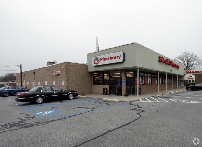
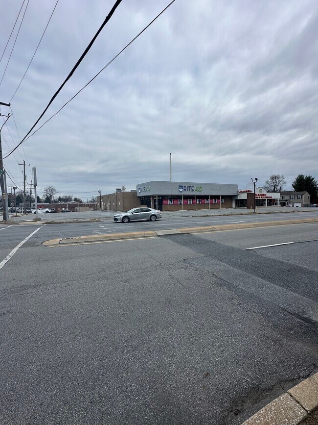
2901 Springfield Rd, Broomall, PA 19008
Current Lease Availabilities
NEARBY LISTINGS FOR SALE OR LEASE
Property Detail
2901 Springfield Rd
25-00-02464-02
GROUND 84 X 168 X IRR
Parkinglot
Delaware
X
Pennsylvania
42045C0101F
0.39 AC
2024
Delaware County
2025
Philadelphia
408001
Philadelphia-Camden-Wilmington, PA-NJ-DE-MD
DEMOGRAPHICS near 2901 Springfield Rd
1 mile
3 mile
5 mile
2024 Total Population
14,221
61,759
223,865
2029 Population
14,272
61,547
223,316
Pop Growth 2024-2029
+ 0.36%
(0.34%)
(0.25%)
Average Age
45
44
41
2024 Total Households
5,760
23,412
82,608
HH Growth 2024-2029
+ 0.82%
(0.15%)
(0.22%)
Median Household Inc
$108,982
$126,595
$113,892
Avg Household Size
2.40
2.60
2.50
2024 Avg HH Vehicles
2.00
2.00
2.00
Median Home Value
$403,788
$457,704
$415,951
Median Year Built
1959
1961
1956
Nearby Places
Map Layers
Map Styles
 Street
 Aerial
Transit
 Traffic
 Biking
Places
Listings with unknown addresses are not visible on the map
- Restaurants
- Banks
- Shops
- Fitness
- Groceries
PUBLIC TRANSPORTATION
COMMUTER RAIL
Haverford (R5 - Southeastern Pennsylvania Transportation Authority Regional Rail (SEPTA Regional Rail))
Drive
Walk
Distance
Haverford (R5 - Southeastern Pennsylvania Transportation Authority Regional Rail (SEPTA Regional Rail))
13 min
5.4 mi
Bryn Mawr (R5 - Southeastern Pennsylvania Transportation Authority Regional Rail (SEPTA Regional Rail))
Drive
Walk
Distance
Bryn Mawr (R5 - Southeastern Pennsylvania Transportation Authority Regional Rail (SEPTA Regional Rail))
14 min
6.2 mi
AIRPORT
Philadelphia International
Drive
Walk
Distance
Philadelphia International
27 min
16.3 mi
Trenton Mercer
Drive
Walk
Distance
Trenton Mercer
65 min
47.8 mi
Freight Ports
South Jersey Port
Drive
Walk
Distance
South Jersey Port
35 min
16.5 mi
Nearby Properties
Address
Land Use
TOTAL SIZE
Lot Size
Zoning
Address
Land Use
TOTAL SIZE
Lot Size
Zoning
227,940 SF
110.24 AC
Address
Land Use
TOTAL SIZE
Lot Size
Zoning
259,200 SF
21.14 AC
Address
Land Use
TOTAL SIZE
Lot Size
Zoning
45,294 SF
83.20 AC
Address
Land Use
TOTAL SIZE
Lot Size
Zoning
59,126 SF
84.57 AC
Address
Land Use
TOTAL SIZE
Lot Size
Zoning
60,768 SF
16.17 AC
Address
Land Use
TOTAL SIZE
Lot Size
Zoning
26.47 AC
Address
Land Use
TOTAL SIZE
Lot Size
Zoning
73,059 SF
10.17 AC
Address
Land Use
TOTAL SIZE
Lot Size
Zoning
308,248 SF
52 AC
Address
Land Use
TOTAL SIZE
Lot Size
Zoning
90,784 SF
26.26 AC
Address
Land Use
TOTAL SIZE
Lot Size
Zoning
264,399 SF
122.05 AC
Address
Land Use
TOTAL SIZE
Lot Size
Zoning
23,868 SF
11.18 AC
Address
Land Use
TOTAL SIZE
Lot Size
Zoning
185,720 SF
0.50 AC
Address
Land Use
TOTAL SIZE
Lot Size
Zoning
238,024 SF
3.07 AC
Address
Land Use
TOTAL SIZE
Lot Size
Zoning
168,474 SF
1 AC
Address
Land Use
TOTAL SIZE
Lot Size
Zoning
30,204 SF
13.75 AC
Address
Land Use
TOTAL SIZE
Lot Size
Zoning
131,102 SF
5.95 AC
Address
Land Use
TOTAL SIZE
Lot Size
Zoning
114,058 SF
3.20 AC
Address
Land Use
TOTAL SIZE
Lot Size
Zoning
261,618 SF
30.57 AC
Address
Land Use
TOTAL SIZE
Lot Size
Zoning
93,068 SF
12.47 AC
Address
Land Use
TOTAL SIZE
Lot Size
Zoning
331,021 SF
35.19 AC
Address
Land Use
TOTAL SIZE
Lot Size
Zoning
69,420 SF
17.12 AC
Address
Land Use
TOTAL SIZE
Lot Size
Zoning
26,999 SF
21 AC
Address
Land Use
TOTAL SIZE
Lot Size
Zoning
Address
Land Use
TOTAL SIZE
Lot Size
Zoning
38,220 SF
22.05 AC
Address
Land Use
TOTAL SIZE
Lot Size
Zoning
72,564 SF
24.44 AC
Address
Land Use
TOTAL SIZE
Lot Size
Zoning
126,812 SF
10.09 AC
Address
Land Use
TOTAL SIZE
Lot Size
Zoning
140,426 SF
10.46 AC
Address
Land Use
TOTAL SIZE
Lot Size
Zoning
100,242 SF
5 AC
Address
Land Use
TOTAL SIZE
Lot Size
Zoning
90,368 SF
124 AC
Address
Land Use
TOTAL SIZE
Lot Size
Zoning
88,056 SF
10.98 AC
The World's #1 Commercial Real Estate Marketplace
Connect with us
© 2026 CoStar Group
The information above has been obtained from sources believed reliable. While we do not doubt its accuracy we have not verified it and make no guarantee, warranty or representation about it. It is your responsibility to independently confirm its accuracy and completeness. Any projections, opinions, assumptions, or estimates used are for example only and do not represent the current or future performance of the property. The value of this transaction to you depends on tax and other factors which should be evaluated by your tax, financial, and legal advisors. You and your advisors should conduct a careful, independent investigation of the property to determine to your satisfaction the suitability of the property for your needs.