Property Record
2901 Thurman St, Laredo, TX 78046
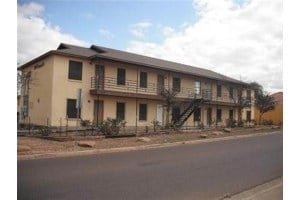

Property Detail
2901 Thurman St
180074
LOTS 1,2,3 & 4 BLK 1753 ED
Multifamilydwelling
Webb
R2
Texas
B and X Area of moderate flood hazard, usually the area between the limits of the 100-year and 500-year floods.
1-4
2024
0.89 AC
2025
Texas South Area
000108
Other Market Areas
22,520 SF
Laredo, TX
NEARBY LISTINGS FOR SALE OR LEASE
-
-
-
No Photo
-
View all Laredo listings for sale on LoopNet.com
DEMOGRAPHICS near 2901 Thurman St
1 mile
3 mile
5 mile
2025 Total Population
20,501
94,553
157,450
2030 Population
20,866
97,217
161,421
Pop Growth 2025-2030
+ 1.78%
+ 2.82%
+ 2.52%
Average Age
32
32
34
2025 Total Households
5,380
25,377
45,104
HH Growth 2025-2030
+ 1.88%
+ 2.94%
+ 2.60%
Median Household Inc
$46,199
$55,063
$49,598
Avg Household Size
3.70
3.60
3.40
2025 Avg HH Vehicles
2.00
2.00
2.00
Median Home Value
$178,931
$171,589
$166,821
Median Year Built
1998
1999
1992
Nearby Places
Map Layers
Map Styles
 Street
 Aerial
Transit
 Traffic
 Biking
Places
Listings with unknown addresses are not visible on the map
- Restaurants
- Banks
- Shops
- Fitness
- Groceries
PUBLIC TRANSPORTATION
AIRPORT
Laredo International
Drive
Walk
Distance
Laredo International
15 min
6.7 mi
SALE & LEASE HISTORY
LISTING DATE
SALE/LEASE

Nov 26, 2024
For Sale
Nearby Properties
Address
Land Use
TOTAL SIZE
Lot Size
Zoning
Address
Land Use
TOTAL SIZE
Lot Size
Zoning
423,977 SF
1.27 AC
R2
Address
Land Use
TOTAL SIZE
Lot Size
Zoning
318,944 SF
59.72 AC
R1A
Address
Land Use
TOTAL SIZE
Lot Size
Zoning
310,346 SF
87.65 AC
R1A
Address
Land Use
TOTAL SIZE
Lot Size
Zoning
347,773 SF
49.74 AC
R1
Address
Land Use
TOTAL SIZE
Lot Size
Zoning
165,608 SF
28.50 AC
R2
Address
Land Use
TOTAL SIZE
Lot Size
Zoning
231,146 SF
1.77 AC
R1
Address
Land Use
TOTAL SIZE
Lot Size
Zoning
178,302 SF
45.97 AC
R3
Address
Land Use
TOTAL SIZE
Lot Size
Zoning
380,420 SF
9.18 AC
B3
Address
Land Use
TOTAL SIZE
Lot Size
Zoning
169,339 SF
28 AC
Address
Land Use
TOTAL SIZE
Lot Size
Zoning
138,494 SF
50 AC
R1A
Address
Land Use
TOTAL SIZE
Lot Size
Zoning
137,182 SF
9.67 AC
R1
Address
Land Use
TOTAL SIZE
Lot Size
Zoning
118,165 SF
14 AC
Address
Land Use
TOTAL SIZE
Lot Size
Zoning
108,994 SF
15.39 AC
Address
Land Use
TOTAL SIZE
Lot Size
Zoning
119,908 SF
11.03 AC
Address
Land Use
TOTAL SIZE
Lot Size
Zoning
101,034 SF
20 AC
R1A
Address
Land Use
TOTAL SIZE
Lot Size
Zoning
107,824 SF
13.38 AC
R1
Address
Land Use
TOTAL SIZE
Lot Size
Zoning
102,815 SF
2.23 AC
Address
Land Use
TOTAL SIZE
Lot Size
Zoning
98,447 SF
20 AC
R1A
Address
Land Use
TOTAL SIZE
Lot Size
Zoning
95,769 SF
10 AC
R1
Address
Land Use
TOTAL SIZE
Lot Size
Zoning
79,764 SF
30 AC
R1
Address
Land Use
TOTAL SIZE
Lot Size
Zoning
136,195 SF
9.50 AC
Address
Land Use
TOTAL SIZE
Lot Size
Zoning
87,789 SF
10.70 AC
Address
Land Use
TOTAL SIZE
Lot Size
Zoning
90,400 SF
1.77 AC
R3
Address
Land Use
TOTAL SIZE
Lot Size
Zoning
82,328 SF
5.12 AC
R3
Address
Land Use
TOTAL SIZE
Lot Size
Zoning
214,365 SF
18.11 AC
R2
Address
Land Use
TOTAL SIZE
Lot Size
Zoning
77,788 SF
19.67 AC
Address
Land Use
TOTAL SIZE
Lot Size
Zoning
55,094 SF
44.55 AC
B3
Address
Land Use
TOTAL SIZE
Lot Size
Zoning
164,360 SF
7.49 AC
R1
Address
Land Use
TOTAL SIZE
Lot Size
Zoning
72,897 SF
8 AC
R1
Address
Land Use
TOTAL SIZE
Lot Size
Zoning
57,690 SF
8.98 AC
B4
The World's #1 Commercial Real Estate Marketplace
Connect with us
© 2026 CoStar Group
The information above has been obtained from sources believed reliable. While we do not doubt its accuracy we have not verified it and make no guarantee, warranty or representation about it. It is your responsibility to independently confirm its accuracy and completeness. Any projections, opinions, assumptions, or estimates used are for example only and do not represent the current or future performance of the property. The value of this transaction to you depends on tax and other factors which should be evaluated by your tax, financial, and legal advisors. You and your advisors should conduct a careful, independent investigation of the property to determine to your satisfaction the suitability of the property for your needs.