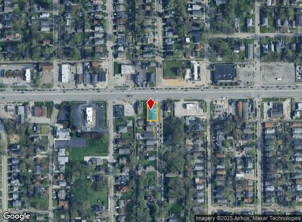
Property Record
2901 W 16Th St, Indianapolis, IN 46222
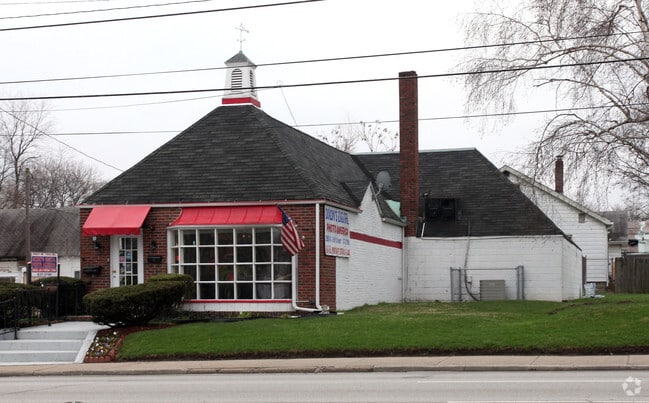
This Property Is For Sale
NEARBY LISTINGS FOR SALE OR LEASE
Property Detail
2901 W 16Th St
Indianapolis-Carmel-Anderson, IN
Stouts Haughville Add 130.7Ft N End E 1/
49-06-33-153-133.000-901
STOUTS HAUGHVILLE ADD 130.7FT N END E 1/2E 1/2 L201
Commercialnec
Marion
X
Indiana
18097C0137G
201
2023
0.18 AC
2024
Speedway
341200
Indianapolis
4,536 SF
DEMOGRAPHICS near 2901 W 16Th St
1 Mile
3 Mile
5 Mile
2024 Total Population
16,941
103,235
280,929
2029 Population
17,187
104,097
281,710
Pop Growth 2024-2029
+ 1.45%
+ 0.83%
+ 0.28%
Average Age
35
35
35
2024 Total Households
6,403
42,718
116,631
HH Growth 2024-2029
+ 1.51%
+ 0.96%
+ 0.37%
Median Household Inc
$44,215
$48,791
$52,754
Avg Household Size
2.50
2.30
2.30
2024 Avg HH Vehicles
2.00
2.00
2.00
Median Home Value
$81,266
$117,292
$170,855
Median Year Built
1953
1957
1962
Nearby Places
- Restaurants
- Banks
- Shops
- Fitness
- Groceries
PUBLIC TRANSPORTATION
COMMUTER RAIL
Indianapolis (Cardinal - Amtrak)
DRIVE
WALK
Distance
Indianapolis (Cardinal - Amtrak)
8 min
4.2 mi
AIRPORT
Indianapolis International
DRIVE
WALK
Distance
Indianapolis International
24 min
12.7 mi
Freight Ports
Port of Toledo
DRIVE
WALK
Distance
Port of Toledo
273 min
226.3 mi
Nearby Properties
Address
Land Use
TOTAL SIZE
Lot Size
Zoning
Address
Land Use
TOTAL SIZE
Lot Size
Zoning
1,381,492 SF
15.08 AC
ZO01
Address
Land Use
TOTAL SIZE
Lot Size
Zoning
546,391 SF
4.38 AC
ZO01
Address
Land Use
TOTAL SIZE
Lot Size
Zoning
23,200 SF
1.71 AC
Address
Land Use
TOTAL SIZE
Lot Size
Zoning
19,176 SF
28.36 AC
ZO01
Address
Land Use
TOTAL SIZE
Lot Size
Zoning
19,536 SF
4.05 AC
ZO01
Address
Land Use
TOTAL SIZE
Lot Size
Zoning
83,966 SF
2.30 AC
ZO01
Address
Land Use
TOTAL SIZE
Lot Size
Zoning
2,273 SF
1.52 AC
ZO01
Address
Land Use
TOTAL SIZE
Lot Size
Zoning
12,392 SF
0.99 AC
ZO01
Address
Land Use
TOTAL SIZE
Lot Size
Zoning
44,485 SF
0.76 AC
ZO01
Address
Land Use
TOTAL SIZE
Lot Size
Zoning
170,000 SF
4.05 AC
ZO01
Address
Land Use
TOTAL SIZE
Lot Size
Zoning
20,422 SF
0.42 AC
ZO01
Address
Land Use
TOTAL SIZE
Lot Size
Zoning
12.63 AC
ZO01
Address
Land Use
TOTAL SIZE
Lot Size
Zoning
384,520 SF
1.93 AC
ZO01
Address
Land Use
TOTAL SIZE
Lot Size
Zoning
123,373 SF
2.14 AC
ZO01
Address
Land Use
TOTAL SIZE
Lot Size
Zoning
5,200 SF
2.43 AC
ZO01
Address
Land Use
TOTAL SIZE
Lot Size
Zoning
36,000 SF
0.94 AC
ZO01
Address
Land Use
TOTAL SIZE
Lot Size
Zoning
40,205 SF
1.58 AC
Address
Land Use
TOTAL SIZE
Lot Size
Zoning
11,775 SF
0.44 AC
ZO01
Address
Land Use
TOTAL SIZE
Lot Size
Zoning
2,674 SF
3.05 AC
ZO01
Address
Land Use
TOTAL SIZE
Lot Size
Zoning
11,230 SF
0.53 AC
ZO02
Address
Land Use
TOTAL SIZE
Lot Size
Zoning
80,249 SF
71.96 AC
ZO01
Address
Land Use
TOTAL SIZE
Lot Size
Zoning
73,803 SF
0.93 AC
Address
Land Use
TOTAL SIZE
Lot Size
Zoning
17,250 SF
0.29 AC
ZO01
Address
Land Use
TOTAL SIZE
Lot Size
Zoning
111,238 SF
0.06 AC
ZO01
Address
Land Use
TOTAL SIZE
Lot Size
Zoning
176,017 SF
3.92 AC
ZO01
Address
Land Use
TOTAL SIZE
Lot Size
Zoning
271,411 SF
3 AC
ZO01
Address
Land Use
TOTAL SIZE
Lot Size
Zoning
1,260 SF
3.92 AC
ZO01
Address
Land Use
TOTAL SIZE
Lot Size
Zoning
67,783 SF
44.97 AC
ZO01
Address
Land Use
TOTAL SIZE
Lot Size
Zoning
31,920 SF
0.80 AC
Address
Land Use
TOTAL SIZE
Lot Size
Zoning
3,013 SF
10.80 AC
ZO01
The World's #1 Commercial Real Estate Marketplace
Connect with us
© 2025 CoStar Group
The information above has been obtained from sources believed reliable. While we do not doubt its accuracy we have not verified it and make no guarantee, warranty or representation about it. It is your responsibility to independently confirm its accuracy and completeness. Any projections, opinions, assumptions, or estimates used are for example only and do not represent the current or future performance of the property. The value of this transaction to you depends on tax and other factors which should be evaluated by your tax, financial, and legal advisors. You and your advisors should conduct a careful, independent investigation of the property to determine to your satisfaction the suitability of the property for your needs.