Property Record
2901 Youngstown Rd, Turlock, CA 95380

This Property Is For Sale
NEARBY LISTINGS FOR SALE OR LEASE
Property Detail
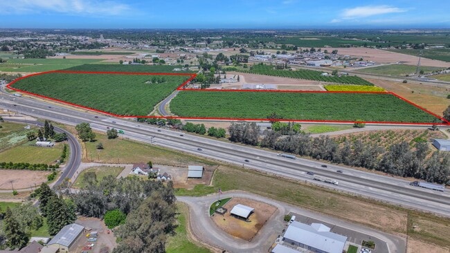
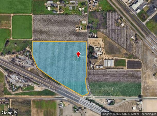
2901 Youngstown Rd
Modesto, CA
Youngstown Colony
044-33-05
YOUNGSTOWN COLONY LOT 9,10
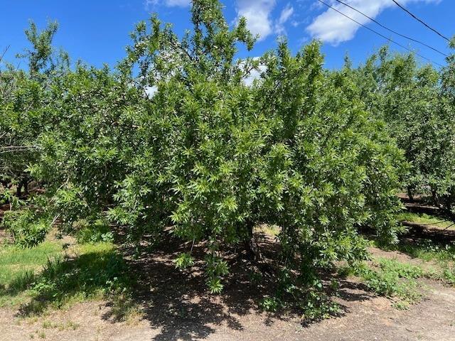
Orchard
Stanislaus
X
California
06047C0175G
9&10
2025
29.72 AC
2025
Turlock/SW Stanislaus
003700
Stockton/Modesto
1,527 SF
DEMOGRAPHICS near 2901 Youngstown Rd
1 mile
3 mile
5 mile
2024 Total Population
1,148
32,214
94,854
2029 Population
1,148
32,320
96,076
Pop Growth 2024-2029
0.00%
+ 0.33%
+ 1.29%
Average Age
37
36
37
2024 Total Households
330
10,250
30,959
HH Growth 2024-2029
0.00%
+ 0.34%
+ 1.23%
Median Household Inc
$78,889
$60,489
$70,188
Avg Household Size
3.40
3.00
2.90
2024 Avg HH Vehicles
3.00
2.00
2.00
Median Home Value
$395,832
$377,352
$390,654
Median Year Built
1983
1972
1982
Nearby Places
Map Layers
Map Styles
 Street
 Aerial
Transit
 Traffic
 Biking
Places
Listings with unknown addresses are not visible on the map
- Restaurants
- Banks
- Shops
- Fitness
- Groceries
PUBLIC TRANSPORTATION
COMMUTER RAIL
Turlock-Denair (San Joaquins - Amtrak)
Drive
Walk
Distance
Turlock-Denair (San Joaquins - Amtrak)
13 min
7.9 mi
Freight Ports
Port of Stockton
Drive
Walk
Distance
Port of Stockton
63 min
49.8 mi
Nearby Properties
Address
Land Use
TOTAL SIZE
Lot Size
Zoning
Address
Land Use
TOTAL SIZE
Lot Size
Zoning
128,000 SF
6.48 AC
Address
Land Use
TOTAL SIZE
Lot Size
Zoning
81,953 SF
5 AC
M2
Address
Land Use
TOTAL SIZE
Lot Size
Zoning
112,779 SF
7.35 AC
TURCC
Address
Land Use
TOTAL SIZE
Lot Size
Zoning
57,788 SF
1.08 AC
TURPD
Address
Land Use
TOTAL SIZE
Lot Size
Zoning
69,842 SF
2.54 AC
TURRH
Address
Land Use
TOTAL SIZE
Lot Size
Zoning
78.67 AC
Address
Land Use
TOTAL SIZE
Lot Size
Zoning
42,096 SF
3.17 AC
Address
Land Use
TOTAL SIZE
Lot Size
Zoning
160,603 SF
11.17 AC
Address
Land Use
TOTAL SIZE
Lot Size
Zoning
57,674 SF
4 AC
Address
Land Use
TOTAL SIZE
Lot Size
Zoning
47,197 SF
1.59 AC
TURPD
Address
Land Use
TOTAL SIZE
Lot Size
Zoning
38,600 SF
3.29 AC
Address
Land Use
TOTAL SIZE
Lot Size
Zoning
143.68 AC
A1
Address
Land Use
TOTAL SIZE
Lot Size
Zoning
28,254 SF
2.15 AC
Address
Land Use
TOTAL SIZE
Lot Size
Zoning
8.69 AC
A240
Address
Land Use
TOTAL SIZE
Lot Size
Zoning
19.58 AC
Address
Land Use
TOTAL SIZE
Lot Size
Zoning
32,500 SF
2.31 AC
Address
Land Use
TOTAL SIZE
Lot Size
Zoning
48,664 SF
4.13 AC
Address
Land Use
TOTAL SIZE
Lot Size
Zoning
1,086 SF
51.80 AC
A1
Address
Land Use
TOTAL SIZE
Lot Size
Zoning
18 AC
A1
Address
Land Use
TOTAL SIZE
Lot Size
Zoning
1,440 SF
82.20 AC
A1
Address
Land Use
TOTAL SIZE
Lot Size
Zoning
25,129 SF
2.40 AC
Address
Land Use
TOTAL SIZE
Lot Size
Zoning
19,990 SF
5.02 AC
Address
Land Use
TOTAL SIZE
Lot Size
Zoning
34,882 SF
1.04 AC
TURPD
Address
Land Use
TOTAL SIZE
Lot Size
Zoning
15,125 SF
0.94 AC
Address
Land Use
TOTAL SIZE
Lot Size
Zoning
25,550 SF
2.25 AC
Address
Land Use
TOTAL SIZE
Lot Size
Zoning
45,394 SF
3.86 AC
Address
Land Use
TOTAL SIZE
Lot Size
Zoning
25,200 SF
1.91 AC
Address
Land Use
TOTAL SIZE
Lot Size
Zoning
23,424 SF
1.86 AC
Address
Land Use
TOTAL SIZE
Lot Size
Zoning
154,922 SF
4.16 AC
PD
Address
Land Use
TOTAL SIZE
Lot Size
Zoning
165,414 SF
6.37 AC
The World's #1 Commercial Real Estate Marketplace
Connect with us
© 2026 CoStar Group
The information above has been obtained from sources believed reliable. While we do not doubt its accuracy we have not verified it and make no guarantee, warranty or representation about it. It is your responsibility to independently confirm its accuracy and completeness. Any projections, opinions, assumptions, or estimates used are for example only and do not represent the current or future performance of the property. The value of this transaction to you depends on tax and other factors which should be evaluated by your tax, financial, and legal advisors. You and your advisors should conduct a careful, independent investigation of the property to determine to your satisfaction the suitability of the property for your needs.