Property Record
2902 E 30Th Ave, Apache Junction, AZ 85119
Property Detail
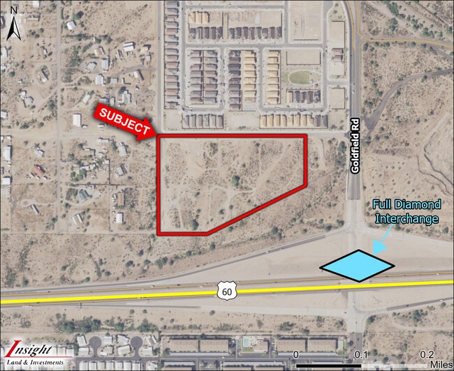
2902 E 30Th Ave
103-23-032A
SE NW SE NE OF SEC 34-1N-8E LESS A TRIANG PCL IN S1/2 1.98 AC
Vacantlandnec
PINAL
UNDESIGNAT
Arizona
B and X Area of moderate flood hazard, usually the area between the limits of the 100-year and 500-year floods.
1.98 AC
2024
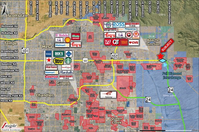
Superstition Corridor
2025
Phoenix
000324
Phoenix-Mesa-Chandler, AZ
3,600 SF
NEARBY LISTINGS FOR SALE OR LEASE
DEMOGRAPHICS near 2902 E 30Th Ave
1 mile
3 mile
5 mile
2024 Total Population
9,016
30,052
75,310
2029 Population
11,557
37,883
92,865
Pop Growth 2024-2029
+ 28.18%
+ 26.06%
+ 23.31%
Average Age
53
49
51
2024 Total Households
4,195
13,304
34,194
HH Growth 2024-2029
+ 28.01%
+ 25.71%
+ 23.25%
Median Household Inc
$62,495
$65,277
$61,621
Avg Household Size
2.10
2.20
2.20
2024 Avg HH Vehicles
2.00
2.00
2.00
Median Home Value
$144,013
$280,813
$291,056
Median Year Built
1997
1994
1995
Nearby Places
Map Layers
Map Styles
 Street
 Aerial
Transit
 Traffic
 Biking
Places
Listings with unknown addresses are not visible on the map
- Restaurants
- Banks
- Shops
- Fitness
- Groceries
PUBLIC TRANSPORTATION
AIRPORT
Phoenix-Mesa Gateway
Drive
Walk
Distance
Phoenix-Mesa Gateway
26 min
16.9 mi
Phoenix Sky Harbor International
Drive
Walk
Distance
Phoenix Sky Harbor International
43 min
32.8 mi
Freight Ports
Port of San Diego
Drive
Walk
Distance
Port of San Diego
430 min
389.5 mi
SALE & LEASE HISTORY
LISTING DATE
SALE/LEASE

Jul 25, 2023
For Sale
Nearby Properties
Address
Land Use
TOTAL SIZE
Lot Size
Zoning
Address
Land Use
TOTAL SIZE
Lot Size
Zoning
117,169 SF
13.27 AC
Address
Land Use
TOTAL SIZE
Lot Size
Zoning
Address
Land Use
TOTAL SIZE
Lot Size
Zoning
128,905 SF
7.14 AC
UNDESIGNAT
Address
Land Use
TOTAL SIZE
Lot Size
Zoning
Address
Land Use
TOTAL SIZE
Lot Size
Zoning
Address
Land Use
TOTAL SIZE
Lot Size
Zoning
126,549 SF
9.75 AC
Address
Land Use
TOTAL SIZE
Lot Size
Zoning
81,523 SF
12.08 AC
CB1
Address
Land Use
TOTAL SIZE
Lot Size
Zoning
108,644 SF
10.12 AC
UNDESIGNAT
Address
Land Use
TOTAL SIZE
Lot Size
Zoning
62,290 SF
7.53 AC
UNDESIGNAT
Address
Land Use
TOTAL SIZE
Lot Size
Zoning
54,706 SF
16.20 AC
UNDESIGNAT
Address
Land Use
TOTAL SIZE
Lot Size
Zoning
30,775 SF
7.60 AC
UNDESIGNAT
Address
Land Use
TOTAL SIZE
Lot Size
Zoning
102,430 SF
5 AC
UNDESIGNAT
Address
Land Use
TOTAL SIZE
Lot Size
Zoning
26,022 SF
11.03 AC
UNDESIGNAT
Address
Land Use
TOTAL SIZE
Lot Size
Zoning
54,300 SF
4.57 AC
UNDESIGNAT
Address
Land Use
TOTAL SIZE
Lot Size
Zoning
683 SF
36.74 AC
UNDESIGNAT
Address
Land Use
TOTAL SIZE
Lot Size
Zoning
24,158 SF
5.19 AC
Address
Land Use
TOTAL SIZE
Lot Size
Zoning
28,800 SF
4.59 AC
Address
Land Use
TOTAL SIZE
Lot Size
Zoning
20,967 SF
3.60 AC
UNDESIGNAT
Address
Land Use
TOTAL SIZE
Lot Size
Zoning
34,441 SF
4.62 AC
UNDESIGNAT
Address
Land Use
TOTAL SIZE
Lot Size
Zoning
21,547 SF
4.25 AC
UNDESIGNAT
Address
Land Use
TOTAL SIZE
Lot Size
Zoning
19,977 SF
2.93 AC
UNDESIGNAT
Address
Land Use
TOTAL SIZE
Lot Size
Zoning
19,754 SF
11.67 AC
UNDESIGNAT
Address
Land Use
TOTAL SIZE
Lot Size
Zoning
560 SF
27.95 AC
UNDESIGNAT
Address
Land Use
TOTAL SIZE
Lot Size
Zoning
26,586 SF
4.51 AC
Address
Land Use
TOTAL SIZE
Lot Size
Zoning
20,123 SF
1 AC
UNDESIGNAT
Address
Land Use
TOTAL SIZE
Lot Size
Zoning
163 SF
32.90 AC
MHP
Address
Land Use
TOTAL SIZE
Lot Size
Zoning
77,730 SF
6.15 AC
Address
Land Use
TOTAL SIZE
Lot Size
Zoning
22,860 SF
5 AC
CI1
Address
Land Use
TOTAL SIZE
Lot Size
Zoning
9,540 SF
19.37 AC
RVP
The World's #1 Commercial Real Estate Marketplace
Connect with us
© 2026 CoStar Group
The information above has been obtained from sources believed reliable. While we do not doubt its accuracy we have not verified it and make no guarantee, warranty or representation about it. It is your responsibility to independently confirm its accuracy and completeness. Any projections, opinions, assumptions, or estimates used are for example only and do not represent the current or future performance of the property. The value of this transaction to you depends on tax and other factors which should be evaluated by your tax, financial, and legal advisors. You and your advisors should conduct a careful, independent investigation of the property to determine to your satisfaction the suitability of the property for your needs.