Property Record
2902 E 46Th St, Indianapolis, IN 46205
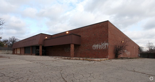


Property Detail
2902 E 46Th St
49-07-08-129-005.000-801
PT SW1/4 S8 T16 R4 BEG 1020.76 W OF SE COR P.O.B. W404 NE380.18 E225.7 S307.33 TO BEG 2.199 AC (1.493 TAX)
Commercialacreage
Marion
ZO01
Indiana
B and X Area of moderate flood hazard, usually the area between the limits of the 100-year and 500-year floods.
2.20 AC
2024
Lawrence/East County
2025
Indianapolis
321600
Indianapolis-Carmel-Greenwood, IN
NEARBY LISTINGS FOR SALE OR LEASE
DEMOGRAPHICS near 2902 E 46Th St
1 mile
3 mile
5 mile
2025 Total Population
8,300
103,670
255,973
2030 Population
8,433
105,767
262,307
Pop Growth 2025-2030
+ 1.60%
+ 2.02%
+ 2.47%
Average Age
38
38
38
2025 Total Households
4,085
45,188
111,434
HH Growth 2025-2030
+ 1.54%
+ 1.91%
+ 2.43%
Median Household Inc
$54,202
$65,976
$65,195
Avg Household Size
2.00
2.20
2.20
2025 Avg HH Vehicles
1.00
2.00
2.00
Median Home Value
$237,656
$292,893
$283,062
Median Year Built
1962
1955
1957
Nearby Places
Map Layers
Map Styles
 Street
 Aerial
Layers
 Traffic
 Biking
Places
Listings with unknown addresses are not visible on the map
- Restaurants
- Banks
- Shops
- Fitness
- Groceries
PUBLIC TRANSPORTATION
COMMUTER RAIL
Drive
Walk
Distance
15 min
7.6 mi
AIRPORT
Indianapolis International
Drive
Walk
Distance
Indianapolis International
36 min
20.6 mi
Nearby Properties
Address
Land Use
TOTAL SIZE
Lot Size
Zoning
Address
Land Use
TOTAL SIZE
Lot Size
Zoning
143,890 SF
37.81 AC
ZO01
Address
Land Use
TOTAL SIZE
Lot Size
Zoning
866 SF
14.33 AC
ZO01
Address
Land Use
TOTAL SIZE
Lot Size
Zoning
76,657 SF
8.85 AC
ZO01
Address
Land Use
TOTAL SIZE
Lot Size
Zoning
207,800 SF
2.23 AC
ZO01
Address
Land Use
TOTAL SIZE
Lot Size
Zoning
25,340 SF
8.57 AC
ZO01
Address
Land Use
TOTAL SIZE
Lot Size
Zoning
2,142 SF
9.91 AC
ZO01
Address
Land Use
TOTAL SIZE
Lot Size
Zoning
3,200 SF
3.51 AC
ZO01
Address
Land Use
TOTAL SIZE
Lot Size
Zoning
13,789 SF
3.93 AC
ZO01
Address
Land Use
TOTAL SIZE
Lot Size
Zoning
2,156 SF
0.46 AC
ZO01
Address
Land Use
TOTAL SIZE
Lot Size
Zoning
2,313 SF
35.45 AC
ZO01
Address
Land Use
TOTAL SIZE
Lot Size
Zoning
98,790 SF
0.18 AC
ZO01
Address
Land Use
TOTAL SIZE
Lot Size
Zoning
5,670 SF
25.69 AC
Address
Land Use
TOTAL SIZE
Lot Size
Zoning
2.81 AC
ZO01
Address
Land Use
TOTAL SIZE
Lot Size
Zoning
7,740 SF
2.04 AC
ZO01
Address
Land Use
TOTAL SIZE
Lot Size
Zoning
1,903 SF
20.77 AC
ZO01
Address
Land Use
TOTAL SIZE
Lot Size
Zoning
1,528 SF
15.64 AC
ZO01
Address
Land Use
TOTAL SIZE
Lot Size
Zoning
98,160 SF
0.65 AC
ZO01
Address
Land Use
TOTAL SIZE
Lot Size
Zoning
17,621 SF
3.20 AC
ZO01
Address
Land Use
TOTAL SIZE
Lot Size
Zoning
17,469 SF
0.87 AC
ZO01
Address
Land Use
TOTAL SIZE
Lot Size
Zoning
2,951 SF
15.45 AC
ZO01
Address
Land Use
TOTAL SIZE
Lot Size
Zoning
66,953 SF
10.87 AC
ZO01
Address
Land Use
TOTAL SIZE
Lot Size
Zoning
1,551 SF
1.23 AC
ZO01
Address
Land Use
TOTAL SIZE
Lot Size
Zoning
29,624 SF
2.56 AC
ZO01
Address
Land Use
TOTAL SIZE
Lot Size
Zoning
2,927 SF
8.75 AC
ZO01
Address
Land Use
TOTAL SIZE
Lot Size
Zoning
188,212 SF
28.51 AC
Address
Land Use
TOTAL SIZE
Lot Size
Zoning
16,650 SF
1.56 AC
ZO01
Address
Land Use
TOTAL SIZE
Lot Size
Zoning
4,692 SF
25.76 AC
Address
Land Use
TOTAL SIZE
Lot Size
Zoning
32,522 SF
0.78 AC
ZO01
Address
Land Use
TOTAL SIZE
Lot Size
Zoning
20,590 SF
0.77 AC
ZO01
Address
Land Use
TOTAL SIZE
Lot Size
Zoning
41,632 SF
9.17 AC
ZO01
The World's #1 Commercial Real Estate Marketplace
Connect with us
© 2026 CoStar Group
The information above has been obtained from sources believed reliable. While we do not doubt its accuracy we have not verified it and make no guarantee, warranty or representation about it. It is your responsibility to independently confirm its accuracy and completeness. Any projections, opinions, assumptions, or estimates used are for example only and do not represent the current or future performance of the property. The value of this transaction to you depends on tax and other factors which should be evaluated by your tax, financial, and legal advisors. You and your advisors should conduct a careful, independent investigation of the property to determine to your satisfaction the suitability of the property for your needs.