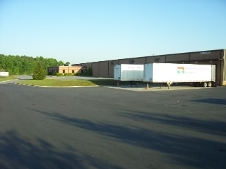
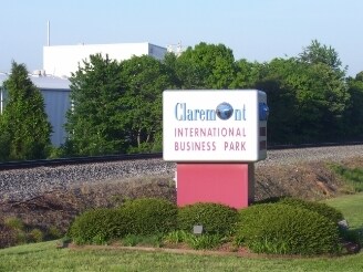
Property Record
2902 Kelly Blvd, Claremont, NC 28610


NEARBY LISTINGS FOR SALE OR LEASE
Property Detail
2902 Kelly Blvd
3751129605880000
M H B P C Inc
Officebuilding
PLAT 32-1
X
Catawba
3710375100J
North Carolina
2024
8.07 AC
2025
Catawba County
011401
Charlotte
101,012 SF
Hickory-Lenoir-Morganton, NC
DEMOGRAPHICS near 2902 Kelly Blvd
1 Mile
3 Mile
5 Mile
2024 Total Population
941
11,537
35,313
2029 Population
985
12,034
36,861
Pop Growth 2024-2029
+ 4.68%
+ 4.31%
+ 4.38%
Average Age
41
42
41
2024 Total Households
359
4,564
14,027
HH Growth 2024-2029
+ 4.74%
+ 4.25%
+ 4.32%
Median Household Inc
$45,312
$57,907
$55,349
Avg Household Size
2.50
2.50
2.40
2024 Avg HH Vehicles
2.00
2.00
2.00
Median Home Value
$181,954
$202,090
$179,357
Median Year Built
1983
1985
1984
Nearby Places
Map Layers
Map Styles
 Street
 Aerial
- Restaurants
- Banks
- Shops
- Fitness
- Groceries
PUBLIC TRANSPORTATION
AIRPORT
Concord-Padgett Regional
DRIVE
WALK
Distance
Concord-Padgett Regional
67 min
48.3 mi
SALE & LEASE HISTORY
LISTING DATE
SALE/LEASE

Aug 05, 2024
For Lease
Nearby Properties
Address
Land Use
TOTAL SIZE
Lot Size
Zoning
Address
Land Use
TOTAL SIZE
Lot Size
Zoning
368,024 SF
69.40 AC
M-1
Address
Land Use
TOTAL SIZE
Lot Size
Zoning
157,777 SF
25.42 AC
M-1
Address
Land Use
TOTAL SIZE
Lot Size
Zoning
101,781 SF
25.77 AC
M-1
Address
Land Use
TOTAL SIZE
Lot Size
Zoning
301,737 SF
45.71 AC
M-1
Address
Land Use
TOTAL SIZE
Lot Size
Zoning
67,806 SF
27.40 AC
M-1
Address
Land Use
TOTAL SIZE
Lot Size
Zoning
82,274 SF
19.77 AC
M-1-CD
Address
Land Use
TOTAL SIZE
Lot Size
Zoning
398,044 SF
17.89 AC
M-1
Address
Land Use
TOTAL SIZE
Lot Size
Zoning
23,646 SF
79.60 AC
M-1
Address
Land Use
TOTAL SIZE
Lot Size
Zoning
9,064 SF
4.59 AC
B-2-CD
Address
Land Use
TOTAL SIZE
Lot Size
Zoning
283,942 SF
26.59 AC
M-1
Address
Land Use
TOTAL SIZE
Lot Size
Zoning
270,125 SF
19.98 AC
EM-1
Address
Land Use
TOTAL SIZE
Lot Size
Zoning
226,704 SF
24.60 AC
EM-1
Address
Land Use
TOTAL SIZE
Lot Size
Zoning
155,824 SF
27.77 AC
M-1
Address
Land Use
TOTAL SIZE
Lot Size
Zoning
14,702 SF
363.28 AC
R-20
Address
Land Use
TOTAL SIZE
Lot Size
Zoning
213,422 SF
33.51 AC
M-1
Address
Land Use
TOTAL SIZE
Lot Size
Zoning
637,521 SF
87.22 AC
M-1
Address
Land Use
TOTAL SIZE
Lot Size
Zoning
318,757 SF
23.50 AC
M-1
Address
Land Use
TOTAL SIZE
Lot Size
Zoning
156,161 SF
17.22 AC
M-1
Address
Land Use
TOTAL SIZE
Lot Size
Zoning
14.87 AC
B-2
Address
Land Use
TOTAL SIZE
Lot Size
Zoning
206,696 SF
10.24 AC
M-1
Address
Land Use
TOTAL SIZE
Lot Size
Zoning
31,936 SF
46.87 AC
M-1
Address
Land Use
TOTAL SIZE
Lot Size
Zoning
249,849 SF
20.99 AC
M-1
Address
Land Use
TOTAL SIZE
Lot Size
Zoning
104,493 SF
7.37 AC
M-1
Address
Land Use
TOTAL SIZE
Lot Size
Zoning
47,490 SF
34.43 AC
EM-1-CD
Address
Land Use
TOTAL SIZE
Lot Size
Zoning
467,211 SF
23.01 AC
M-1
Address
Land Use
TOTAL SIZE
Lot Size
Zoning
12,032 SF
12.15 AC
B-2
Address
Land Use
TOTAL SIZE
Lot Size
Zoning
49,109 SF
19.39 AC
B-2
Address
Land Use
TOTAL SIZE
Lot Size
Zoning
21.85 AC
R-20
Address
Land Use
TOTAL SIZE
Lot Size
Zoning
128,840 SF
9.13 AC
EM-1
Address
Land Use
TOTAL SIZE
Lot Size
Zoning
51,408 SF
9.26 AC
M-1
The World's #1 Commercial Real Estate Marketplace
Connect with us
© 2026 CoStar Group
The information above has been obtained from sources believed reliable. While we do not doubt its accuracy we have not verified it and make no guarantee, warranty or representation about it. It is your responsibility to independently confirm its accuracy and completeness. Any projections, opinions, assumptions, or estimates used are for example only and do not represent the current or future performance of the property. The value of this transaction to you depends on tax and other factors which should be evaluated by your tax, financial, and legal advisors. You and your advisors should conduct a careful, independent investigation of the property to determine to your satisfaction the suitability of the property for your needs.