Property Record
2902 S Atlantic Ave, Cocoa Beach, FL 32931
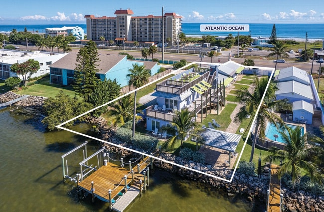
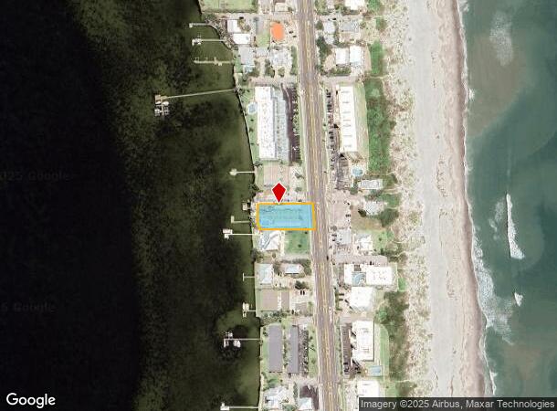
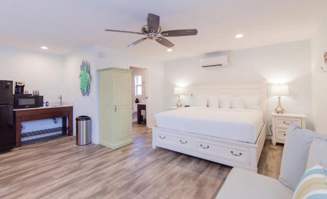
This Property Is For Sale
NEARBY LISTINGS FOR SALE OR LEASE
-
-
View all Cocoa Beach listings for sale on LoopNet.com
Property Detail
2902 S Atlantic Ave
Palm Bay-Melbourne-Titusville, FL
Crescent Beach
25-37-26-50-0000G.0-0009.00
CRESCENT BEACH LOTS 9 TO 12 & CLOSED ST ON W BLK G
Motel
Brevard
AE
Florida
12009C0463H
9
2024
0.46 AC
2025
Titusville/Cocoa Beach
068101
Orlando
7,042 SF
DEMOGRAPHICS near 2902 S Atlantic Ave
1 Mile
3 Mile
5 Mile
2024 Total Population
1,899
6,527
22,702
2029 Population
2,133
7,267
25,366
Pop Growth 2024-2029
+ 12.32%
+ 11.34%
+ 11.73%
Average Age
52
50
52
2024 Total Households
947
3,278
11,111
HH Growth 2024-2029
+ 12.35%
+ 11.35%
+ 12.11%
Median Household Inc
$95,231
$81,833
$86,966
Avg Household Size
2.00
2.00
2.00
2024 Avg HH Vehicles
2.00
2.00
2.00
Median Home Value
$583,556
$433,456
$433,291
Median Year Built
1982
1978
1978
Nearby Places
Map Layers
Map Styles
 Street
 Aerial
- Restaurants
- Banks
- Shops
- Fitness
- Groceries
PUBLIC TRANSPORTATION
AIRPORT
Melbourne Orlando International
DRIVE
WALK
Distance
Melbourne Orlando International
34 min
17.1 mi
Nearby Properties
Address
Land Use
TOTAL SIZE
Lot Size
Zoning
Address
Land Use
TOTAL SIZE
Lot Size
Zoning
48,367 SF
197.18 AC
PS1
Address
Land Use
TOTAL SIZE
Lot Size
Zoning
226.81 AC
GU
Address
Land Use
TOTAL SIZE
Lot Size
Zoning
112.19 AC
Address
Land Use
TOTAL SIZE
Lot Size
Zoning
27,663 SF
1.54 AC
CN
Address
Land Use
TOTAL SIZE
Lot Size
Zoning
43,105 SF
1.55 AC
RM1
Address
Land Use
TOTAL SIZE
Lot Size
Zoning
19,288 SF
2.24 AC
RS1
Address
Land Use
TOTAL SIZE
Lot Size
Zoning
56,050 SF
11.96 AC
PS1
Address
Land Use
TOTAL SIZE
Lot Size
Zoning
37,096 SF
1.03 AC
RM1
Address
Land Use
TOTAL SIZE
Lot Size
Zoning
23,512 SF
1.25 AC
PS1
Address
Land Use
TOTAL SIZE
Lot Size
Zoning
9,350 SF
0.34 AC
RU230
Address
Land Use
TOTAL SIZE
Lot Size
Zoning
39,104 SF
2.34 AC
BU1
Address
Land Use
TOTAL SIZE
Lot Size
Zoning
33,425 SF
1.91 AC
RM1
Address
Land Use
TOTAL SIZE
Lot Size
Zoning
9,289 SF
0.25 AC
CG
Address
Land Use
TOTAL SIZE
Lot Size
Zoning
647 SF
1.67 AC
B1
Address
Land Use
TOTAL SIZE
Lot Size
Zoning
5,177 SF
0.29 AC
RM2
Address
Land Use
TOTAL SIZE
Lot Size
Zoning
4,842 SF
0.58 AC
RS1
Address
Land Use
TOTAL SIZE
Lot Size
Zoning
9,952 SF
0.84 AC
RU230
Address
Land Use
TOTAL SIZE
Lot Size
Zoning
13,637 SF
0.42 AC
CN
Address
Land Use
TOTAL SIZE
Lot Size
Zoning
6,300 SF
0.58 AC
RM2
Address
Land Use
TOTAL SIZE
Lot Size
Zoning
13,780 SF
0.43 AC
RM1
Address
Land Use
TOTAL SIZE
Lot Size
Zoning
7,100 SF
0.32 AC
CG
Address
Land Use
TOTAL SIZE
Lot Size
Zoning
18,986 SF
2.95 AC
PS1
Address
Land Use
TOTAL SIZE
Lot Size
Zoning
13,777 SF
3.75 AC
RS1
Address
Land Use
TOTAL SIZE
Lot Size
Zoning
13,112 SF
0.56 AC
RU215
Address
Land Use
TOTAL SIZE
Lot Size
Zoning
6,839 SF
1.14 AC
RU230
Address
Land Use
TOTAL SIZE
Lot Size
Zoning
11,149 SF
2.44 AC
BU1
Address
Land Use
TOTAL SIZE
Lot Size
Zoning
8,656 SF
0.70 AC
RU215
Address
Land Use
TOTAL SIZE
Lot Size
Zoning
0.58 AC
RS1
Address
Land Use
TOTAL SIZE
Lot Size
Zoning
0.58 AC
RS1
The World's #1 Commercial Real Estate Marketplace
Connect with us
© 2026 CoStar Group
The information above has been obtained from sources believed reliable. While we do not doubt its accuracy we have not verified it and make no guarantee, warranty or representation about it. It is your responsibility to independently confirm its accuracy and completeness. Any projections, opinions, assumptions, or estimates used are for example only and do not represent the current or future performance of the property. The value of this transaction to you depends on tax and other factors which should be evaluated by your tax, financial, and legal advisors. You and your advisors should conduct a careful, independent investigation of the property to determine to your satisfaction the suitability of the property for your needs.