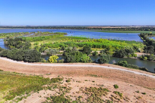
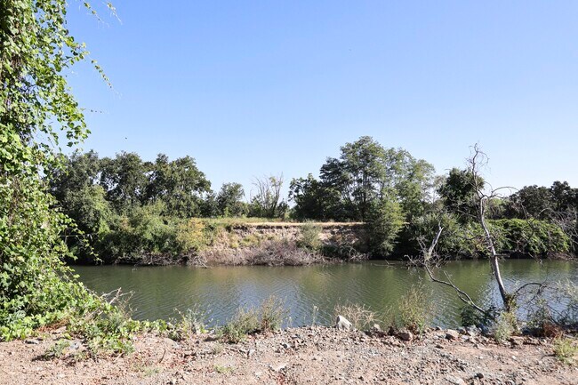
Property Record
29021 N Vail Rd, Thornton, CA 95686

Property Detail
29021 N Vail Rd
Farms
SAN JOAQUIN
AG40
California
AE The base floodplain where base flood elevations are provided. AE Zones are now used on new format FIRMs instead of A1-A30 Zones.
82.97 AC
2025
Lodi
2025
Stockton/Modesto
004001
Stockton-Lodi, CA
1,131 SF
001-090-03
NEARBY LISTINGS FOR SALE OR LEASE
DEMOGRAPHICS near 29021 N Vail Rd
1 mile
3 mile
5 mile
2025 Total Population
3
1,904
2,686
2030 Population
3
1,809
2,565
Pop Growth 2025-2030
0.00%
(4.99%)
(4.50%)
Average Age
0
42
41
2025 Total Households
1
680
880
HH Growth 2025-2030
0.00%
(5.15%)
(5.00%)
Median Household Inc
$0
$64,579
$66,011
Avg Household Size
.00
2.70
2.70
2025 Avg HH Vehicles
.00
2.00
2.00
Median Home Value
$0
$687,500
$687,500
Median Year Built
1984
1967
1968
Nearby Places
Map Layers
Map Styles
 Street
 Aerial
Layers
 Traffic
 Biking
Places
Listings with unknown addresses are not visible on the map
- Restaurants
- Banks
- Shops
- Fitness
- Groceries
PUBLIC TRANSPORTATION
AIRPORT
Stockton Metro
Drive
Walk
Distance
Stockton Metro
45 min
31.7 mi
Freight Ports
Port of Stockton
Drive
Walk
Distance
Port of Stockton
35 min
24.2 mi
SALE & LEASE HISTORY
LISTING DATE
SALE/LEASE

Sep 20, 2023
For Sale
Nearby Properties
Address
Land Use
TOTAL SIZE
Lot Size
Zoning
Address
Land Use
TOTAL SIZE
Lot Size
Zoning
9.07 AC
AG40
Address
Land Use
TOTAL SIZE
Lot Size
Zoning
1,687 SF
658.77 AC
AG40
Address
Land Use
TOTAL SIZE
Lot Size
Zoning
9,360 SF
25.32 AC
AG-80
Address
Land Use
TOTAL SIZE
Lot Size
Zoning
952 SF
147.51 AC
AG40
Address
Land Use
TOTAL SIZE
Lot Size
Zoning
237.77 AC
AG40
Address
Land Use
TOTAL SIZE
Lot Size
Zoning
806 SF
2.37 AC
Address
Land Use
TOTAL SIZE
Lot Size
Zoning
205.29 AC
AG40
Address
Land Use
TOTAL SIZE
Lot Size
Zoning
416 AC
AG40
Address
Land Use
TOTAL SIZE
Lot Size
Zoning
1,747 SF
40 AC
AG40
Address
Land Use
TOTAL SIZE
Lot Size
Zoning
80.43 AC
AG-80
Address
Land Use
TOTAL SIZE
Lot Size
Zoning
3,472 SF
1.89 AC
CC
Address
Land Use
TOTAL SIZE
Lot Size
Zoning
56,352 SF
9.66 AC
M-2 AG-80
Address
Land Use
TOTAL SIZE
Lot Size
Zoning
74.50 AC
AG40
Address
Land Use
TOTAL SIZE
Lot Size
Zoning
4.52 AC
M-2
Address
Land Use
TOTAL SIZE
Lot Size
Zoning
209.44 AC
AG-80
Address
Land Use
TOTAL SIZE
Lot Size
Zoning
121.84 AC
AG-80
Address
Land Use
TOTAL SIZE
Lot Size
Zoning
658 SF
24.88 AC
AG40
Address
Land Use
TOTAL SIZE
Lot Size
Zoning
1,548 SF
39.45 AC
AG-20
Address
Land Use
TOTAL SIZE
Lot Size
Zoning
329.85 AC
AG-80
Address
Land Use
TOTAL SIZE
Lot Size
Zoning
2,065 SF
52.62 AC
AG40
Address
Land Use
TOTAL SIZE
Lot Size
Zoning
40 AC
AG40
Address
Land Use
TOTAL SIZE
Lot Size
Zoning
512 SF
4.03 AC
AG40
Address
Land Use
TOTAL SIZE
Lot Size
Zoning
4,457 SF
15.18 AC
AG40
Address
Land Use
TOTAL SIZE
Lot Size
Zoning
11.55 AC
CFS
Address
Land Use
TOTAL SIZE
Lot Size
Zoning
1,172 SF
51.58 AC
AG40
Address
Land Use
TOTAL SIZE
Lot Size
Zoning
190.50 AC
AG-80 O
Address
Land Use
TOTAL SIZE
Lot Size
Zoning
29,280 SF
5.10 AC
M-2 AG-20
Address
Land Use
TOTAL SIZE
Lot Size
Zoning
1,062 SF
52.81 AC
AG40
Address
Land Use
TOTAL SIZE
Lot Size
Zoning
12.37 AC
CFS
The World's #1 Commercial Real Estate Marketplace
Connect with us
© 2026 CoStar Group
The information above has been obtained from sources believed reliable. While we do not doubt its accuracy we have not verified it and make no guarantee, warranty or representation about it. It is your responsibility to independently confirm its accuracy and completeness. Any projections, opinions, assumptions, or estimates used are for example only and do not represent the current or future performance of the property. The value of this transaction to you depends on tax and other factors which should be evaluated by your tax, financial, and legal advisors. You and your advisors should conduct a careful, independent investigation of the property to determine to your satisfaction the suitability of the property for your needs.