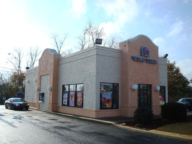
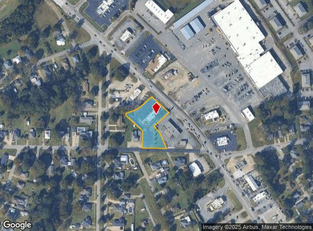
Property Record
2903 20Th Ave, Valley, AL 36854
NEARBY LISTINGS FOR SALE OR LEASE
Property Detail
2903 20Th Ave
17-01-01-1-001-003.002
BEG AT NW COR OF LOT 5-A, RUN NE'LY122.6' TO 20TH AVENUE, SE'LY ALONG AVENUE 150', SW'LY132.42', SE'LY53.27', SE'LY113.96' TO
Restaurantdrivein
Chambers
X
Alabama
13285C0310F
5-a,2
2025
0.46 AC
2024
Chambers County
954600
Columbus GA
2,750 SF
Valley, AL
DEMOGRAPHICS near 2903 20Th Ave
1 Mile
3 Mile
5 Mile
2024 Total Population
2,771
18,765
25,585
2029 Population
2,684
18,716
25,403
Pop Growth 2024-2029
(3.14%)
(0.26%)
(0.71%)
Average Age
41
41
41
2024 Total Households
1,134
7,558
10,335
HH Growth 2024-2029
(2.91%)
(0.16%)
(0.61%)
Median Household Inc
$39,209
$47,077
$48,243
Avg Household Size
2.30
2.40
2.40
2024 Avg HH Vehicles
2.00
2.00
2.00
Median Home Value
$132,346
$127,545
$122,318
Median Year Built
1962
1974
1974
Nearby Places
Map Layers
Map Styles
 Street
 Aerial
- Restaurants
- Banks
- Shops
- Fitness
- Groceries
PUBLIC TRANSPORTATION
AIRPORT
Columbus
DRIVE
WALK
Distance
Columbus
46 min
35.8 mi
Freight Ports
Port of Panama City
DRIVE
WALK
Distance
Port of Panama City
278 min
214.7 mi
Nearby Properties
Address
Land Use
TOTAL SIZE
Lot Size
Zoning
Address
Land Use
TOTAL SIZE
Lot Size
Zoning
23,004 SF
38.40 AC
Address
Land Use
TOTAL SIZE
Lot Size
Zoning
13,920 SF
58.66 AC
Address
Land Use
TOTAL SIZE
Lot Size
Zoning
28,850 SF
6.63 AC
17-MXD-1
Address
Land Use
TOTAL SIZE
Lot Size
Zoning
6,800 SF
10 AC
17-I-1
Address
Land Use
TOTAL SIZE
Lot Size
Zoning
42,369 SF
1.49 AC
17-I-1
Address
Land Use
TOTAL SIZE
Lot Size
Zoning
6,990 SF
15.99 AC
Address
Land Use
TOTAL SIZE
Lot Size
Zoning
28,768 SF
9.40 AC
Address
Land Use
TOTAL SIZE
Lot Size
Zoning
64.60 AC
Address
Land Use
TOTAL SIZE
Lot Size
Zoning
31,290 SF
0.75 AC
17-CGN
Address
Land Use
TOTAL SIZE
Lot Size
Zoning
19,493 SF
15 AC
17-R-1
Address
Land Use
TOTAL SIZE
Lot Size
Zoning
185.02 AC
17-R/P
Address
Land Use
TOTAL SIZE
Lot Size
Zoning
106,133 SF
8.37 AC
17-I-1
Address
Land Use
TOTAL SIZE
Lot Size
Zoning
146,616 SF
9.10 AC
Address
Land Use
TOTAL SIZE
Lot Size
Zoning
20,409 SF
2.46 AC
17-R-1
Address
Land Use
TOTAL SIZE
Lot Size
Zoning
7,872 SF
8.41 AC
Address
Land Use
TOTAL SIZE
Lot Size
Zoning
72,300 SF
2.77 AC
Address
Land Use
TOTAL SIZE
Lot Size
Zoning
8,264 SF
7.88 AC
Address
Land Use
TOTAL SIZE
Lot Size
Zoning
7,326 SF
4.50 AC
17-I-1
Address
Land Use
TOTAL SIZE
Lot Size
Zoning
18,960 SF
0.36 AC
17-CBD
Address
Land Use
TOTAL SIZE
Lot Size
Zoning
17,852 SF
1.26 AC
17-CBD
Address
Land Use
TOTAL SIZE
Lot Size
Zoning
8,032 SF
32.02 AC
Address
Land Use
TOTAL SIZE
Lot Size
Zoning
23,487 SF
2 AC
17-I-1
Address
Land Use
TOTAL SIZE
Lot Size
Zoning
51,408 SF
0.72 AC
17-CGN
Address
Land Use
TOTAL SIZE
Lot Size
Zoning
7,200 SF
9.90 AC
17-R-1
Address
Land Use
TOTAL SIZE
Lot Size
Zoning
10,752 SF
0.70 AC
17-CBD
Address
Land Use
TOTAL SIZE
Lot Size
Zoning
31,680 SF
0.28 AC
17-CBD
Address
Land Use
TOTAL SIZE
Lot Size
Zoning
14,075 SF
0.41 AC
17-I-1
Address
Land Use
TOTAL SIZE
Lot Size
Zoning
0.09 AC
RH2
Address
Land Use
TOTAL SIZE
Lot Size
Zoning
8,880 SF
0.55 AC
17-R/P
Address
Land Use
TOTAL SIZE
Lot Size
Zoning
715.28 AC
004
The World's #1 Commercial Real Estate Marketplace
Connect with us
© 2025 CoStar Group
The information above has been obtained from sources believed reliable. While we do not doubt its accuracy we have not verified it and make no guarantee, warranty or representation about it. It is your responsibility to independently confirm its accuracy and completeness. Any projections, opinions, assumptions, or estimates used are for example only and do not represent the current or future performance of the property. The value of this transaction to you depends on tax and other factors which should be evaluated by your tax, financial, and legal advisors. You and your advisors should conduct a careful, independent investigation of the property to determine to your satisfaction the suitability of the property for your needs.