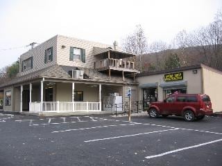
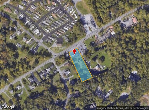
Property Record
2903 Pricetown Rd, Temple, PA 19560
NEARBY LISTINGS FOR SALE OR LEASE
Property Detail
2903 Pricetown Rd
Retailwithmorethanonenonretailuse
Berks
A
Pennsylvania
42011C0369G
1.19 AC
2025
Berks County
2025
Philadelphia
012901
Reading, PA
4,924 SF
22-5318-02-89-6474
DEMOGRAPHICS near 2903 Pricetown Rd
1 Mile
3 Mile
5 Mile
2024 Total Population
2,131
39,172
154,573
2029 Population
2,138
39,353
155,264
Pop Growth 2024-2029
+ 0.33%
+ 0.46%
+ 0.45%
Average Age
42
38
38
2024 Total Households
819
13,796
55,954
HH Growth 2024-2029
+ 0.49%
+ 0.49%
+ 0.47%
Median Household Inc
$72,296
$64,141
$53,282
Avg Household Size
2.50
2.70
2.60
2024 Avg HH Vehicles
2.00
2.00
2.00
Median Home Value
$202,715
$151,853
$155,599
Median Year Built
1979
1954
1953
Nearby Places
Map Layers
Map Styles
 Street
 Aerial
- Restaurants
- Banks
- Shops
- Fitness
- Groceries
PUBLIC TRANSPORTATION
AIRPORT
Lehigh Valley International
DRIVE
WALK
Distance
Lehigh Valley International
56 min
35.8 mi
Freight Ports
Port of Wilmington, RI
DRIVE
WALK
Distance
Port of Wilmington, RI
94 min
63.5 mi
SALE & LEASE HISTORY
LISTING DATE
SALE/LEASE

Sep 24, 2016
For Sale
Sep 24, 2016
For Sale
Nearby Properties
Address
Land Use
TOTAL SIZE
Lot Size
Zoning
Address
Land Use
TOTAL SIZE
Lot Size
Zoning
386,194 SF
29.21 AC
Address
Land Use
TOTAL SIZE
Lot Size
Zoning
203,665 SF
17.94 AC
Address
Land Use
TOTAL SIZE
Lot Size
Zoning
241,410 SF
44.78 AC
Address
Land Use
TOTAL SIZE
Lot Size
Zoning
80,864 SF
10.38 AC
Address
Land Use
TOTAL SIZE
Lot Size
Zoning
178,280 SF
19.15 AC
Address
Land Use
TOTAL SIZE
Lot Size
Zoning
347,124 SF
19.93 AC
Address
Land Use
TOTAL SIZE
Lot Size
Zoning
167,440 SF
13.03 AC
Address
Land Use
TOTAL SIZE
Lot Size
Zoning
105,272 SF
2.19 AC
Address
Land Use
TOTAL SIZE
Lot Size
Zoning
129,050 SF
Address
Land Use
TOTAL SIZE
Lot Size
Zoning
116,236 SF
9.39 AC
Address
Land Use
TOTAL SIZE
Lot Size
Zoning
164,648 SF
14.13 AC
Address
Land Use
TOTAL SIZE
Lot Size
Zoning
247,500 SF
16.49 AC
Address
Land Use
TOTAL SIZE
Lot Size
Zoning
209,490 SF
10.95 AC
Address
Land Use
TOTAL SIZE
Lot Size
Zoning
160,160 SF
7.32 AC
Address
Land Use
TOTAL SIZE
Lot Size
Zoning
270,000 SF
18.44 AC
Address
Land Use
TOTAL SIZE
Lot Size
Zoning
141,325 SF
16.09 AC
Address
Land Use
TOTAL SIZE
Lot Size
Zoning
21,440 SF
7.99 AC
Address
Land Use
TOTAL SIZE
Lot Size
Zoning
139,843 SF
12.90 AC
Address
Land Use
TOTAL SIZE
Lot Size
Zoning
127,216 SF
8.87 AC
Address
Land Use
TOTAL SIZE
Lot Size
Zoning
25,644 SF
9.29 AC
Address
Land Use
TOTAL SIZE
Lot Size
Zoning
156,495 SF
9.45 AC
Address
Land Use
TOTAL SIZE
Lot Size
Zoning
130,888 SF
11.43 AC
Address
Land Use
TOTAL SIZE
Lot Size
Zoning
233,687 SF
15.80 AC
Address
Land Use
TOTAL SIZE
Lot Size
Zoning
50,142 SF
10.29 AC
Address
Land Use
TOTAL SIZE
Lot Size
Zoning
79,867 SF
8.59 AC
Address
Land Use
TOTAL SIZE
Lot Size
Zoning
44,751 SF
4.31 AC
Address
Land Use
TOTAL SIZE
Lot Size
Zoning
294,803 SF
64.13 AC
Address
Land Use
TOTAL SIZE
Lot Size
Zoning
26,884 SF
4.12 AC
Address
Land Use
TOTAL SIZE
Lot Size
Zoning
144,000 SF
7.28 AC
Address
Land Use
TOTAL SIZE
Lot Size
Zoning
175,056 SF
14.87 AC
The World's #1 Commercial Real Estate Marketplace
Connect with us
© 2025 CoStar Group
The information above has been obtained from sources believed reliable. While we do not doubt its accuracy we have not verified it and make no guarantee, warranty or representation about it. It is your responsibility to independently confirm its accuracy and completeness. Any projections, opinions, assumptions, or estimates used are for example only and do not represent the current or future performance of the property. The value of this transaction to you depends on tax and other factors which should be evaluated by your tax, financial, and legal advisors. You and your advisors should conduct a careful, independent investigation of the property to determine to your satisfaction the suitability of the property for your needs.