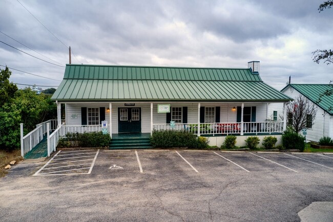
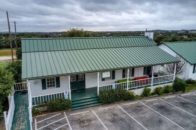
Property Record
2903 Ranch Road 620 N, Austin, TX 78734

Property Detail
2903 Ranch Road 620 N
Austin-Round Rock-San Marcos, TX
LOT 37 CARDINAL HILLS ESTATES UNIT 14
457641
Travis
Officebuilding
Texas
B and X Area of moderate flood hazard, usually the area between the limits of the 100-year and 500-year floods.
37
2025
0.80 AC
2025
Southwest
031500
Austin
3,494 SF
NEARBY LISTINGS FOR SALE OR LEASE
DEMOGRAPHICS near 2903 Ranch Road 620 N
1 mile
3 mile
5 mile
2025 Total Population
3,196
25,850
62,972
2030 Population
3,390
27,098
66,301
Pop Growth 2025-2030
+ 6.07%
+ 4.83%
+ 5.29%
Average Age
42
43
44
2025 Total Households
1,326
10,007
24,597
HH Growth 2025-2030
+ 6.71%
+ 5.66%
+ 6.07%
Median Household Inc
$111,736
$146,772
$148,918
Avg Household Size
2.40
2.60
2.50
2025 Avg HH Vehicles
2.00
2.00
2.00
Median Home Value
$774,816
$785,007
$801,379
Median Year Built
2002
2002
2004
Nearby Places
Map Layers
Map Styles
 Street
 Aerial
Layers
 Traffic
 Biking
Places
Listings with unknown addresses are not visible on the map
- Restaurants
- Banks
- Shops
- Fitness
- Groceries
PUBLIC TRANSPORTATION
AIRPORT
Austin-Bergstrom International
Drive
Walk
Distance
Austin-Bergstrom International
48 min
29.6 mi
Freight Ports
Calhoun Port
Drive
Walk
Distance
Calhoun Port
214 min
173.1 mi
SALE & LEASE HISTORY
LISTING DATE
SALE/LEASE

Apr 22, 2023
For Lease
Apr 02, 2021
For Lease
Nearby Properties
Address
Land Use
TOTAL SIZE
Lot Size
Zoning
Address
Land Use
TOTAL SIZE
Lot Size
Zoning
296,448 SF
37.39 AC
Address
Land Use
TOTAL SIZE
Lot Size
Zoning
235,808 SF
59.36 AC
Address
Land Use
TOTAL SIZE
Lot Size
Zoning
182,225 SF
30.33 AC
Address
Land Use
TOTAL SIZE
Lot Size
Zoning
136,518 SF
27.59 AC
Address
Land Use
TOTAL SIZE
Lot Size
Zoning
129,999 SF
9.88 AC
Address
Land Use
TOTAL SIZE
Lot Size
Zoning
34,756 SF
39.03 AC
Address
Land Use
TOTAL SIZE
Lot Size
Zoning
74.46 AC
Address
Land Use
TOTAL SIZE
Lot Size
Zoning
460.44 AC
Address
Land Use
TOTAL SIZE
Lot Size
Zoning
433.77 AC
Address
Land Use
TOTAL SIZE
Lot Size
Zoning
60,907 SF
8.50 AC
Address
Land Use
TOTAL SIZE
Lot Size
Zoning
123,300 SF
7.95 AC
Address
Land Use
TOTAL SIZE
Lot Size
Zoning
12,859 SF
36.56 AC
Address
Land Use
TOTAL SIZE
Lot Size
Zoning
100,000 SF
4.62 AC
Address
Land Use
TOTAL SIZE
Lot Size
Zoning
31.43 AC
Address
Land Use
TOTAL SIZE
Lot Size
Zoning
56,010 SF
4.61 AC
Address
Land Use
TOTAL SIZE
Lot Size
Zoning
1,440 SF
301.45 AC
Address
Land Use
TOTAL SIZE
Lot Size
Zoning
32,385 SF
3.97 AC
Address
Land Use
TOTAL SIZE
Lot Size
Zoning
Address
Land Use
TOTAL SIZE
Lot Size
Zoning
14.79 AC
Address
Land Use
TOTAL SIZE
Lot Size
Zoning
46.83 AC
Address
Land Use
TOTAL SIZE
Lot Size
Zoning
158.53 AC
Address
Land Use
TOTAL SIZE
Lot Size
Zoning
15,000 SF
12.51 AC
Address
Land Use
TOTAL SIZE
Lot Size
Zoning
148,500 SF
5.88 AC
Address
Land Use
TOTAL SIZE
Lot Size
Zoning
34,704 SF
2.24 AC
Address
Land Use
TOTAL SIZE
Lot Size
Zoning
68,651 SF
5.78 AC
Address
Land Use
TOTAL SIZE
Lot Size
Zoning
90,760 SF
7.98 AC
Address
Land Use
TOTAL SIZE
Lot Size
Zoning
21,288 SF
2.45 AC
Address
Land Use
TOTAL SIZE
Lot Size
Zoning
49,079 SF
4.47 AC
Address
Land Use
TOTAL SIZE
Lot Size
Zoning
42.96 AC
Address
Land Use
TOTAL SIZE
Lot Size
Zoning
45,381 SF
2.78 AC
The World's #1 Commercial Real Estate Marketplace
Connect with us
© 2026 CoStar Group
The information above has been obtained from sources believed reliable. While we do not doubt its accuracy we have not verified it and make no guarantee, warranty or representation about it. It is your responsibility to independently confirm its accuracy and completeness. Any projections, opinions, assumptions, or estimates used are for example only and do not represent the current or future performance of the property. The value of this transaction to you depends on tax and other factors which should be evaluated by your tax, financial, and legal advisors. You and your advisors should conduct a careful, independent investigation of the property to determine to your satisfaction the suitability of the property for your needs.