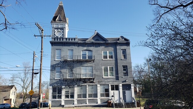
Property Record
2904 Alms Pl, Cincinnati, OH 45206
NEARBY LISTINGS FOR SALE OR LEASE
Property Detail
2904 Alms Pl
Cincinnati, OH-KY-IN
Lane Seminary Sub
066-0002-0260
CHAPEL & ALMS PL 50.88 X 95 PT LOT 78 LANE SEMINARY SUB
Commercialnec
Hamilton
X
Ohio
39061C0238E
78
2024
0.10 AC
2024
Walnut Hills
003700
Cincinnati/Dayton
10,710 SF
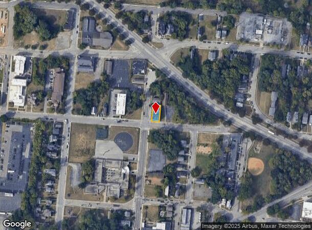
DEMOGRAPHICS near 2904 Alms Pl
1 Mile
3 Mile
5 Mile
2024 Total Population
18,179
164,474
320,714
2029 Population
18,522
166,157
323,396
Pop Growth 2024-2029
+ 1.89%
+ 1.02%
+ 0.84%
Average Age
39
36
37
2024 Total Households
9,296
74,752
145,182
HH Growth 2024-2029
+ 1.47%
+ 1.07%
+ 0.84%
Median Household Inc
$43,425
$55,695
$52,271
Avg Household Size
1.80
2.00
2.00
2024 Avg HH Vehicles
1.00
1.00
1.00
Median Home Value
$248,221
$276,168
$229,881
Median Year Built
1948
1948
1949
Nearby Places
Map Layers
Map Styles
 Street
 Aerial
- Restaurants
- Banks
- Shops
- Fitness
- Groceries
PUBLIC TRANSPORTATION
COMMUTER RAIL
Cincinnati Union Terminal (Cardinal - Amtrak)
DRIVE
WALK
Distance
Cincinnati Union Terminal (Cardinal - Amtrak)
11 min
4.9 mi
AIRPORT
Cincinnati/Northern Kentucky International
DRIVE
WALK
Distance
Cincinnati/Northern Kentucky International
32 min
17.0 mi
Freight Ports
Port of Toledo
DRIVE
WALK
Distance
Port of Toledo
241 min
203.0 mi
SALE & LEASE HISTORY
LISTING DATE
SALE/LEASE

Apr 18, 2025
For Sale
Nearby Properties
Address
Land Use
TOTAL SIZE
Lot Size
Zoning
Address
Land Use
TOTAL SIZE
Lot Size
Zoning
77.73 AC
IR
Address
Land Use
TOTAL SIZE
Lot Size
Zoning
6.35 AC
IR
Address
Land Use
TOTAL SIZE
Lot Size
Zoning
11.82 AC
Address
Land Use
TOTAL SIZE
Lot Size
Zoning
19.36 AC
Address
Land Use
TOTAL SIZE
Lot Size
Zoning
17.10 AC
DD
Address
Land Use
TOTAL SIZE
Lot Size
Zoning
1.97 AC
DD
Address
Land Use
TOTAL SIZE
Lot Size
Zoning
62.10 AC
Address
Land Use
TOTAL SIZE
Lot Size
Zoning
11.41 AC
IR
Address
Land Use
TOTAL SIZE
Lot Size
Zoning
22.45 AC
Address
Land Use
TOTAL SIZE
Lot Size
Zoning
13.80 AC
Address
Land Use
TOTAL SIZE
Lot Size
Zoning
9.55 AC
Address
Land Use
TOTAL SIZE
Lot Size
Zoning
3.09 AC
Address
Land Use
TOTAL SIZE
Lot Size
Zoning
2.80 AC
IR
Address
Land Use
TOTAL SIZE
Lot Size
Zoning
3.40 AC
IR
Address
Land Use
TOTAL SIZE
Lot Size
Zoning
Address
Land Use
TOTAL SIZE
Lot Size
Zoning
3.51 AC
DD
Address
Land Use
TOTAL SIZE
Lot Size
Zoning
21.34 AC
Address
Land Use
TOTAL SIZE
Lot Size
Zoning
27.30 AC
M2
Address
Land Use
TOTAL SIZE
Lot Size
Zoning
Address
Land Use
TOTAL SIZE
Lot Size
Zoning
153,312 SF
4 AC
Address
Land Use
TOTAL SIZE
Lot Size
Zoning
9.14 AC
Address
Land Use
TOTAL SIZE
Lot Size
Zoning
11.68 AC
Address
Land Use
TOTAL SIZE
Lot Size
Zoning
7.14 AC
Address
Land Use
TOTAL SIZE
Lot Size
Zoning
1.95 AC
Address
Land Use
TOTAL SIZE
Lot Size
Zoning
26,453 SF
19.91 AC
M2
Address
Land Use
TOTAL SIZE
Lot Size
Zoning
Address
Land Use
TOTAL SIZE
Lot Size
Zoning
2.46 AC
Address
Land Use
TOTAL SIZE
Lot Size
Zoning
844,128 SF
1.22 AC
DD
Address
Land Use
TOTAL SIZE
Lot Size
Zoning
0.43 AC
DD
Address
Land Use
TOTAL SIZE
Lot Size
Zoning
4.46 AC
DD
The World's #1 Commercial Real Estate Marketplace
Connect with us
© 2025 CoStar Group
The information above has been obtained from sources believed reliable. While we do not doubt its accuracy we have not verified it and make no guarantee, warranty or representation about it. It is your responsibility to independently confirm its accuracy and completeness. Any projections, opinions, assumptions, or estimates used are for example only and do not represent the current or future performance of the property. The value of this transaction to you depends on tax and other factors which should be evaluated by your tax, financial, and legal advisors. You and your advisors should conduct a careful, independent investigation of the property to determine to your satisfaction the suitability of the property for your needs.