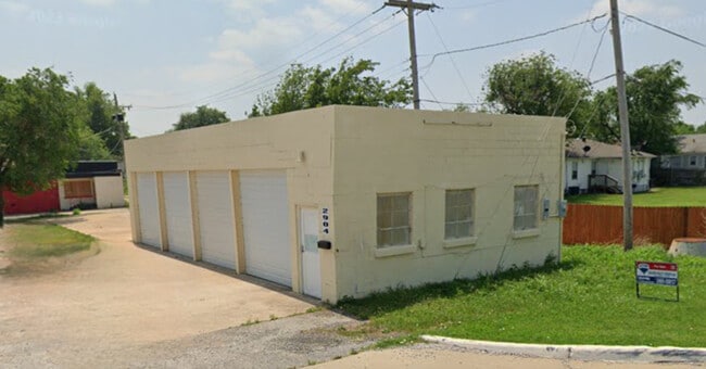
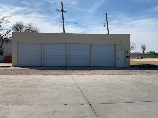
Property Record
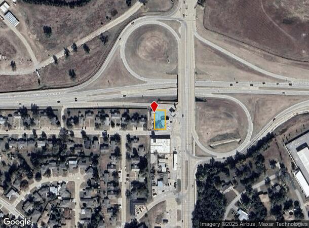
2904 Nw Fort Sill Blvd, Lawton, OK 73507
NEARBY LISTINGS FOR SALE OR LEASE
Property Detail
2904 Nw Fort Sill Blvd
Lawton, OK
Selected Investment
0027126
SELECTED INVESTMENT BLK 6 LOTS 1-4 (EXCEPT E 100' THEREOF SEE COVENANT)
Warehouse
Comanche
X
Oklahoma
40031C0269E
1-4
2024
0.19 AC
2025
Oklahoma West Area
000100
Other Market Areas
1,120 SF
DEMOGRAPHICS near 2904 Nw Fort Sill Blvd
1 Mile
3 Mile
5 Mile
2024 Total Population
8,659
47,454
89,782
2029 Population
9,024
49,279
92,893
Pop Growth 2024-2029
+ 4.22%
+ 3.85%
+ 3.47%
Average Age
32
34
36
2024 Total Households
2,765
17,033
33,482
HH Growth 2024-2029
+ 4.63%
+ 4.29%
+ 3.73%
Median Household Inc
$34,654
$39,330
$44,676
Avg Household Size
2.50
2.40
2.40
2024 Avg HH Vehicles
1.00
1.00
2.00
Median Home Value
$70,975
$92,833
$131,040
Median Year Built
1962
1964
1973
Nearby Places
Map Layers
Map Styles
 Street
 Aerial
- Restaurants
- Banks
- Shops
- Fitness
- Groceries
PUBLIC TRANSPORTATION
AIRPORT
Lawton-Fort Sill Regional
DRIVE
WALK
Distance
Lawton-Fort Sill Regional
13 min
6.3 mi
Freight Ports
Tulsa Port Of Catoosa
DRIVE
WALK
Distance
Tulsa Port Of Catoosa
222 min
208.2 mi
SALE & LEASE HISTORY
LISTING DATE
SALE/LEASE

Sep 20, 2017
For Sale
Mar 03, 2022
For Sale
Jan 20, 2025
For Sale
Apr 14, 2023
For Lease
Nearby Properties
Address
Land Use
TOTAL SIZE
Lot Size
Zoning
Address
Land Use
TOTAL SIZE
Lot Size
Zoning
2,288 SF
2.94 AC
Address
Land Use
TOTAL SIZE
Lot Size
Zoning
22,987 SF
3.40 AC
Address
Land Use
TOTAL SIZE
Lot Size
Zoning
14,000 SF
17.19 AC
Address
Land Use
TOTAL SIZE
Lot Size
Zoning
114,352 SF
14.84 AC
Address
Land Use
TOTAL SIZE
Lot Size
Zoning
800 SF
15.64 AC
Address
Land Use
TOTAL SIZE
Lot Size
Zoning
195,881 SF
15.39 AC
Address
Land Use
TOTAL SIZE
Lot Size
Zoning
12,068 SF
5.31 AC
Address
Land Use
TOTAL SIZE
Lot Size
Zoning
16,996 SF
12.16 AC
Address
Land Use
TOTAL SIZE
Lot Size
Zoning
123,414 SF
17.50 AC
Address
Land Use
TOTAL SIZE
Lot Size
Zoning
117,301 SF
13.83 AC
Address
Land Use
TOTAL SIZE
Lot Size
Zoning
63,224 SF
2.66 AC
Address
Land Use
TOTAL SIZE
Lot Size
Zoning
2,688 SF
4.50 AC
Address
Land Use
TOTAL SIZE
Lot Size
Zoning
57,096 SF
16.03 AC
Address
Land Use
TOTAL SIZE
Lot Size
Zoning
6,251 SF
3.70 AC
Address
Land Use
TOTAL SIZE
Lot Size
Zoning
7,960 SF
0.58 AC
Address
Land Use
TOTAL SIZE
Lot Size
Zoning
3,292 SF
1.13 AC
Address
Land Use
TOTAL SIZE
Lot Size
Zoning
52,568 SF
1.50 AC
Address
Land Use
TOTAL SIZE
Lot Size
Zoning
18,312 SF
3.08 AC
Address
Land Use
TOTAL SIZE
Lot Size
Zoning
61,984 SF
1.58 AC
Address
Land Use
TOTAL SIZE
Lot Size
Zoning
53,432 SF
1.88 AC
Address
Land Use
TOTAL SIZE
Lot Size
Zoning
95,268 SF
6.20 AC
Address
Land Use
TOTAL SIZE
Lot Size
Zoning
11,368 SF
7.42 AC
Address
Land Use
TOTAL SIZE
Lot Size
Zoning
5,022 SF
0.67 AC
Address
Land Use
TOTAL SIZE
Lot Size
Zoning
30,028 SF
1.47 AC
Address
Land Use
TOTAL SIZE
Lot Size
Zoning
75,382 SF
7.54 AC
Address
Land Use
TOTAL SIZE
Lot Size
Zoning
4,384 SF
1.29 AC
Address
Land Use
TOTAL SIZE
Lot Size
Zoning
51,852 SF
2.17 AC
Address
Land Use
TOTAL SIZE
Lot Size
Zoning
3,300 SF
4.14 AC
Address
Land Use
TOTAL SIZE
Lot Size
Zoning
88,460 SF
5.55 AC
Address
Land Use
TOTAL SIZE
Lot Size
Zoning
4,950 SF
0.52 AC
The World's #1 Commercial Real Estate Marketplace
Connect with us
© 2025 CoStar Group
The information above has been obtained from sources believed reliable. While we do not doubt its accuracy we have not verified it and make no guarantee, warranty or representation about it. It is your responsibility to independently confirm its accuracy and completeness. Any projections, opinions, assumptions, or estimates used are for example only and do not represent the current or future performance of the property. The value of this transaction to you depends on tax and other factors which should be evaluated by your tax, financial, and legal advisors. You and your advisors should conduct a careful, independent investigation of the property to determine to your satisfaction the suitability of the property for your needs.