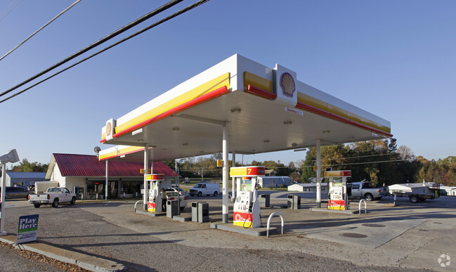
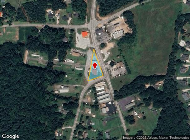
Property Record
2904 Pelzer Hwy, Easley, SC 29642
NEARBY LISTINGS FOR SALE OR LEASE
-
-
View all Easley listings for sale on LoopNet.com
Property Detail
2904 Pelzer Hwy
162-02-01-015
Sequoia Hills
Commercialnec
CP 102/883 F396 D220 PP 093/690 HWY 8
X
Anderson
45007C0040E
South Carolina
2023
2 AC
2024
Anderson Cy N of I-85
010108
Greenville/Spartanburg
2,415 SF
Greenville-Anderson-Greer, SC
DEMOGRAPHICS near 2904 Pelzer Hwy
1 mile
3 mile
5 mile
2024 Total Population
2,265
18,277
53,098
2029 Population
2,406
19,287
55,870
Pop Growth 2024-2029
+ 6.23%
+ 5.53%
+ 5.22%
Average Age
40
41
41
2024 Total Households
802
6,782
20,710
HH Growth 2024-2029
+ 6.36%
+ 5.54%
+ 5.26%
Median Household Inc
$81,000
$73,637
$64,699
Avg Household Size
2.80
2.60
2.50
2024 Avg HH Vehicles
2.00
2.00
2.00
Median Home Value
$226,804
$239,445
$219,392
Median Year Built
1997
1993
1991
Nearby Places
Map Layers
Map Styles
 Street
 Aerial
Transit
 Traffic
 Biking
Places
Listings with unknown addresses are not visible on the map
- Restaurants
- Banks
- Shops
- Fitness
- Groceries
PUBLIC TRANSPORTATION
AIRPORT
Greenville Spartanburg International
Drive
Walk
Distance
Greenville Spartanburg International
42 min
27.0 mi
Nearby Properties
Address
Land Use
TOTAL SIZE
Lot Size
Zoning
Address
Land Use
TOTAL SIZE
Lot Size
Zoning
162.06 AC
R10
Address
Land Use
TOTAL SIZE
Lot Size
Zoning
177,695 SF
20.43 AC
Address
Land Use
TOTAL SIZE
Lot Size
Zoning
9,800 SF
5.94 AC
R10
Address
Land Use
TOTAL SIZE
Lot Size
Zoning
2,644 SF
0.54 AC
R 10 ONE F
Address
Land Use
TOTAL SIZE
Lot Size
Zoning
27.43 AC
R 10 ONE F
Address
Land Use
TOTAL SIZE
Lot Size
Zoning
42.26 AC
OFFICE INS
Address
Land Use
TOTAL SIZE
Lot Size
Zoning
2,571 SF
0.63 AC
R 10 ONE F
Address
Land Use
TOTAL SIZE
Lot Size
Zoning
2,098 SF
0.23 AC
R10
Address
Land Use
TOTAL SIZE
Lot Size
Zoning
3.98 AC
NEIGHBORHO
Address
Land Use
TOTAL SIZE
Lot Size
Zoning
2,208 SF
1.32 AC
R 10 ONE F
Address
Land Use
TOTAL SIZE
Lot Size
Zoning
3,034 SF
0.47 AC
R 10 ONE F
Address
Land Use
TOTAL SIZE
Lot Size
Zoning
4,084 SF
0.46 AC
R 10 ONE F
Address
Land Use
TOTAL SIZE
Lot Size
Zoning
55 AC
R 10 ONE F
Address
Land Use
TOTAL SIZE
Lot Size
Zoning
16,290 SF
4.68 AC
Address
Land Use
TOTAL SIZE
Lot Size
Zoning
2,350 SF
1.30 AC
R 10 ONE F
Address
Land Use
TOTAL SIZE
Lot Size
Zoning
1,882 SF
0.16 AC
R 6 ONE FA
Address
Land Use
TOTAL SIZE
Lot Size
Zoning
2,756 SF
2.78 AC
R 10 ONE F
Address
Land Use
TOTAL SIZE
Lot Size
Zoning
4,460 SF
0.45 AC
R 10 ONE F
Address
Land Use
TOTAL SIZE
Lot Size
Zoning
1,683 SF
0.79 AC
R 10 ONE F
Address
Land Use
TOTAL SIZE
Lot Size
Zoning
4,655 SF
0.32 AC
R
Address
Land Use
TOTAL SIZE
Lot Size
Zoning
1,904 SF
17.74 AC
R10
Address
Land Use
TOTAL SIZE
Lot Size
Zoning
4,605 SF
0.32 AC
R10
Address
Land Use
TOTAL SIZE
Lot Size
Zoning
2,263 SF
0.58 AC
Address
Land Use
TOTAL SIZE
Lot Size
Zoning
2,771 SF
0.67 AC
Address
Land Use
TOTAL SIZE
Lot Size
Zoning
2,380 SF
0.40 AC
R 10 ONE F
Address
Land Use
TOTAL SIZE
Lot Size
Zoning
8.03 AC
IND
Address
Land Use
TOTAL SIZE
Lot Size
Zoning
2,219 SF
0.48 AC
R 10 ONE F
Address
Land Use
TOTAL SIZE
Lot Size
Zoning
2,686 SF
0.23 AC
GR2
Address
Land Use
TOTAL SIZE
Lot Size
Zoning
4,509 SF
0.97 AC
Address
Land Use
TOTAL SIZE
Lot Size
Zoning
2,682 SF
0.57 AC
The World's #1 Commercial Real Estate Marketplace
Connect with us
© 2026 CoStar Group
The information above has been obtained from sources believed reliable. While we do not doubt its accuracy we have not verified it and make no guarantee, warranty or representation about it. It is your responsibility to independently confirm its accuracy and completeness. Any projections, opinions, assumptions, or estimates used are for example only and do not represent the current or future performance of the property. The value of this transaction to you depends on tax and other factors which should be evaluated by your tax, financial, and legal advisors. You and your advisors should conduct a careful, independent investigation of the property to determine to your satisfaction the suitability of the property for your needs.