No Photo
Property Record
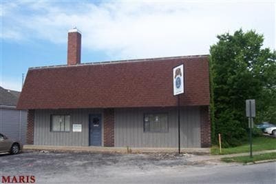
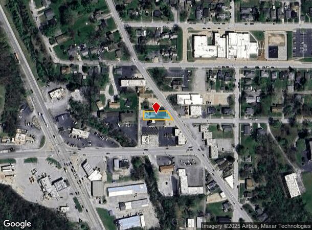
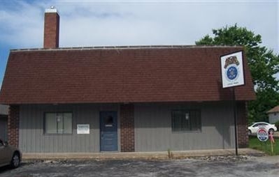
2905 Saint Marys Ave, Hannibal, MO 63401
NEARBY LISTINGS FOR SALE OR LEASE
-
-
View all Hannibal listings for sale on LoopNet.com
Property Detail
2905 Saint Marys Ave
Hannibal, MO
Garth
010.09.30.4.06.002.000
SUBD GARTH, BLK 6, ALL LOT 13 DIM MAP-60 X 185 IRR
Commercialnec
Marion
AE
Missouri
29127C0310D
13
2024
0.20 AC
2024
Missouri North Area
960600
Other Market Areas
DEMOGRAPHICS near 2905 Saint Marys Ave
1 Mile
3 Mile
5 Mile
2024 Total Population
7,614
19,528
21,443
2029 Population
7,615
19,516
21,415
Pop Growth 2024-2029
+ 0.01%
(0.06%)
(0.13%)
Average Age
40
40
40
2024 Total Households
3,058
7,902
8,642
HH Growth 2024-2029
0.00%
(0.09%)
(0.16%)
Median Household Inc
$47,580
$51,804
$54,492
Avg Household Size
2.30
2.30
2.30
2024 Avg HH Vehicles
2.00
2.00
2.00
Median Home Value
$124,890
$138,785
$143,047
Median Year Built
1957
1969
1971
Nearby Places
Map Layers
Map Styles
 Street
 Aerial
- Restaurants
- Banks
- Shops
- Fitness
- Groceries
Nearby Properties
Address
Land Use
TOTAL SIZE
Lot Size
Zoning
Address
Land Use
TOTAL SIZE
Lot Size
Zoning
Address
Land Use
TOTAL SIZE
Lot Size
Zoning
600 SF
50.04 AC
Address
Land Use
TOTAL SIZE
Lot Size
Zoning
186,518 SF
20.60 AC
Address
Land Use
TOTAL SIZE
Lot Size
Zoning
81,217 SF
7.40 AC
Address
Land Use
TOTAL SIZE
Lot Size
Zoning
103,290 SF
19.80 AC
Address
Land Use
TOTAL SIZE
Lot Size
Zoning
2,430 SF
15 AC
Address
Land Use
TOTAL SIZE
Lot Size
Zoning
1.60 AC
Address
Land Use
TOTAL SIZE
Lot Size
Zoning
1.13 AC
SR
Address
Land Use
TOTAL SIZE
Lot Size
Zoning
155,960 SF
16.40 AC
Address
Land Use
TOTAL SIZE
Lot Size
Zoning
3.30 AC
Address
Land Use
TOTAL SIZE
Lot Size
Zoning
75,953 SF
3.80 AC
Address
Land Use
TOTAL SIZE
Lot Size
Zoning
40,894 SF
11.50 AC
Address
Land Use
TOTAL SIZE
Lot Size
Zoning
106,380 SF
6.40 AC
Address
Land Use
TOTAL SIZE
Lot Size
Zoning
1.80 AC
Address
Land Use
TOTAL SIZE
Lot Size
Zoning
1,999 SF
9.90 AC
Address
Land Use
TOTAL SIZE
Lot Size
Zoning
Address
Land Use
TOTAL SIZE
Lot Size
Zoning
Address
Land Use
TOTAL SIZE
Lot Size
Zoning
4.80 AC
Address
Land Use
TOTAL SIZE
Lot Size
Zoning
7.80 AC
Address
Land Use
TOTAL SIZE
Lot Size
Zoning
9.71 AC
Address
Land Use
TOTAL SIZE
Lot Size
Zoning
47,700 SF
0.90 AC
Address
Land Use
TOTAL SIZE
Lot Size
Zoning
13,751 SF
1.60 AC
Address
Land Use
TOTAL SIZE
Lot Size
Zoning
Address
Land Use
TOTAL SIZE
Lot Size
Zoning
7.07 AC
Address
Land Use
TOTAL SIZE
Lot Size
Zoning
5.20 AC
Address
Land Use
TOTAL SIZE
Lot Size
Zoning
20,260 SF
9.10 AC
Address
Land Use
TOTAL SIZE
Lot Size
Zoning
2,183 SF
2.90 AC
Address
Land Use
TOTAL SIZE
Lot Size
Zoning
1.34 AC
Address
Land Use
TOTAL SIZE
Lot Size
Zoning
Address
Land Use
TOTAL SIZE
Lot Size
Zoning
1,092 SF
14.50 AC
The World's #1 Commercial Real Estate Marketplace
Connect with us
© 2025 CoStar Group
The information above has been obtained from sources believed reliable. While we do not doubt its accuracy we have not verified it and make no guarantee, warranty or representation about it. It is your responsibility to independently confirm its accuracy and completeness. Any projections, opinions, assumptions, or estimates used are for example only and do not represent the current or future performance of the property. The value of this transaction to you depends on tax and other factors which should be evaluated by your tax, financial, and legal advisors. You and your advisors should conduct a careful, independent investigation of the property to determine to your satisfaction the suitability of the property for your needs.