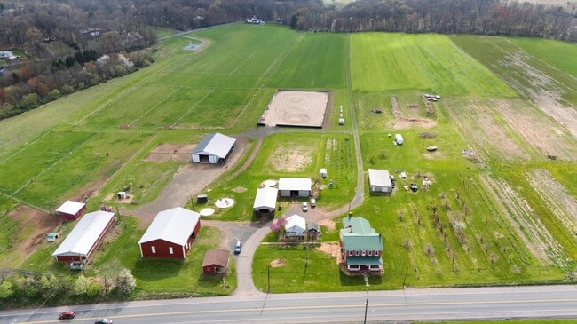
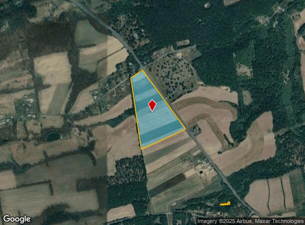
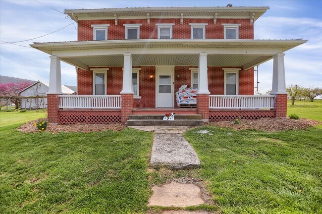
Property Record
2905 State Route 54, Elysburg, PA 17824
NEARBY LISTINGS FOR SALE OR LEASE
Property Detail
2905 State Route 54
Sunbury, PA
Subdivision Plans Of Hoagland Sub
040-00-051-110
30.34 AC
Vacantlandnec
Northumberland
X
Pennsylvania
42037C0410F
30.34 AC
2025
Pennsylvania Central Area
2025
Other Market Areas
080800
DEMOGRAPHICS near 2905 State Route 54
1 Mile
3 Mile
5 Mile
2024 Total Population
191
2,959
27,591
2029 Population
185
2,893
27,731
Pop Growth 2024-2029
(3.14%)
(2.23%)
+ 0.51%
Average Age
47
46
44
2024 Total Households
78
1,169
11,420
HH Growth 2024-2029
(2.56%)
(2.22%)
+ 0.60%
Median Household Inc
$81,250
$102,042
$48,804
Avg Household Size
2.40
2.30
2.20
2024 Avg HH Vehicles
2.00
2.00
2.00
Median Home Value
$243,333
$236,546
$98,948
Median Year Built
1975
1976
1948
Nearby Places
Map Layers
Map Styles
 Street
 Aerial
- Restaurants
- Banks
- Shops
- Fitness
- Groceries
SALE & LEASE HISTORY
LISTING DATE
SALE/LEASE

Apr 22, 2024
For Sale
Nearby Properties
Address
Land Use
TOTAL SIZE
Lot Size
Zoning
Address
Land Use
TOTAL SIZE
Lot Size
Zoning
226.30 AC
Address
Land Use
TOTAL SIZE
Lot Size
Zoning
53.24 AC
Address
Land Use
TOTAL SIZE
Lot Size
Zoning
111.70 AC
Address
Land Use
TOTAL SIZE
Lot Size
Zoning
92.16 AC
Address
Land Use
TOTAL SIZE
Lot Size
Zoning
92.64 AC
Address
Land Use
TOTAL SIZE
Lot Size
Zoning
117.16 AC
Address
Land Use
TOTAL SIZE
Lot Size
Zoning
1,888 SF
23.08 AC
Address
Land Use
TOTAL SIZE
Lot Size
Zoning
1,248 SF
7.50 AC
Address
Land Use
TOTAL SIZE
Lot Size
Zoning
2.32 AC
Address
Land Use
TOTAL SIZE
Lot Size
Zoning
12.35 AC
Address
Land Use
TOTAL SIZE
Lot Size
Zoning
1.80 AC
Address
Land Use
TOTAL SIZE
Lot Size
Zoning
3.28 AC
Address
Land Use
TOTAL SIZE
Lot Size
Zoning
3.42 AC
Address
Land Use
TOTAL SIZE
Lot Size
Zoning
3.04 AC
Address
Land Use
TOTAL SIZE
Lot Size
Zoning
7.53 AC
Address
Land Use
TOTAL SIZE
Lot Size
Zoning
86.68 AC
Address
Land Use
TOTAL SIZE
Lot Size
Zoning
0.42 AC
Address
Land Use
TOTAL SIZE
Lot Size
Zoning
Address
Land Use
TOTAL SIZE
Lot Size
Zoning
17.22 AC
Address
Land Use
TOTAL SIZE
Lot Size
Zoning
24.72 AC
Address
Land Use
TOTAL SIZE
Lot Size
Zoning
1.29 AC
Address
Land Use
TOTAL SIZE
Lot Size
Zoning
7.92 AC
Address
Land Use
TOTAL SIZE
Lot Size
Zoning
0.92 AC
Address
Land Use
TOTAL SIZE
Lot Size
Zoning
124.77 AC
Address
Land Use
TOTAL SIZE
Lot Size
Zoning
1.10 AC
Address
Land Use
TOTAL SIZE
Lot Size
Zoning
0.57 AC
Address
Land Use
TOTAL SIZE
Lot Size
Zoning
0.99 AC
Address
Land Use
TOTAL SIZE
Lot Size
Zoning
2,335 SF
68.82 AC
Address
Land Use
TOTAL SIZE
Lot Size
Zoning
4.13 AC
Address
Land Use
TOTAL SIZE
Lot Size
Zoning
0.61 AC
The World's #1 Commercial Real Estate Marketplace
Connect with us
© 2025 CoStar Group
The information above has been obtained from sources believed reliable. While we do not doubt its accuracy we have not verified it and make no guarantee, warranty or representation about it. It is your responsibility to independently confirm its accuracy and completeness. Any projections, opinions, assumptions, or estimates used are for example only and do not represent the current or future performance of the property. The value of this transaction to you depends on tax and other factors which should be evaluated by your tax, financial, and legal advisors. You and your advisors should conduct a careful, independent investigation of the property to determine to your satisfaction the suitability of the property for your needs.