Property Record
2907 Caddiefield Rd, Saint Louis, MO 63136
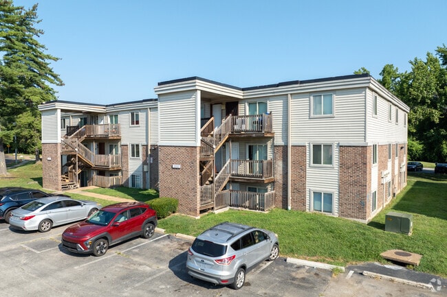
Property Detail
2907 Caddiefield Rd
12G-14-0788
KENSINGTON
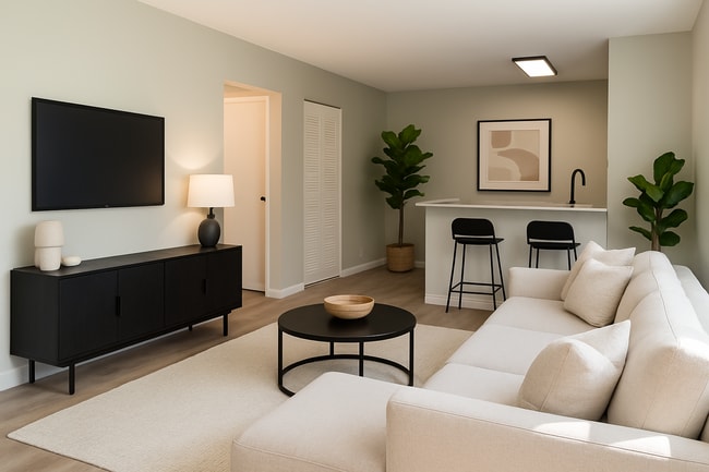
Apartment
Saint Louis
R5
Missouri
AE The base floodplain where base flood elevations are provided. AE Zones are now used on new format FIRMs instead of A1-A30 Zones.
28.28 AC
2024
Ferguson
2025
St. Louis
212002
St. Louis, MO-IL
169,128 SF
NEARBY LISTINGS FOR SALE OR LEASE
DEMOGRAPHICS near 2907 Caddiefield Rd
1 mile
3 mile
5 mile
2025 Total Population
14,213
106,023
245,621
2030 Population
14,638
107,303
248,235
Pop Growth 2025-2030
+ 2.99%
+ 1.21%
+ 1.06%
Average Age
36
40
40
2025 Total Households
5,893
43,656
99,779
HH Growth 2025-2030
+ 2.82%
+ 1.06%
+ 0.94%
Median Household Inc
$38,702
$44,800
$48,198
Avg Household Size
2.30
2.30
2.40
2025 Avg HH Vehicles
1.00
1.00
1.00
Median Home Value
$63,072
$82,768
$99,448
Median Year Built
1962
1956
1957
Nearby Places
Map Layers
Map Styles
 Street
 Aerial
Layers
 Traffic
 Biking
Places
Listings with unknown addresses are not visible on the map
- Restaurants
- Banks
- Shops
- Fitness
- Groceries
PUBLIC TRANSPORTATION
COMMUTER RAIL
North Hanley (Lambert Airport Shiloh-Scott - St. Louis MetroLink (MetroLink))
Drive
Walk
Distance
North Hanley (Lambert Airport Shiloh-Scott - St. Louis MetroLink (MetroLink))
8 min
4.6 mi
Um St. Louis North (Lambert Airport Shiloh-Scott - St. Louis MetroLink (MetroLink))
Drive
Walk
Distance
Um St. Louis North (Lambert Airport Shiloh-Scott - St. Louis MetroLink (MetroLink))
9 min
4.6 mi
AIRPORT
St Louis Lambert International
Drive
Walk
Distance
St Louis Lambert International
11 min
5.4 mi
Scott AFB/Midamerica St Louis
Drive
Walk
Distance
Scott AFB/Midamerica St Louis
53 min
35.3 mi
Freight Ports
Port Milwaukee
Drive
Walk
Distance
Port Milwaukee
424 min
372.9 mi
Nearby Properties
Address
Land Use
TOTAL SIZE
Lot Size
Zoning
Address
Land Use
TOTAL SIZE
Lot Size
Zoning
72,612 SF
118.34 AC
3INSTU
Address
Land Use
TOTAL SIZE
Lot Size
Zoning
25,545 SF
82.84 AC
R1B
Address
Land Use
TOTAL SIZE
Lot Size
Zoning
42.40 AC
M2
Address
Land Use
TOTAL SIZE
Lot Size
Zoning
231,336 SF
18.88 AC
7M-2
Address
Land Use
TOTAL SIZE
Lot Size
Zoning
151,640 SF
5.38 AC
D
Address
Land Use
TOTAL SIZE
Lot Size
Zoning
0.73 AC
B
Address
Land Use
TOTAL SIZE
Lot Size
Zoning
460,170 SF
152.70 AC
22M-1
Address
Land Use
TOTAL SIZE
Lot Size
Zoning
5,640 SF
10.42 AC
A
Address
Land Use
TOTAL SIZE
Lot Size
Zoning
303,535 SF
16.44 AC
B
Address
Land Use
TOTAL SIZE
Lot Size
Zoning
226,000 SF
34.48 AC
7M-2
Address
Land Use
TOTAL SIZE
Lot Size
Zoning
19.94 AC
39SFR
Address
Land Use
TOTAL SIZE
Lot Size
Zoning
675 SF
20.38 AC
R5
Address
Land Use
TOTAL SIZE
Lot Size
Zoning
58,818 SF
8.02 AC
22C-1
Address
Land Use
TOTAL SIZE
Lot Size
Zoning
83,705 SF
4.82 AC
7M-2
Address
Land Use
TOTAL SIZE
Lot Size
Zoning
6,366 SF
25.07 AC
22R-1C
Address
Land Use
TOTAL SIZE
Lot Size
Zoning
15.59 AC
R4
Address
Land Use
TOTAL SIZE
Lot Size
Zoning
448,714 SF
34.05 AC
22M-1
Address
Land Use
TOTAL SIZE
Lot Size
Zoning
148,974 SF
17.04 AC
C-8
Address
Land Use
TOTAL SIZE
Lot Size
Zoning
5.74 AC
C1
Address
Land Use
TOTAL SIZE
Lot Size
Zoning
108,753 SF
18.44 AC
31C-3
Address
Land Use
TOTAL SIZE
Lot Size
Zoning
218,234 SF
14.53 AC
7M-2
Address
Land Use
TOTAL SIZE
Lot Size
Zoning
14,150 SF
20 AC
39SFR
Address
Land Use
TOTAL SIZE
Lot Size
Zoning
12.98 AC
22R-1D
Address
Land Use
TOTAL SIZE
Lot Size
Zoning
4.07 AC
31R-1
Address
Land Use
TOTAL SIZE
Lot Size
Zoning
20.34 AC
NU
Address
Land Use
TOTAL SIZE
Lot Size
Zoning
1.80 AC
31R-1
Address
Land Use
TOTAL SIZE
Lot Size
Zoning
39,462 SF
8.64 AC
22C-2
Address
Land Use
TOTAL SIZE
Lot Size
Zoning
14,314 SF
11.53 AC
24R4
Address
Land Use
TOTAL SIZE
Lot Size
Zoning
10.69 AC
R3
Address
Land Use
TOTAL SIZE
Lot Size
Zoning
10,362 SF
19.03 AC
81R-2
The World's #1 Commercial Real Estate Marketplace
Connect with us
© 2026 CoStar Group
The information above has been obtained from sources believed reliable. While we do not doubt its accuracy we have not verified it and make no guarantee, warranty or representation about it. It is your responsibility to independently confirm its accuracy and completeness. Any projections, opinions, assumptions, or estimates used are for example only and do not represent the current or future performance of the property. The value of this transaction to you depends on tax and other factors which should be evaluated by your tax, financial, and legal advisors. You and your advisors should conduct a careful, independent investigation of the property to determine to your satisfaction the suitability of the property for your needs.