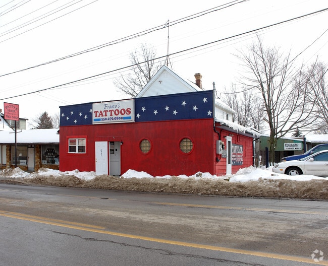
Property Record
2907 Mahoning Ave, Youngstown, OH 44509

NEARBY LISTINGS FOR SALE OR LEASE
Property Detail
2907 Mahoning Ave
Youngstown/Warren/Boardman
Mahoning
Youngstown-Warren-Boardman, OH-PA
LOT 20497 46 X 150 MAHONING
53-168-0-223.00-0
Mahoning
Commercialnec
Ohio
2024
20497
2024
0.16 AC
802800
Youngstown
5,716 SF
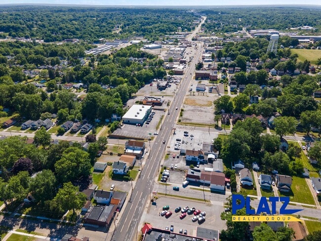
DEMOGRAPHICS near 2907 Mahoning Ave
1 Mile
3 Mile
5 Mile
2024 Total Population
8,186
54,572
132,351
2029 Population
8,058
53,856
130,834
Pop Growth 2024-2029
(1.56%)
(1.31%)
(1.15%)
Average Age
39
41
41
2024 Total Households
3,512
24,170
56,665
HH Growth 2024-2029
(1.71%)
(1.51%)
(1.28%)
Median Household Inc
$36,141
$37,138
$42,779
Avg Household Size
2.20
2.10
2.20
2024 Avg HH Vehicles
1.00
1.00
2.00
Median Home Value
$58,206
$80,808
$96,575
Median Year Built
1952
1957
1958
Nearby Places
Map Layers
Map Styles
 Street
 Aerial
- Restaurants
- Banks
- Shops
- Fitness
- Groceries
SALE & LEASE HISTORY
LISTING DATE
SALE/LEASE

Sep 22, 2017
For Sale
Jul 26, 2022
For Sale
Nearby Properties
Address
Land Use
TOTAL SIZE
Lot Size
Zoning
Address
Land Use
TOTAL SIZE
Lot Size
Zoning
981,460 SF
74.87 AC
Address
Land Use
TOTAL SIZE
Lot Size
Zoning
674,524 SF
7.89 AC
Address
Land Use
TOTAL SIZE
Lot Size
Zoning
119,241 SF
1.30 AC
Address
Land Use
TOTAL SIZE
Lot Size
Zoning
188,134 SF
12.60 AC
R1
Address
Land Use
TOTAL SIZE
Lot Size
Zoning
102,465 SF
1.44 AC
Address
Land Use
TOTAL SIZE
Lot Size
Zoning
165,980 SF
1.69 AC
Address
Land Use
TOTAL SIZE
Lot Size
Zoning
127,210 SF
12.43 AC
R1
Address
Land Use
TOTAL SIZE
Lot Size
Zoning
1.43 AC
Address
Land Use
TOTAL SIZE
Lot Size
Zoning
227,713 SF
15.07 AC
Address
Land Use
TOTAL SIZE
Lot Size
Zoning
122,806 SF
9.46 AC
R1
Address
Land Use
TOTAL SIZE
Lot Size
Zoning
131,643 SF
2.38 AC
Address
Land Use
TOTAL SIZE
Lot Size
Zoning
96,748 SF
29.17 AC
Address
Land Use
TOTAL SIZE
Lot Size
Zoning
186,576 SF
2.37 AC
Address
Land Use
TOTAL SIZE
Lot Size
Zoning
6,207 SF
0.88 AC
Address
Land Use
TOTAL SIZE
Lot Size
Zoning
1.89 AC
Address
Land Use
TOTAL SIZE
Lot Size
Zoning
93,891 SF
0.17 AC
Address
Land Use
TOTAL SIZE
Lot Size
Zoning
139,820 SF
7.10 AC
Address
Land Use
TOTAL SIZE
Lot Size
Zoning
446,250 SF
43.88 AC
Address
Land Use
TOTAL SIZE
Lot Size
Zoning
324,442 SF
54 AC
R1
Address
Land Use
TOTAL SIZE
Lot Size
Zoning
172,733 SF
2.75 AC
Address
Land Use
TOTAL SIZE
Lot Size
Zoning
72,725 SF
5.03 AC
Address
Land Use
TOTAL SIZE
Lot Size
Zoning
68,058 SF
3.54 AC
Address
Land Use
TOTAL SIZE
Lot Size
Zoning
161,758 SF
0.71 AC
Address
Land Use
TOTAL SIZE
Lot Size
Zoning
101,687 SF
9.93 AC
Address
Land Use
TOTAL SIZE
Lot Size
Zoning
96,194 SF
1.42 AC
Address
Land Use
TOTAL SIZE
Lot Size
Zoning
96,184 SF
0.82 AC
Address
Land Use
TOTAL SIZE
Lot Size
Zoning
108,743 SF
0.25 AC
Address
Land Use
TOTAL SIZE
Lot Size
Zoning
106,598 SF
0.17 AC
Address
Land Use
TOTAL SIZE
Lot Size
Zoning
37,644 SF
2.73 AC
Address
Land Use
TOTAL SIZE
Lot Size
Zoning
80,125 SF
0.66 AC
The World's #1 Commercial Real Estate Marketplace
Connect with us
© 2025 CoStar Group
The information above has been obtained from sources believed reliable. While we do not doubt its accuracy we have not verified it and make no guarantee, warranty or representation about it. It is your responsibility to independently confirm its accuracy and completeness. Any projections, opinions, assumptions, or estimates used are for example only and do not represent the current or future performance of the property. The value of this transaction to you depends on tax and other factors which should be evaluated by your tax, financial, and legal advisors. You and your advisors should conduct a careful, independent investigation of the property to determine to your satisfaction the suitability of the property for your needs.