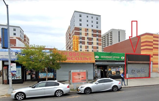
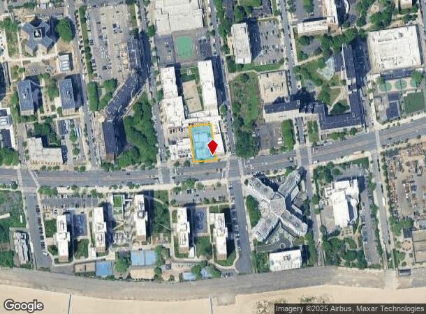
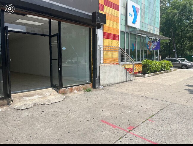
Property Record
2907 Surf Ave, Brooklyn, NY 11224

NEARBY LISTINGS FOR SALE OR LEASE
Property Detail
2907 Surf Ave
07051-0048
DOCID-2016042600580001
Storebuilding
Kings
AE
New York
3604970353F
48
2024
0.33 AC
2025
South Brooklyn
034200
Long Island (New York)
7,588 SF
New York-Jersey City-White Plains, NY-NJ
DEMOGRAPHICS near 2907 Surf Ave
1 Mile
3 Mile
5 Mile
2024 Total Population
37,107
343,891
968,360
2029 Population
35,687
319,688
901,520
Pop Growth 2024-2029
(3.83%)
(7.04%)
(6.90%)
Average Age
44
43
40
2024 Total Households
14,088
125,134
332,892
HH Growth 2024-2029
(4.39%)
(7.37%)
(7.16%)
Median Household Inc
$30,862
$55,910
$63,415
Avg Household Size
2.40
2.60
2.80
2024 Avg HH Vehicles
1.00
1.00
1.00
Median Home Value
$697,664
$785,829
$786,152
Median Year Built
1967
1949
1948
Nearby Places
Map Layers
Map Styles
 Street
 Aerial
- Restaurants
- Banks
- Shops
- Fitness
- Groceries
PUBLIC TRANSPORTATION
TRANSIT/SUBWAY
Coney Island-Stillwell Avenue (D - New York MTA Subway (The Subway), F - New York MTA Subway (The Subway), N - New York MTA Subway (The Subway), Q - New York MTA Subway (The Subway))
DRIVE
WALK
Distance
Coney Island-Stillwell Avenue (D - New York MTA Subway (The Subway), F - New York MTA Subway (The Subway), N - New York MTA Subway (The Subway), Q - New York MTA Subway (The Subway))
3 min
16 min
0.9 mi
COMMUTER RAIL
Flatbush Avenue Station (Far Rockaway Branch - Long Island Rail Road, Hempstead Branch - Long Island Rail Road, Long Beach Branch - Long Island Rail Road, West Hempstead Branch - Long Island Rail Road)
DRIVE
WALK
Distance
Flatbush Avenue Station (Far Rockaway Branch - Long Island Rail Road, Hempstead Branch - Long Island Rail Road, Long Beach Branch - Long Island Rail Road, West Hempstead Branch - Long Island Rail Road)
9 min
2.5 mi
AIRPORT
John F Kennedy International
DRIVE
WALK
Distance
John F Kennedy International
25 min
17.2 mi
LaGuardia
DRIVE
WALK
Distance
LaGuardia
33 min
22.7 mi
Newark Liberty International
DRIVE
WALK
Distance
Newark Liberty International
35 min
24.7 mi
Freight Ports
NY - Red Hook Container Terminal
DRIVE
WALK
Distance
NY - Red Hook Container Terminal
1 min
7.8 mi
SALE & LEASE HISTORY
LISTING DATE
SALE/LEASE

Sep 28, 2016
For Lease
Oct 30, 2023
For Lease
Jan 27, 2025
For Lease
Feb 24, 2022
For Lease
Feb 08, 2018
For Lease
Aug 11, 2021
For Lease
Nearby Properties
Address
Land Use
TOTAL SIZE
Lot Size
Zoning
Address
Land Use
TOTAL SIZE
Lot Size
Zoning
1,524,659 SF
170.96 AC
R4
Address
Land Use
TOTAL SIZE
Lot Size
Zoning
1,078,317 SF
10.45 AC
R4
Address
Land Use
TOTAL SIZE
Lot Size
Zoning
54.78 AC
PARK
Address
Land Use
TOTAL SIZE
Lot Size
Zoning
301,400 SF
22.27 AC
M3-1
Address
Land Use
TOTAL SIZE
Lot Size
Zoning
139,557 SF
11.47 AC
M1-1
Address
Land Use
TOTAL SIZE
Lot Size
Zoning
846,056 SF
20.71 AC
R5
Address
Land Use
TOTAL SIZE
Lot Size
Zoning
59,063 SF
21.56 AC
PARK
Address
Land Use
TOTAL SIZE
Lot Size
Zoning
209,346 SF
18.29 AC
PARK
Address
Land Use
TOTAL SIZE
Lot Size
Zoning
702,770 SF
4.47 AC
R6
Address
Land Use
TOTAL SIZE
Lot Size
Zoning
292,528 SF
1.05 AC
R6
Address
Land Use
TOTAL SIZE
Lot Size
Zoning
356,000 SF
8.19 AC
R5
Address
Land Use
TOTAL SIZE
Lot Size
Zoning
208,015 SF
1.52 AC
R7X
Address
Land Use
TOTAL SIZE
Lot Size
Zoning
221,704 SF
0.83 AC
R5B
Address
Land Use
TOTAL SIZE
Lot Size
Zoning
128,170 SF
0.87 AC
R7A
Address
Land Use
TOTAL SIZE
Lot Size
Zoning
470,000 SF
3.40 AC
R6
Address
Land Use
TOTAL SIZE
Lot Size
Zoning
105,328 SF
0.11 AC
M1-6
Address
Land Use
TOTAL SIZE
Lot Size
Zoning
60,288 SF
0.76 AC
R5
Address
Land Use
TOTAL SIZE
Lot Size
Zoning
305,046 SF
8.76 AC
R6
Address
Land Use
TOTAL SIZE
Lot Size
Zoning
470,000 SF
3.30 AC
R6
Address
Land Use
TOTAL SIZE
Lot Size
Zoning
547,448 SF
12.50 AC
R5
Address
Land Use
TOTAL SIZE
Lot Size
Zoning
222,265 SF
0.74 AC
R6
Address
Land Use
TOTAL SIZE
Lot Size
Zoning
141,830 SF
0.22 AC
C64X
Address
Land Use
TOTAL SIZE
Lot Size
Zoning
365,776 SF
7.99 AC
R5
Address
Land Use
TOTAL SIZE
Lot Size
Zoning
115,825 SF
23.56 AC
M3-1
Address
Land Use
TOTAL SIZE
Lot Size
Zoning
332,328 SF
2.76 AC
R6
Address
Land Use
TOTAL SIZE
Lot Size
Zoning
148,861 SF
13.70 AC
C8-1
Address
Land Use
TOTAL SIZE
Lot Size
Zoning
3,514 SF
75.40 AC
PARK
Address
Land Use
TOTAL SIZE
Lot Size
Zoning
230,440 SF
0.56 AC
Address
Land Use
TOTAL SIZE
Lot Size
Zoning
3,825 SF
179.95 AC
PARK
Address
Land Use
TOTAL SIZE
Lot Size
Zoning
334,000 SF
5.40 AC
R6
The World's #1 Commercial Real Estate Marketplace
Connect with us
© 2026 CoStar Group
The information above has been obtained from sources believed reliable. While we do not doubt its accuracy we have not verified it and make no guarantee, warranty or representation about it. It is your responsibility to independently confirm its accuracy and completeness. Any projections, opinions, assumptions, or estimates used are for example only and do not represent the current or future performance of the property. The value of this transaction to you depends on tax and other factors which should be evaluated by your tax, financial, and legal advisors. You and your advisors should conduct a careful, independent investigation of the property to determine to your satisfaction the suitability of the property for your needs.