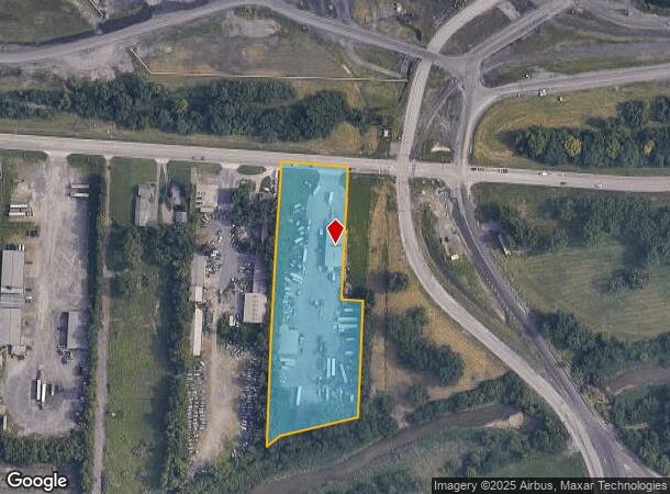
Property Record
2910 Oxford State Rd, Middletown, OH 45044
NEARBY LISTINGS FOR SALE OR LEASE
Property Detail
2910 Oxford State Rd
Cincinnati, OH-KY-IN
Garden Farms Sub
Q6542-099-000-013
18130 ENT
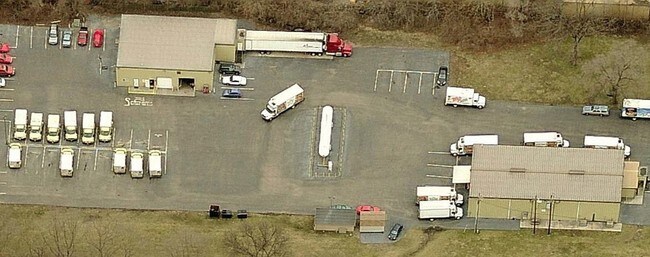
Warehouse
Butler
AE
Ohio
39017C0207E
12
2024
3.67 AC
2024
Monroe/Middletown
013900
Cincinnati/Dayton
11,094 SF
DEMOGRAPHICS near 2910 Oxford State Rd
1 Mile
3 Mile
5 Mile
2024 Total Population
1,051
44,784
98,514
2029 Population
1,075
45,817
101,025
Pop Growth 2024-2029
+ 2.28%
+ 2.31%
+ 2.55%
Average Age
36
39
39
2024 Total Households
367
17,800
37,879
HH Growth 2024-2029
+ 1.91%
+ 2.31%
+ 2.61%
Median Household Inc
$18,318
$51,291
$65,203
Avg Household Size
2.60
2.40
2.50
2024 Avg HH Vehicles
1.00
2.00
2.00
Median Home Value
$51,923
$142,523
$181,232
Median Year Built
1950
1965
1972
Nearby Places
Map Layers
Map Styles
 Street
 Aerial
- Restaurants
- Banks
- Shops
- Fitness
- Groceries
SALE & LEASE HISTORY
LISTING DATE
SALE/LEASE

Sep 23, 2016
For Sale
Mar 27, 2017
For Sale
Mar 21, 2017
For Sale
Mar 17, 2017
For Sale
Jul 12, 2017
For Lease
Nearby Properties
Address
Land Use
TOTAL SIZE
Lot Size
Zoning
Address
Land Use
TOTAL SIZE
Lot Size
Zoning
14,558 SF
26.81 AC
Address
Land Use
TOTAL SIZE
Lot Size
Zoning
34.66 AC
Address
Land Use
TOTAL SIZE
Lot Size
Zoning
369,922 SF
28.10 AC
Address
Land Use
TOTAL SIZE
Lot Size
Zoning
40.03 AC
Address
Land Use
TOTAL SIZE
Lot Size
Zoning
9,224 SF
16.21 AC
Address
Land Use
TOTAL SIZE
Lot Size
Zoning
833,210 SF
57.88 AC
Address
Land Use
TOTAL SIZE
Lot Size
Zoning
1,380,095 SF
47.11 AC
Address
Land Use
TOTAL SIZE
Lot Size
Zoning
3,956 SF
186.57 AC
Address
Land Use
TOTAL SIZE
Lot Size
Zoning
57.88 AC
Address
Land Use
TOTAL SIZE
Lot Size
Zoning
9,224 SF
16.21 AC
Address
Land Use
TOTAL SIZE
Lot Size
Zoning
334,640 SF
41.28 AC
Address
Land Use
TOTAL SIZE
Lot Size
Zoning
542,679 SF
24.92 AC
Address
Land Use
TOTAL SIZE
Lot Size
Zoning
369,922 SF
28.10 AC
Address
Land Use
TOTAL SIZE
Lot Size
Zoning
2,221 SF
7.84 AC
Address
Land Use
TOTAL SIZE
Lot Size
Zoning
189,571 SF
10.79 AC
ADV
Address
Land Use
TOTAL SIZE
Lot Size
Zoning
478,217 SF
61.13 AC
Address
Land Use
TOTAL SIZE
Lot Size
Zoning
14,325 SF
1.84 AC
Address
Land Use
TOTAL SIZE
Lot Size
Zoning
612,886 SF
30.51 AC
Address
Land Use
TOTAL SIZE
Lot Size
Zoning
148,762 SF
5.01 AC
Address
Land Use
TOTAL SIZE
Lot Size
Zoning
402,440 SF
25.46 AC
Address
Land Use
TOTAL SIZE
Lot Size
Zoning
93,289 SF
11.43 AC
Address
Land Use
TOTAL SIZE
Lot Size
Zoning
41.28 AC
Address
Land Use
TOTAL SIZE
Lot Size
Zoning
86.47 AC
ADV
Address
Land Use
TOTAL SIZE
Lot Size
Zoning
190,295 SF
21.70 AC
Address
Land Use
TOTAL SIZE
Lot Size
Zoning
57,248 SF
224.87 AC
Address
Land Use
TOTAL SIZE
Lot Size
Zoning
235,831 SF
15.01 AC
Address
Land Use
TOTAL SIZE
Lot Size
Zoning
113,241 SF
7.84 AC
Address
Land Use
TOTAL SIZE
Lot Size
Zoning
485,080 SF
15.10 AC
Address
Land Use
TOTAL SIZE
Lot Size
Zoning
Address
Land Use
TOTAL SIZE
Lot Size
Zoning
33,362 SF
0.73 AC
The World's #1 Commercial Real Estate Marketplace
Connect with us
© 2025 CoStar Group
The information above has been obtained from sources believed reliable. While we do not doubt its accuracy we have not verified it and make no guarantee, warranty or representation about it. It is your responsibility to independently confirm its accuracy and completeness. Any projections, opinions, assumptions, or estimates used are for example only and do not represent the current or future performance of the property. The value of this transaction to you depends on tax and other factors which should be evaluated by your tax, financial, and legal advisors. You and your advisors should conduct a careful, independent investigation of the property to determine to your satisfaction the suitability of the property for your needs.