Property Record
2909 Austell Rd Sw, Marietta, GA 30008

NEARBY LISTINGS FOR SALE OR LEASE
Property Detail
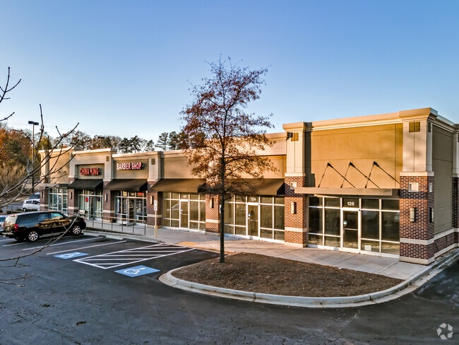
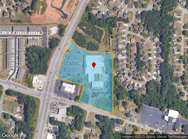
2909 Austell Rd Sw
19-0631-0-008-0
19Th District 2Nd Section
Regionalshoppingcenterormallwithanchorstore
Cobb
X
Georgia
13067C0114J
0
2025
6.30 AC
2025
Powder Spring/Austell
031005
Atlanta
46,404 SF
Atlanta-Sandy Springs-Roswell, GA
DEMOGRAPHICS near 2909 Austell Rd Sw
1 Mile
3 Mile
5 Mile
2024 Total Population
9,248
87,566
192,090
2029 Population
9,421
88,923
195,332
Pop Growth 2024-2029
+ 1.87%
+ 1.55%
+ 1.69%
Average Age
38
38
38
2024 Total Households
3,110
31,875
71,194
HH Growth 2024-2029
+ 1.90%
+ 1.51%
+ 1.65%
Median Household Inc
$83,944
$69,110
$76,661
Avg Household Size
2.80
2.60
2.60
2024 Avg HH Vehicles
2.00
2.00
2.00
Median Home Value
$248,463
$270,403
$301,423
Median Year Built
1988
1984
1985
Nearby Places
Map Layers
Map Styles
 Street
 Aerial
- Restaurants
- Banks
- Shops
- Fitness
- Groceries
PUBLIC TRANSPORTATION
AIRPORT
Hartsfield - Jackson Atlanta International
DRIVE
WALK
Distance
Hartsfield - Jackson Atlanta International
44 min
27.9 mi
SALE & LEASE HISTORY
LISTING DATE
SALE/LEASE

Sep 25, 2016
For Lease
Jul 31, 2019
For Lease
Nearby Properties
Address
Land Use
TOTAL SIZE
Lot Size
Zoning
Address
Land Use
TOTAL SIZE
Lot Size
Zoning
494,972 SF
25.60 AC
CF
Address
Land Use
TOTAL SIZE
Lot Size
Zoning
403,898 SF
37.53 AC
RM-12
Address
Land Use
TOTAL SIZE
Lot Size
Zoning
370,201 SF
28.35 AC
RM-12
Address
Land Use
TOTAL SIZE
Lot Size
Zoning
25,956 SF
12.78 AC
PVC
Address
Land Use
TOTAL SIZE
Lot Size
Zoning
272,170 SF
26.40 AC
RM-12
Address
Land Use
TOTAL SIZE
Lot Size
Zoning
488,748 SF
32.28 AC
RM-12
Address
Land Use
TOTAL SIZE
Lot Size
Zoning
285,190 SF
25.16 AC
RM-12
Address
Land Use
TOTAL SIZE
Lot Size
Zoning
225,315 SF
17.10 AC
RM-12
Address
Land Use
TOTAL SIZE
Lot Size
Zoning
238,984 SF
17.51 AC
RM-12
Address
Land Use
TOTAL SIZE
Lot Size
Zoning
236,808 SF
29.38 AC
PRD MF
Address
Land Use
TOTAL SIZE
Lot Size
Zoning
148,612 SF
12.65 AC
RM-12
Address
Land Use
TOTAL SIZE
Lot Size
Zoning
209,649 SF
13.51 AC
RM-12
Address
Land Use
TOTAL SIZE
Lot Size
Zoning
345,192 SF
22.67 AC
RM-12
Address
Land Use
TOTAL SIZE
Lot Size
Zoning
219,402 SF
10.33 AC
RM-12
Address
Land Use
TOTAL SIZE
Lot Size
Zoning
213,318 SF
19.28 AC
PRD MF
Address
Land Use
TOTAL SIZE
Lot Size
Zoning
160,030 SF
13.38 AC
RM-12
Address
Land Use
TOTAL SIZE
Lot Size
Zoning
179,048 SF
25.97 AC
RM-12
Address
Land Use
TOTAL SIZE
Lot Size
Zoning
217,980 SF
12.61 AC
PRD MF
Address
Land Use
TOTAL SIZE
Lot Size
Zoning
203,803 SF
14.63 AC
RM-12
Address
Land Use
TOTAL SIZE
Lot Size
Zoning
289,582 SF
21.01 AC
RM-12
Address
Land Use
TOTAL SIZE
Lot Size
Zoning
250,482 SF
16.74 AC
RM-12
Address
Land Use
TOTAL SIZE
Lot Size
Zoning
133,813 SF
10 AC
RM-12
Address
Land Use
TOTAL SIZE
Lot Size
Zoning
118,069 SF
0.38 AC
OI
Address
Land Use
TOTAL SIZE
Lot Size
Zoning
145,185 SF
13.52 AC
RM-12
Address
Land Use
TOTAL SIZE
Lot Size
Zoning
188,988 SF
15.30 AC
OI
Address
Land Use
TOTAL SIZE
Lot Size
Zoning
161,927 SF
7.95 AC
OI
Address
Land Use
TOTAL SIZE
Lot Size
Zoning
113,652 SF
9.40 AC
RM-12
Address
Land Use
TOTAL SIZE
Lot Size
Zoning
198,052 SF
24.52 AC
NRC/CRC
Address
Land Use
TOTAL SIZE
Lot Size
Zoning
131,802 SF
4.76 AC
RM-12
Address
Land Use
TOTAL SIZE
Lot Size
Zoning
105,892 SF
14.07 AC
NRC/WS
The World's #1 Commercial Real Estate Marketplace
Connect with us
© 2026 CoStar Group
The information above has been obtained from sources believed reliable. While we do not doubt its accuracy we have not verified it and make no guarantee, warranty or representation about it. It is your responsibility to independently confirm its accuracy and completeness. Any projections, opinions, assumptions, or estimates used are for example only and do not represent the current or future performance of the property. The value of this transaction to you depends on tax and other factors which should be evaluated by your tax, financial, and legal advisors. You and your advisors should conduct a careful, independent investigation of the property to determine to your satisfaction the suitability of the property for your needs.