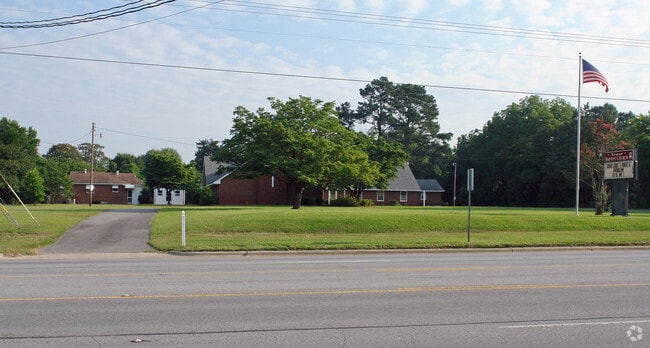
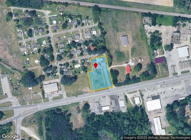
Property Record
2909 W Vernon Ave, Kinston, NC 28504
NEARBY LISTINGS FOR SALE OR LEASE
-
-
View all Kinston listings for sale on LoopNet.com
Property Detail
2909 W Vernon Ave
451509051229
NEUSE BAPTIST CHURCH EXEMPT PARCEL
Religious
Lenoir
X
North Carolina
3720450400K
1.50 AC
2025
North Carolina Southeast Area
2025
Other Market Areas
011001
Kinston, NC
1,968 SF
DEMOGRAPHICS near 2909 W Vernon Ave
1 Mile
3 Mile
5 Mile
2024 Total Population
614
15,998
29,957
2029 Population
609
15,802
29,756
Pop Growth 2024-2029
(0.81%)
(1.23%)
(0.67%)
Average Age
47
44
43
2024 Total Households
230
6,898
12,832
HH Growth 2024-2029
(0.87%)
(1.23%)
(0.66%)
Median Household Inc
$36,666
$40,120
$37,596
Avg Household Size
2.40
2.20
2.20
2024 Avg HH Vehicles
1.00
2.00
2.00
Median Home Value
$131,896
$125,766
$108,150
Median Year Built
1977
1971
1973
Nearby Places
Map Layers
Map Styles
 Street
 Aerial
- Restaurants
- Banks
- Shops
- Fitness
- Groceries
PUBLIC TRANSPORTATION
AIRPORT
Pitt-Greenville
DRIVE
WALK
Distance
Pitt-Greenville
47 min
32.6 mi
Albert J Ellis
DRIVE
WALK
Distance
Albert J Ellis
64 min
36.1 mi
Coastal Carolina Regional
DRIVE
WALK
Distance
Coastal Carolina Regional
52 min
40.6 mi
SALE & LEASE HISTORY
LISTING DATE
SALE/LEASE

Sep 24, 2016
For Sale
Dec 16, 2020
For Sale
Nearby Properties
Address
Land Use
TOTAL SIZE
Lot Size
Zoning
Address
Land Use
TOTAL SIZE
Lot Size
Zoning
216,063 SF
354.52 AC
I1
Address
Land Use
TOTAL SIZE
Lot Size
Zoning
274,824 SF
54.92 AC
OI
Address
Land Use
TOTAL SIZE
Lot Size
Zoning
22,420 SF
762.37 AC
RA6
Address
Land Use
TOTAL SIZE
Lot Size
Zoning
184,270 SF
980.52 AC
Address
Land Use
TOTAL SIZE
Lot Size
Zoning
99,724 SF
23.40 AC
Address
Land Use
TOTAL SIZE
Lot Size
Zoning
445,987 SF
957.24 AC
I1
Address
Land Use
TOTAL SIZE
Lot Size
Zoning
185,181 SF
12.24 AC
SC
Address
Land Use
TOTAL SIZE
Lot Size
Zoning
525,000 SF
384.32 AC
I1
Address
Land Use
TOTAL SIZE
Lot Size
Zoning
409,695 SF
25 AC
Address
Land Use
TOTAL SIZE
Lot Size
Zoning
107,460 SF
17.70 AC
I2
Address
Land Use
TOTAL SIZE
Lot Size
Zoning
202,946 SF
34.01 AC
I1
Address
Land Use
TOTAL SIZE
Lot Size
Zoning
247,376 SF
99.63 AC
I1
Address
Land Use
TOTAL SIZE
Lot Size
Zoning
64,008 SF
24 AC
I1
Address
Land Use
TOTAL SIZE
Lot Size
Zoning
191,518 SF
20.71 AC
SC
Address
Land Use
TOTAL SIZE
Lot Size
Zoning
45,675 SF
2.89 AC
IB
Address
Land Use
TOTAL SIZE
Lot Size
Zoning
118,696 SF
15.62 AC
IB
Address
Land Use
TOTAL SIZE
Lot Size
Zoning
234.71 AC
I1
Address
Land Use
TOTAL SIZE
Lot Size
Zoning
77,100 SF
1.91 AC
B2
Address
Land Use
TOTAL SIZE
Lot Size
Zoning
20,748 SF
33.22 AC
B1
Address
Land Use
TOTAL SIZE
Lot Size
Zoning
119,634 SF
1.86 AC
B2
Address
Land Use
TOTAL SIZE
Lot Size
Zoning
51,934 SF
0.32 AC
B2
Address
Land Use
TOTAL SIZE
Lot Size
Zoning
73,800 SF
5.38 AC
B1
Address
Land Use
TOTAL SIZE
Lot Size
Zoning
18,213 SF
159.12 AC
OI
Address
Land Use
TOTAL SIZE
Lot Size
Zoning
424,443 SF
104.04 AC
SC
Address
Land Use
TOTAL SIZE
Lot Size
Zoning
10,900 SF
9.14 AC
SC
Address
Land Use
TOTAL SIZE
Lot Size
Zoning
39,537 SF
1.58 AC
SC
Address
Land Use
TOTAL SIZE
Lot Size
Zoning
44,800 SF
9.75 AC
O&I
Address
Land Use
TOTAL SIZE
Lot Size
Zoning
78,420 SF
10 AC
I1
Address
Land Use
TOTAL SIZE
Lot Size
Zoning
108,816 SF
1.30 AC
B2
Address
Land Use
TOTAL SIZE
Lot Size
Zoning
11,270 SF
112 AC
RA6
The World's #1 Commercial Real Estate Marketplace
Connect with us
© 2025 CoStar Group
The information above has been obtained from sources believed reliable. While we do not doubt its accuracy we have not verified it and make no guarantee, warranty or representation about it. It is your responsibility to independently confirm its accuracy and completeness. Any projections, opinions, assumptions, or estimates used are for example only and do not represent the current or future performance of the property. The value of this transaction to you depends on tax and other factors which should be evaluated by your tax, financial, and legal advisors. You and your advisors should conduct a careful, independent investigation of the property to determine to your satisfaction the suitability of the property for your needs.