Property Record
291 Central Ave, Dover, NH 03820
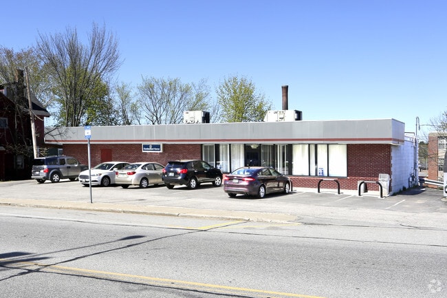

Property Detail
291 Central Ave
DOVR-002022
STRAFFORD
Officebuilding
New Hampshire
CBD-G
0.25 AC
B and X Area of moderate flood hazard, usually the area between the limits of the 100-year and 500-year floods.
Strafford County
2025
Boston
2025
Boston-Cambridge-Newton, MA-NH
081300
NEARBY LISTINGS FOR SALE OR LEASE
DEMOGRAPHICS near 291 Central Ave
1 mile
3 mile
5 mile
2025 Total Population
13,224
32,368
62,703
2030 Population
13,636
32,990
63,654
Pop Growth 2025-2030
+ 3.12%
+ 1.92%
+ 1.52%
Average Age
38
40
40
2025 Total Households
6,509
14,724
25,883
HH Growth 2025-2030
+ 3.30%
+ 2.10%
+ 1.67%
Median Household Inc
$77,678
$92,555
$93,439
Avg Household Size
2.00
2.10
2.30
2025 Avg HH Vehicles
2.00
2.00
2.00
Median Home Value
$468,278
$457,518
$430,319
Median Year Built
1960
1975
1973
Nearby Places
Map Layers
Map Styles
 Street
 Aerial
Layers
 Traffic
 Biking
Places
Listings with unknown addresses are not visible on the map
- Restaurants
- Banks
- Shops
- Fitness
- Groceries
PUBLIC TRANSPORTATION
AIRPORT
Portsmouth International at Pease
Drive
Walk
Distance
Portsmouth International at Pease
19 min
10.1 mi
Manchester Boston Regional
Drive
Walk
Distance
Manchester Boston Regional
68 min
44.3 mi
Portland International Jetport
Drive
Walk
Distance
Portland International Jetport
68 min
47.0 mi
SALE & LEASE HISTORY
LISTING DATE
SALE/LEASE

Jun 05, 2019
For Sale
Aug 08, 2019
For Sale
Nearby Properties
Address
Land Use
TOTAL SIZE
Lot Size
Zoning
Address
Land Use
TOTAL SIZE
Lot Size
Zoning
24.83 AC
R-20
Address
Land Use
TOTAL SIZE
Lot Size
Zoning
220.20 AC
IT
Address
Land Use
TOTAL SIZE
Lot Size
Zoning
1.26 AC
CBD-G
Address
Land Use
TOTAL SIZE
Lot Size
Zoning
20.03 AC
R-20
Address
Land Use
TOTAL SIZE
Lot Size
Zoning
7.84 AC
C
Address
Land Use
TOTAL SIZE
Lot Size
Zoning
3.66 AC
IT
Address
Land Use
TOTAL SIZE
Lot Size
Zoning
1.22 AC
CBD-G
Address
Land Use
TOTAL SIZE
Lot Size
Zoning
50.52 AC
RM-SU*
Address
Land Use
TOTAL SIZE
Lot Size
Zoning
18.65 AC
B
Address
Land Use
TOTAL SIZE
Lot Size
Zoning
3.40 AC
CBD-M
Address
Land Use
TOTAL SIZE
Lot Size
Zoning
19.55 AC
B
Address
Land Use
TOTAL SIZE
Lot Size
Zoning
11.80 AC
R-12*
Address
Land Use
TOTAL SIZE
Lot Size
Zoning
26.40 AC
IT*
Address
Land Use
TOTAL SIZE
Lot Size
Zoning
71.83 AC
R-40
Address
Land Use
TOTAL SIZE
Lot Size
Zoning
12.60 AC
IT
Address
Land Use
TOTAL SIZE
Lot Size
Zoning
3.35 AC
CBD-G
Address
Land Use
TOTAL SIZE
Lot Size
Zoning
7.92 AC
R-12
Address
Land Use
TOTAL SIZE
Lot Size
Zoning
0.22 AC
CBD-G
Address
Land Use
TOTAL SIZE
Lot Size
Zoning
4.15 AC
R-12
Address
Land Use
TOTAL SIZE
Lot Size
Zoning
11.08 AC
RM-U
Address
Land Use
TOTAL SIZE
Lot Size
Zoning
15.46 AC
C
Address
Land Use
TOTAL SIZE
Lot Size
Zoning
3.66 AC
C
Address
Land Use
TOTAL SIZE
Lot Size
Zoning
112,173 SF
21 AC
CI
Address
Land Use
TOTAL SIZE
Lot Size
Zoning
11.47 AC
IT
Address
Land Use
TOTAL SIZE
Lot Size
Zoning
197,921 SF
RC
Address
Land Use
TOTAL SIZE
Lot Size
Zoning
35.86 AC
R-40
Address
Land Use
TOTAL SIZE
Lot Size
Zoning
4.15 AC
RM-U
Address
Land Use
TOTAL SIZE
Lot Size
Zoning
15.46 AC
G
Address
Land Use
TOTAL SIZE
Lot Size
Zoning
9.29 AC
R-12*
Address
Land Use
TOTAL SIZE
Lot Size
Zoning
104,186 SF
21.50 AC
CI
The World's #1 Commercial Real Estate Marketplace
Connect with us
© 2026 CoStar Group
The information above has been obtained from sources believed reliable. While we do not doubt its accuracy we have not verified it and make no guarantee, warranty or representation about it. It is your responsibility to independently confirm its accuracy and completeness. Any projections, opinions, assumptions, or estimates used are for example only and do not represent the current or future performance of the property. The value of this transaction to you depends on tax and other factors which should be evaluated by your tax, financial, and legal advisors. You and your advisors should conduct a careful, independent investigation of the property to determine to your satisfaction the suitability of the property for your needs.