Property Record
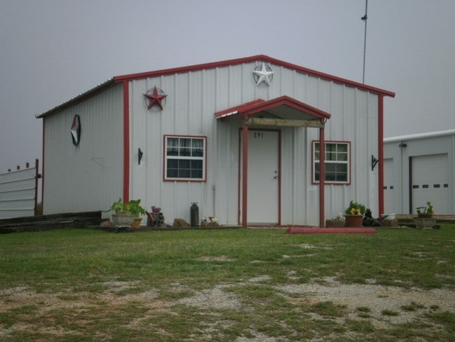
291 Morrow Rd, Springtown, TX 76082
Property Detail
291 Morrow Rd
R000078042
Mary Thomas Abs 1304
Commercialnec
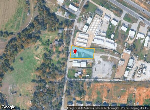
ACRES: 1.088 TR: BOW WOW, BLK:, SURV: MARY THOMAS
X
Parker
48497C0550D
Texas
2024
1.09 AC
2025
Parker County
140411
Dallas/Ft Worth
2,940 SF
Dallas-Fort Worth-Arlington, TX
NEARBY LISTINGS FOR SALE OR LEASE
DEMOGRAPHICS near 291 Morrow Rd
1 mile
3 mile
5 mile
2024 Total Population
1,336
12,865
26,675
2029 Population
1,721
16,609
34,435
Pop Growth 2024-2029
+ 28.82%
+ 29.10%
+ 29.09%
Average Age
41
40
40
2024 Total Households
494
4,654
9,508
HH Growth 2024-2029
+ 28.74%
+ 29.09%
+ 29.06%
Median Household Inc
$96,801
$72,842
$74,864
Avg Household Size
2.70
2.70
2.70
2024 Avg HH Vehicles
3.00
2.00
2.00
Median Home Value
$341,785
$254,705
$288,956
Median Year Built
2005
2001
2001
Nearby Places
Map Layers
Map Styles
 Street
 Aerial
Transit
 Traffic
 Biking
Places
Listings with unknown addresses are not visible on the map
- Restaurants
- Banks
- Shops
- Fitness
- Groceries
Nearby Properties
Address
Land Use
TOTAL SIZE
Lot Size
Zoning
Address
Land Use
TOTAL SIZE
Lot Size
Zoning
65,806 SF
5.83 AC
Address
Land Use
TOTAL SIZE
Lot Size
Zoning
114,024 SF
7.45 AC
Address
Land Use
TOTAL SIZE
Lot Size
Zoning
41,629 SF
4.66 AC
Address
Land Use
TOTAL SIZE
Lot Size
Zoning
49,110 SF
6.13 AC
Address
Land Use
TOTAL SIZE
Lot Size
Zoning
34,040 SF
14.75 AC
Address
Land Use
TOTAL SIZE
Lot Size
Zoning
585 SF
7.25 AC
Address
Land Use
TOTAL SIZE
Lot Size
Zoning
21,544 SF
2 AC
Address
Land Use
TOTAL SIZE
Lot Size
Zoning
50.42 AC
Address
Land Use
TOTAL SIZE
Lot Size
Zoning
9,608 SF
2 AC
Address
Land Use
TOTAL SIZE
Lot Size
Zoning
28,300 SF
2.10 AC
Address
Land Use
TOTAL SIZE
Lot Size
Zoning
Address
Land Use
TOTAL SIZE
Lot Size
Zoning
17,748 SF
5.55 AC
Address
Land Use
TOTAL SIZE
Lot Size
Zoning
20,628 SF
2 AC
Address
Land Use
TOTAL SIZE
Lot Size
Zoning
5,000 SF
7.73 AC
Address
Land Use
TOTAL SIZE
Lot Size
Zoning
900 SF
11.21 AC
Address
Land Use
TOTAL SIZE
Lot Size
Zoning
5,600 SF
1.98 AC
Address
Land Use
TOTAL SIZE
Lot Size
Zoning
15,354 SF
3 AC
Address
Land Use
TOTAL SIZE
Lot Size
Zoning
19,712 SF
0.28 AC
Address
Land Use
TOTAL SIZE
Lot Size
Zoning
4,000 SF
5.03 AC
Address
Land Use
TOTAL SIZE
Lot Size
Zoning
6,378 SF
9.16 AC
Address
Land Use
TOTAL SIZE
Lot Size
Zoning
14,300 SF
1.45 AC
Address
Land Use
TOTAL SIZE
Lot Size
Zoning
9,000 SF
9.99 AC
Address
Land Use
TOTAL SIZE
Lot Size
Zoning
1,256 SF
36.05 AC
Address
Land Use
TOTAL SIZE
Lot Size
Zoning
4,000 SF
3 AC
Address
Land Use
TOTAL SIZE
Lot Size
Zoning
33.61 AC
Address
Land Use
TOTAL SIZE
Lot Size
Zoning
15,000 SF
2.28 AC
Address
Land Use
TOTAL SIZE
Lot Size
Zoning
4,640 SF
1.68 AC
Address
Land Use
TOTAL SIZE
Lot Size
Zoning
9,142 SF
3.07 AC
Address
Land Use
TOTAL SIZE
Lot Size
Zoning
45,000 SF
9.88 AC
The World's #1 Commercial Real Estate Marketplace
Connect with us
© 2026 CoStar Group
The information above has been obtained from sources believed reliable. While we do not doubt its accuracy we have not verified it and make no guarantee, warranty or representation about it. It is your responsibility to independently confirm its accuracy and completeness. Any projections, opinions, assumptions, or estimates used are for example only and do not represent the current or future performance of the property. The value of this transaction to you depends on tax and other factors which should be evaluated by your tax, financial, and legal advisors. You and your advisors should conduct a careful, independent investigation of the property to determine to your satisfaction the suitability of the property for your needs.