Property Record
291 N 6Th Ave, Kingsburg, CA 93631

NEARBY LISTINGS FOR SALE OR LEASE
-
-
View all Kingsburg listings for sale on LoopNet.com
Property Detail
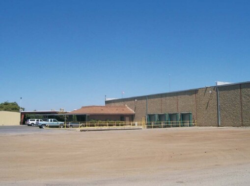
291 N 6Th Ave
Hanford-Corcoran, CA
Laguna De Tache Grants Secs 1
002-020-033-000
N 10 AC OF LOTS 25 & 26 SEC 2/17/22
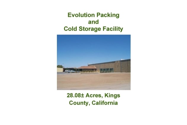
Packing
Kings
X
California
06019C2950J
25,26
2024
10 AC
2025
Outlying Kings County
000100
Fresno
DEMOGRAPHICS near 291 N 6Th Ave
1 Mile
3 Mile
5 Mile
2024 Total Population
209
9,432
18,159
2029 Population
206
9,725
18,577
Pop Growth 2024-2029
(1.44%)
+ 3.11%
+ 2.30%
Average Age
39
38
38
2024 Total Households
69
3,272
6,084
HH Growth 2024-2029
(1.45%)
+ 3.18%
+ 2.42%
Median Household Inc
$68,249
$67,628
$74,072
Avg Household Size
3.00
2.90
2.90
2024 Avg HH Vehicles
2.00
2.00
2.00
Median Home Value
$494,444
$311,090
$362,423
Median Year Built
1982
1985
1984
Nearby Places
Map Layers
Map Styles
 Street
 Aerial
- Restaurants
- Banks
- Shops
- Fitness
- Groceries
PUBLIC TRANSPORTATION
AIRPORT
Fresno Yosemite International
DRIVE
WALK
Distance
Fresno Yosemite International
37 min
25.8 mi
Freight Ports
Port of Stockton
DRIVE
WALK
Distance
Port of Stockton
178 min
150.9 mi
Nearby Properties
Address
Land Use
TOTAL SIZE
Lot Size
Zoning
Address
Land Use
TOTAL SIZE
Lot Size
Zoning
34.31 AC
Address
Land Use
TOTAL SIZE
Lot Size
Zoning
49,061 SF
11.22 AC
CC
Address
Land Use
TOTAL SIZE
Lot Size
Zoning
181.35 AC
AE20
Address
Land Use
TOTAL SIZE
Lot Size
Zoning
314,498 SF
14.99 AC
IL
Address
Land Use
TOTAL SIZE
Lot Size
Zoning
43,200 SF
1.99 AC
CH
Address
Land Use
TOTAL SIZE
Lot Size
Zoning
109,547 SF
2.61 AC
M1
Address
Land Use
TOTAL SIZE
Lot Size
Zoning
41,517 SF
4.32 AC
CH
Address
Land Use
TOTAL SIZE
Lot Size
Zoning
31,597 SF
1.38 AC
C3
Address
Land Use
TOTAL SIZE
Lot Size
Zoning
15,808 SF
2.42 AC
CC
Address
Land Use
TOTAL SIZE
Lot Size
Zoning
43,914 SF
19.20 AC
Address
Land Use
TOTAL SIZE
Lot Size
Zoning
14,474 SF
1.82 AC
CC
Address
Land Use
TOTAL SIZE
Lot Size
Zoning
21,031 SF
1.34 AC
CH
Address
Land Use
TOTAL SIZE
Lot Size
Zoning
17,808 SF
2.08 AC
C3
Address
Land Use
TOTAL SIZE
Lot Size
Zoning
15,805 SF
1.67 AC
CH
Address
Land Use
TOTAL SIZE
Lot Size
Zoning
1,926 SF
37.89 AC
AE20
Address
Land Use
TOTAL SIZE
Lot Size
Zoning
19,645 SF
0.28 AC
C2
Address
Land Use
TOTAL SIZE
Lot Size
Zoning
8,400 SF
0.95 AC
M1
Address
Land Use
TOTAL SIZE
Lot Size
Zoning
100,676 SF
7.97 AC
CH
Address
Land Use
TOTAL SIZE
Lot Size
Zoning
17,670 SF
0.91 AC
CH
Address
Land Use
TOTAL SIZE
Lot Size
Zoning
21,122 SF
1.90 AC
CC
Address
Land Use
TOTAL SIZE
Lot Size
Zoning
82,129 SF
4.36 AC
AL20
Address
Land Use
TOTAL SIZE
Lot Size
Zoning
18.08 AC
AG20
Address
Land Use
TOTAL SIZE
Lot Size
Zoning
6,466 SF
0.94 AC
CC
Address
Land Use
TOTAL SIZE
Lot Size
Zoning
864 SF
112.30 AC
AG20
Address
Land Use
TOTAL SIZE
Lot Size
Zoning
5,355 SF
0.72 AC
CC
Address
Land Use
TOTAL SIZE
Lot Size
Zoning
5,641 SF
21.48 AC
AG20
Address
Land Use
TOTAL SIZE
Lot Size
Zoning
23,384 SF
1.34 AC
CH
Address
Land Use
TOTAL SIZE
Lot Size
Zoning
6,800 SF
0.69 AC
CC
Address
Land Use
TOTAL SIZE
Lot Size
Zoning
10,000 SF
0.80 AC
CH
The World's #1 Commercial Real Estate Marketplace
Connect with us
© 2026 CoStar Group
The information above has been obtained from sources believed reliable. While we do not doubt its accuracy we have not verified it and make no guarantee, warranty or representation about it. It is your responsibility to independently confirm its accuracy and completeness. Any projections, opinions, assumptions, or estimates used are for example only and do not represent the current or future performance of the property. The value of this transaction to you depends on tax and other factors which should be evaluated by your tax, financial, and legal advisors. You and your advisors should conduct a careful, independent investigation of the property to determine to your satisfaction the suitability of the property for your needs.