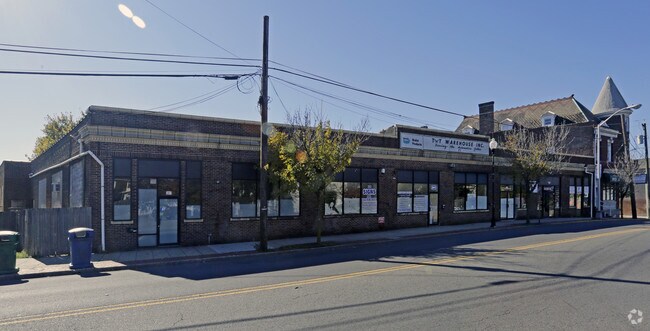
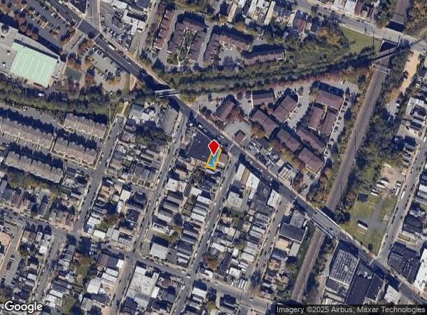
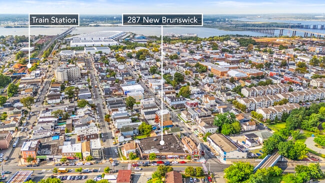
Property Record
287 New Brunswick Ave, Perth Amboy, NJ 08861

Current Lease Availabilities
General Retail LEASE
$16.46 - $27.05 SF/YR
976 - 2,996 SF
NEARBY LISTINGS FOR SALE OR LEASE
Property Detail
287 New Brunswick Ave
New York-Jersey City-White Plains, NY-NJ
Incl
16-00158-0000-00019
135X103 & 33X100 17,19.01,20,21,22,23
Commercialnec
Middlesex
X
New Jersey
34023C0069F
19
2024
0.20 AC
2025
South Edison
004700
Northern New Jersey
19,156 SF
DEMOGRAPHICS near 287 New Brunswick Ave
1 Mile
3 Mile
5 Mile
2024 Total Population
40,621
103,557
271,870
2029 Population
38,982
101,351
267,808
Pop Growth 2024-2029
(4.03%)
(2.13%)
(1.49%)
Average Age
36
39
40
2024 Total Households
12,428
35,487
96,964
HH Growth 2024-2029
(3.99%)
(2.03%)
(1.49%)
Median Household Inc
$48,906
$73,937
$90,684
Avg Household Size
3.10
2.80
2.70
2024 Avg HH Vehicles
1.00
2.00
2.00
Median Home Value
$288,953
$371,057
$403,029
Median Year Built
1952
1961
1970
Nearby Places
- Restaurants
- Banks
- Shops
- Fitness
- Groceries
PUBLIC TRANSPORTATION
TRANSIT/SUBWAY
Perth Amboy (North Jersey Coast Line - NJ Transit Commuter Rail (NJ Transit))
DRIVE
WALK
Distance
Perth Amboy (North Jersey Coast Line - NJ Transit Commuter Rail (NJ Transit))
2 min
8 min
0.4 mi
COMMUTER RAIL
Perth Amboy (North Jersey Coast Line - NJ Transit Commuter Rail (NJ Transit))
DRIVE
WALK
Distance
Perth Amboy (North Jersey Coast Line - NJ Transit Commuter Rail (NJ Transit))
2 min
8 min
0.4 mi
Richmond Valley (Staten Island Railway - New York MTA Subway (The Subway))
DRIVE
WALK
Distance
Richmond Valley (Staten Island Railway - New York MTA Subway (The Subway))
8 min
3.8 mi
AIRPORT
Newark Liberty International
DRIVE
WALK
Distance
Newark Liberty International
30 min
19.7 mi
LaGuardia
DRIVE
WALK
Distance
LaGuardia
59 min
35.7 mi
John F Kennedy International
DRIVE
WALK
Distance
John F Kennedy International
58 min
38.4 mi
Freight Ports
New York Container Terminal
DRIVE
WALK
Distance
New York Container Terminal
20 min
12.8 mi
Nearby Properties
Address
Land Use
TOTAL SIZE
Lot Size
Zoning
Address
Land Use
TOTAL SIZE
Lot Size
Zoning
1,889 SF
235.62 AC
Address
Land Use
TOTAL SIZE
Lot Size
Zoning
37.32 AC
S-3B
Address
Land Use
TOTAL SIZE
Lot Size
Zoning
Address
Land Use
TOTAL SIZE
Lot Size
Zoning
53.04 AC
S-1F
Address
Land Use
TOTAL SIZE
Lot Size
Zoning
11.63 AC
S-3D
Address
Land Use
TOTAL SIZE
Lot Size
Zoning
10.69 AC
R-MM
Address
Land Use
TOTAL SIZE
Lot Size
Zoning
15.15 AC
RMMF
Address
Land Use
TOTAL SIZE
Lot Size
Zoning
71.66 AC
M-3
Address
Land Use
TOTAL SIZE
Lot Size
Zoning
2.14 AC
C-4
Address
Land Use
TOTAL SIZE
Lot Size
Zoning
2.51 AC
H
Address
Land Use
TOTAL SIZE
Lot Size
Zoning
28.90 AC
S-3B
Address
Land Use
TOTAL SIZE
Lot Size
Zoning
52.97 AC
M-3
Address
Land Use
TOTAL SIZE
Lot Size
Zoning
64.66 AC
S-3A
Address
Land Use
TOTAL SIZE
Lot Size
Zoning
6.79 AC
R-50
Address
Land Use
TOTAL SIZE
Lot Size
Zoning
7.23 AC
S-2A
Address
Land Use
TOTAL SIZE
Lot Size
Zoning
27.36 AC
Address
Land Use
TOTAL SIZE
Lot Size
Zoning
6,822 SF
29.22 AC
S-2C
Address
Land Use
TOTAL SIZE
Lot Size
Zoning
39.14 AC
M-3
Address
Land Use
TOTAL SIZE
Lot Size
Zoning
90.33 AC
Address
Land Use
TOTAL SIZE
Lot Size
Zoning
276 SF
6.59 AC
S-2A
Address
Land Use
TOTAL SIZE
Lot Size
Zoning
23.01 AC
S-1F
Address
Land Use
TOTAL SIZE
Lot Size
Zoning
35.05 AC
M-3
Address
Land Use
TOTAL SIZE
Lot Size
Zoning
15,000 SF
16.63 AC
M1-1
Address
Land Use
TOTAL SIZE
Lot Size
Zoning
64.66 AC
S-3A
Address
Land Use
TOTAL SIZE
Lot Size
Zoning
9.72 AC
M-1
Address
Land Use
TOTAL SIZE
Lot Size
Zoning
135,000 SF
4.54 AC
R3X
Address
Land Use
TOTAL SIZE
Lot Size
Zoning
60.44 AC
S-3A
Address
Land Use
TOTAL SIZE
Lot Size
Zoning
317 SF
11.60 AC
R-MM
Address
Land Use
TOTAL SIZE
Lot Size
Zoning
15.55 AC
Address
Land Use
TOTAL SIZE
Lot Size
Zoning
3.29 AC
M1
The World's #1 Commercial Real Estate Marketplace
Connect with us
© 2025 CoStar Group
The information above has been obtained from sources believed reliable. While we do not doubt its accuracy we have not verified it and make no guarantee, warranty or representation about it. It is your responsibility to independently confirm its accuracy and completeness. Any projections, opinions, assumptions, or estimates used are for example only and do not represent the current or future performance of the property. The value of this transaction to you depends on tax and other factors which should be evaluated by your tax, financial, and legal advisors. You and your advisors should conduct a careful, independent investigation of the property to determine to your satisfaction the suitability of the property for your needs.