Property Record
291 Route 513, Lebanon, NJ 08833
NEARBY LISTINGS FOR SALE OR LEASE
Property Detail
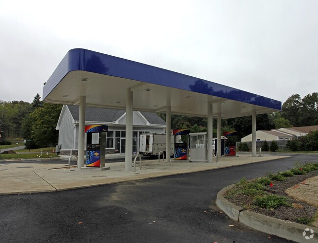
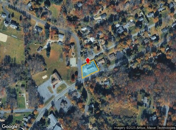
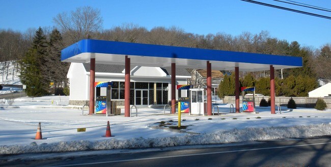
291 Route 513
19-00025-0000-00011
ADDITIONAL LOTS: 12
Servicestation
Hunterdon
X
New Jersey
34019C0109F
11
2024
0.66 AC
2025
Route 78 West
010802
Northern New Jersey
1,032 SF
Newark, NJ-PA
DEMOGRAPHICS near 291 Route 513
1 Mile
3 Mile
5 Mile
2024 Total Population
854
11,103
28,997
2029 Population
864
11,223
29,366
Pop Growth 2024-2029
+ 1.17%
+ 1.08%
+ 1.27%
Average Age
46
42
43
2024 Total Households
359
4,053
10,959
HH Growth 2024-2029
+ 1.39%
+ 1.26%
+ 1.44%
Median Household Inc
$135,526
$120,987
$122,928
Avg Household Size
2.40
2.50
2.50
2024 Avg HH Vehicles
2.00
2.00
2.00
Median Home Value
$465,178
$378,164
$414,888
Median Year Built
1972
1971
1975
Nearby Places
Map Layers
Map Styles
 Street
 Aerial
- Restaurants
- Banks
- Shops
- Fitness
- Groceries
PUBLIC TRANSPORTATION
COMMUTER RAIL
High Bridge (Raritan Valley Line - NJ Transit Commuter Rail (NJ Transit))
DRIVE
WALK
Distance
High Bridge (Raritan Valley Line - NJ Transit Commuter Rail (NJ Transit))
4 min
2.7 mi
Annandale (Raritan Valley Line - NJ Transit Commuter Rail (NJ Transit))
DRIVE
WALK
Distance
Annandale (Raritan Valley Line - NJ Transit Commuter Rail (NJ Transit))
11 min
4.8 mi
AIRPORT
Trenton Mercer
DRIVE
WALK
Distance
Trenton Mercer
54 min
35.8 mi
Lehigh Valley International
DRIVE
WALK
Distance
Lehigh Valley International
57 min
37.7 mi
Freight Ports
New York Container Terminal
DRIVE
WALK
Distance
New York Container Terminal
68 min
51.3 mi
Nearby Properties
Address
Land Use
TOTAL SIZE
Lot Size
Zoning
Address
Land Use
TOTAL SIZE
Lot Size
Zoning
56.97 AC
R3
Address
Land Use
TOTAL SIZE
Lot Size
Zoning
215.75 AC
RC
Address
Land Use
TOTAL SIZE
Lot Size
Zoning
59,942 SF
20.09 AC
R-5
Address
Land Use
TOTAL SIZE
Lot Size
Zoning
26.52 AC
RC
Address
Land Use
TOTAL SIZE
Lot Size
Zoning
52,594 SF
4.58 AC
GA
Address
Land Use
TOTAL SIZE
Lot Size
Zoning
34.80 AC
ROM
Address
Land Use
TOTAL SIZE
Lot Size
Zoning
2,544 SF
562.37 AC
RC
Address
Land Use
TOTAL SIZE
Lot Size
Zoning
16,580 SF
25.53 AC
RC
Address
Land Use
TOTAL SIZE
Lot Size
Zoning
14,526 SF
5.03 AC
R-2A
Address
Land Use
TOTAL SIZE
Lot Size
Zoning
22.94 AC
R-2
Address
Land Use
TOTAL SIZE
Lot Size
Zoning
25,440 SF
6.06 AC
B2
Address
Land Use
TOTAL SIZE
Lot Size
Zoning
19,905 SF
1.92 AC
R-3
Address
Land Use
TOTAL SIZE
Lot Size
Zoning
73.40 AC
G
Address
Land Use
TOTAL SIZE
Lot Size
Zoning
2,368 SF
227.39 AC
R3
Address
Land Use
TOTAL SIZE
Lot Size
Zoning
32,049 SF
3.99 AC
B1
Address
Land Use
TOTAL SIZE
Lot Size
Zoning
1,520 SF
302.94 AC
RC
Address
Land Use
TOTAL SIZE
Lot Size
Zoning
2.20 AC
R-4
Address
Land Use
TOTAL SIZE
Lot Size
Zoning
6,080 SF
37.09 AC
RC
Address
Land Use
TOTAL SIZE
Lot Size
Zoning
28,530 SF
3.09 AC
HB
Address
Land Use
TOTAL SIZE
Lot Size
Zoning
4,443 SF
5.43 AC
MUC
Address
Land Use
TOTAL SIZE
Lot Size
Zoning
7,640 SF
1.87 AC
R1.5
Address
Land Use
TOTAL SIZE
Lot Size
Zoning
3.10 AC
C
Address
Land Use
TOTAL SIZE
Lot Size
Zoning
19,209 SF
2.25 AC
HL
Address
Land Use
TOTAL SIZE
Lot Size
Zoning
10,698 SF
2.35 AC
B1
Address
Land Use
TOTAL SIZE
Lot Size
Zoning
35 AC
I
Address
Land Use
TOTAL SIZE
Lot Size
Zoning
0.81 AC
DB
Address
Land Use
TOTAL SIZE
Lot Size
Zoning
2,738 SF
2.13 AC
HB
Address
Land Use
TOTAL SIZE
Lot Size
Zoning
12,000 SF
3.70 AC
B2
Address
Land Use
TOTAL SIZE
Lot Size
Zoning
12,528 SF
14.83 AC
B1
Address
Land Use
TOTAL SIZE
Lot Size
Zoning
5,684 SF
5.08 AC
R1.5
The World's #1 Commercial Real Estate Marketplace
Connect with us
© 2025 CoStar Group
The information above has been obtained from sources believed reliable. While we do not doubt its accuracy we have not verified it and make no guarantee, warranty or representation about it. It is your responsibility to independently confirm its accuracy and completeness. Any projections, opinions, assumptions, or estimates used are for example only and do not represent the current or future performance of the property. The value of this transaction to you depends on tax and other factors which should be evaluated by your tax, financial, and legal advisors. You and your advisors should conduct a careful, independent investigation of the property to determine to your satisfaction the suitability of the property for your needs.