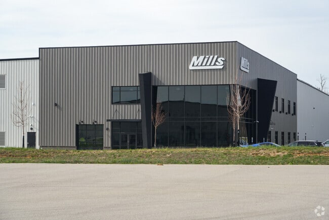
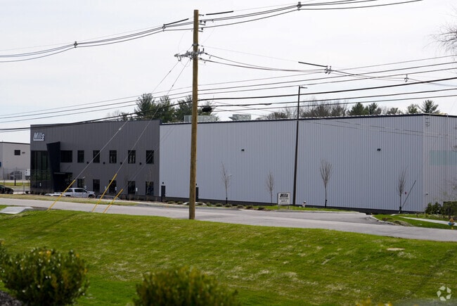
Property Record
2910 Blankenbaker Rd, Louisville, KY 40299

NEARBY LISTINGS FOR SALE OR LEASE
Property Detail
2910 Blankenbaker Rd
003910540000
9.76 AC TRACT 2 DB 12457X809
Warehouse
Jefferson
X
Kentucky
21111C0064F
8.23 AC
2025
Southeast
2025
Louisville
011116
Louisville-Jefferson County, KY-IN
DEMOGRAPHICS near 2910 Blankenbaker Rd
1 Mile
3 Mile
5 Mile
2024 Total Population
1,363
50,891
137,706
2029 Population
1,359
50,148
135,565
Pop Growth 2024-2029
(0.29%)
(1.46%)
(1.55%)
Average Age
43
41
41
2024 Total Households
585
21,160
57,922
HH Growth 2024-2029
(0.51%)
(1.50%)
(1.57%)
Median Household Inc
$74,409
$82,788
$83,014
Avg Household Size
2.30
2.40
2.30
2024 Avg HH Vehicles
2.00
2.00
2.00
Median Home Value
$316,529
$270,168
$269,113
Median Year Built
2003
1981
1982
Nearby Places
Map Layers
Map Styles
 Street
 Aerial
- Restaurants
- Banks
- Shops
- Fitness
- Groceries
PUBLIC TRANSPORTATION
AIRPORT
Louisville Muhammad Ali International
DRIVE
WALK
Distance
Louisville Muhammad Ali International
30 min
18.7 mi
Freight Ports
Port of Toledo
DRIVE
WALK
Distance
Port of Toledo
355 min
302.5 mi
Nearby Properties
Address
Land Use
TOTAL SIZE
Lot Size
Zoning
Address
Land Use
TOTAL SIZE
Lot Size
Zoning
115.43 AC
R4-RESIDEN
Address
Land Use
TOTAL SIZE
Lot Size
Zoning
2,776 SF
34.17 AC
R4-RESIDEN
Address
Land Use
TOTAL SIZE
Lot Size
Zoning
1,194 SF
38.74 AC
R4-RESIDEN
Address
Land Use
TOTAL SIZE
Lot Size
Zoning
1,334 SF
24.71 AC
R4-RESIDEN
Address
Land Use
TOTAL SIZE
Lot Size
Zoning
8.47 AC
R1-RESIDEN
Address
Land Use
TOTAL SIZE
Lot Size
Zoning
45.92 AC
Address
Land Use
TOTAL SIZE
Lot Size
Zoning
19.57 AC
Address
Land Use
TOTAL SIZE
Lot Size
Zoning
202,557 SF
6.06 AC
C2-COMMERC
Address
Land Use
TOTAL SIZE
Lot Size
Zoning
31,968 SF
15.34 AC
R4-RESIDEN
Address
Land Use
TOTAL SIZE
Lot Size
Zoning
175,971 SF
18.54 AC
PEC-PLANNE
Address
Land Use
TOTAL SIZE
Lot Size
Zoning
19,568 SF
24.23 AC
R7-RESIDEN
Address
Land Use
TOTAL SIZE
Lot Size
Zoning
9,560 SF
20.31 AC
C1-COMMERC
Address
Land Use
TOTAL SIZE
Lot Size
Zoning
18,784 SF
16.80 AC
R6-RESIDEN
Address
Land Use
TOTAL SIZE
Lot Size
Zoning
28.91 AC
R4-RESIDEN
Address
Land Use
TOTAL SIZE
Lot Size
Zoning
335,400 SF
18.84 AC
PEC-PLANNE
Address
Land Use
TOTAL SIZE
Lot Size
Zoning
19.91 AC
Address
Land Use
TOTAL SIZE
Lot Size
Zoning
Address
Land Use
TOTAL SIZE
Lot Size
Zoning
Address
Land Use
TOTAL SIZE
Lot Size
Zoning
2,665 SF
6.72 AC
R4-RESIDEN
Address
Land Use
TOTAL SIZE
Lot Size
Zoning
159,847 SF
5.23 AC
PEC-PLANNE
Address
Land Use
TOTAL SIZE
Lot Size
Zoning
110,088 SF
8.69 AC
PEC-PLANNE
Address
Land Use
TOTAL SIZE
Lot Size
Zoning
10,358 SF
17.01 AC
R6-RESIDEN
Address
Land Use
TOTAL SIZE
Lot Size
Zoning
51,076 SF
9.77 AC
OR3-OFFICE
Address
Land Use
TOTAL SIZE
Lot Size
Zoning
30.45 AC
Address
Land Use
TOTAL SIZE
Lot Size
Zoning
10.44 AC
PEC-PLANNE
Address
Land Use
TOTAL SIZE
Lot Size
Zoning
48,000 SF
29.85 AC
PEC-PLANNE
Address
Land Use
TOTAL SIZE
Lot Size
Zoning
13,810 SF
12.69 AC
R6-RESIDEN
Address
Land Use
TOTAL SIZE
Lot Size
Zoning
98,442 SF
21.16 AC
C2-COMMERC
Address
Land Use
TOTAL SIZE
Lot Size
Zoning
720 SF
12.82 AC
R6-RESIDEN
Address
Land Use
TOTAL SIZE
Lot Size
Zoning
103,520 SF
24.91 AC
The World's #1 Commercial Real Estate Marketplace
Connect with us
© 2026 CoStar Group
The information above has been obtained from sources believed reliable. While we do not doubt its accuracy we have not verified it and make no guarantee, warranty or representation about it. It is your responsibility to independently confirm its accuracy and completeness. Any projections, opinions, assumptions, or estimates used are for example only and do not represent the current or future performance of the property. The value of this transaction to you depends on tax and other factors which should be evaluated by your tax, financial, and legal advisors. You and your advisors should conduct a careful, independent investigation of the property to determine to your satisfaction the suitability of the property for your needs.