Property Record
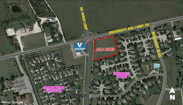
2910 E University Ave, Georgetown, TX 78626

Property Detail
2910 E University Ave
Austin-Round Rock-San Marcos, TX
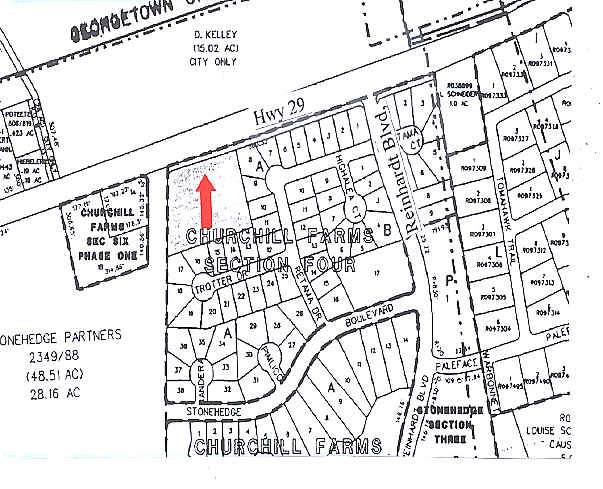
CHURCHILL FARMS SEC 4, BLOCK A, LOT 39, ACRES 2.219
R357868
WILLIAMSON
Commercialacreage
Texas
B and X Area of moderate flood hazard, usually the area between the limits of the 100-year and 500-year floods.
39
2024
2.22 AC
2025
Georgetown
020822
Austin
NEARBY LISTINGS FOR SALE OR LEASE
DEMOGRAPHICS near 2910 E University Ave
1 mile
3 mile
5 mile
2024 Total Population
7,665
42,676
89,849
2029 Population
8,846
49,675
104,483
Pop Growth 2024-2029
+ 15.41%
+ 16.40%
+ 16.29%
Average Age
36
37
39
2024 Total Households
2,508
15,479
34,346
HH Growth 2024-2029
+ 15.99%
+ 17.04%
+ 16.86%
Median Household Inc
$113,736
$91,215
$102,530
Avg Household Size
3.00
2.60
2.50
2024 Avg HH Vehicles
2.00
2.00
2.00
Median Home Value
$380,035
$387,665
$448,518
Median Year Built
2006
2007
2010
Nearby Places
Map Layers
Map Styles
 Street
 Aerial
Transit
 Traffic
 Biking
Places
Listings with unknown addresses are not visible on the map
- Restaurants
- Banks
- Shops
- Fitness
- Groceries
PUBLIC TRANSPORTATION
AIRPORT
Austin-Bergstrom International
Drive
Walk
Distance
Austin-Bergstrom International
47 min
40.5 mi
Killeen Municipal
Drive
Walk
Distance
Killeen Municipal
53 min
41.0 mi
Robert Gray AAF
Drive
Walk
Distance
Robert Gray AAF
57 min
42.8 mi
SALE & LEASE HISTORY
LISTING DATE
SALE/LEASE

Sep 24, 2016
For Sale
Nearby Properties
Address
Land Use
TOTAL SIZE
Lot Size
Zoning
Address
Land Use
TOTAL SIZE
Lot Size
Zoning
71.65 AC
1-RS
Address
Land Use
TOTAL SIZE
Lot Size
Zoning
145,000 SF
147.12 AC
Address
Land Use
TOTAL SIZE
Lot Size
Zoning
453,015 SF
22.62 AC
Address
Land Use
TOTAL SIZE
Lot Size
Zoning
294,214 SF
18.34 AC
Address
Land Use
TOTAL SIZE
Lot Size
Zoning
228,685 SF
10.32 AC
Address
Land Use
TOTAL SIZE
Lot Size
Zoning
252,492 SF
15.35 AC
Address
Land Use
TOTAL SIZE
Lot Size
Zoning
316,931 SF
3.02 AC
Address
Land Use
TOTAL SIZE
Lot Size
Zoning
314,240 SF
16.03 AC
Address
Land Use
TOTAL SIZE
Lot Size
Zoning
238,704 SF
19.85 AC
Address
Land Use
TOTAL SIZE
Lot Size
Zoning
205,554 SF
12.13 AC
3-C-3
Address
Land Use
TOTAL SIZE
Lot Size
Zoning
8,727 SF
89.67 AC
Address
Land Use
TOTAL SIZE
Lot Size
Zoning
49.39 AC
Address
Land Use
TOTAL SIZE
Lot Size
Zoning
186,337 SF
8.39 AC
Address
Land Use
TOTAL SIZE
Lot Size
Zoning
610,222 SF
10.16 AC
Address
Land Use
TOTAL SIZE
Lot Size
Zoning
176,875 SF
14.75 AC
3-C-1
Address
Land Use
TOTAL SIZE
Lot Size
Zoning
96,760 SF
9.04 AC
2-I
Address
Land Use
TOTAL SIZE
Lot Size
Zoning
155,674 SF
10.96 AC
Address
Land Use
TOTAL SIZE
Lot Size
Zoning
154,603 SF
20.04 AC
Address
Land Use
TOTAL SIZE
Lot Size
Zoning
121,117 SF
12.04 AC
Address
Land Use
TOTAL SIZE
Lot Size
Zoning
125,100 SF
4.39 AC
Address
Land Use
TOTAL SIZE
Lot Size
Zoning
2,460 SF
21.69 AC
Address
Land Use
TOTAL SIZE
Lot Size
Zoning
167,139 SF
10.35 AC
Address
Land Use
TOTAL SIZE
Lot Size
Zoning
162,236 SF
8.99 AC
Address
Land Use
TOTAL SIZE
Lot Size
Zoning
116,641 SF
5.93 AC
Address
Land Use
TOTAL SIZE
Lot Size
Zoning
49,000 SF
0.67 AC
Address
Land Use
TOTAL SIZE
Lot Size
Zoning
168,572 SF
10.73 AC
Address
Land Use
TOTAL SIZE
Lot Size
Zoning
118,480 SF
10.23 AC
Address
Land Use
TOTAL SIZE
Lot Size
Zoning
138,540 SF
7.38 AC
Address
Land Use
TOTAL SIZE
Lot Size
Zoning
27.61 AC
Address
Land Use
TOTAL SIZE
Lot Size
Zoning
184,242 SF
11 AC
The World's #1 Commercial Real Estate Marketplace
Connect with us
© 2026 CoStar Group
The information above has been obtained from sources believed reliable. While we do not doubt its accuracy we have not verified it and make no guarantee, warranty or representation about it. It is your responsibility to independently confirm its accuracy and completeness. Any projections, opinions, assumptions, or estimates used are for example only and do not represent the current or future performance of the property. The value of this transaction to you depends on tax and other factors which should be evaluated by your tax, financial, and legal advisors. You and your advisors should conduct a careful, independent investigation of the property to determine to your satisfaction the suitability of the property for your needs.