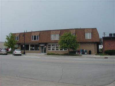
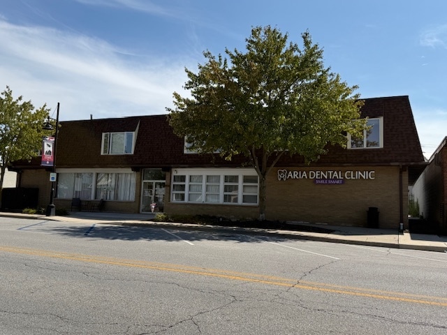
Property Record
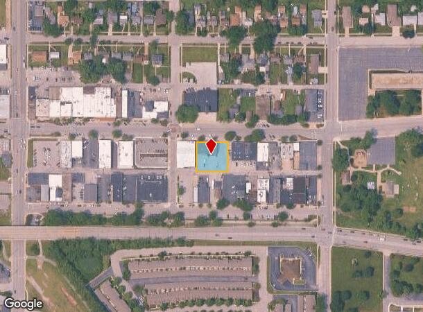
2910 Highway Ave, Highland, IN 46322
This Property Is For Sale
NEARBY LISTINGS FOR SALE OR LEASE
Property Detail
2910 Highway Ave
Chicago-Naperville-Elgin, IL-IN-WI
Burns Resub
45-07-21-452-004.000-026
BURNS RESUB. BL.21 HIGHLAND LOTS 2,3 & 4 EX. E.25FT OF LOT 4
Medicalbuilding
Lake
X
Indiana
18089C0137F
2,3,4
2024
0.38 AC
2025
Indiana
040801
Chicago
12,420 SF
DEMOGRAPHICS near 2910 Highway Ave
1 Mile
3 Mile
5 Mile
2024 Total Population
11,366
87,139
194,967
2029 Population
11,210
86,510
193,675
Pop Growth 2024-2029
(1.37%)
(0.72%)
(0.66%)
Average Age
42
41
40
2024 Total Households
4,658
35,006
76,747
HH Growth 2024-2029
(1.40%)
(0.76%)
(0.72%)
Median Household Inc
$69,026
$66,646
$61,626
Avg Household Size
2.40
2.40
2.50
2024 Avg HH Vehicles
2.00
2.00
2.00
Median Home Value
$182,730
$190,900
$178,005
Median Year Built
1956
1962
1963
Nearby Places
Map Layers
Map Styles
 Street
 Aerial
- Restaurants
- Banks
- Shops
- Fitness
- Groceries
PUBLIC TRANSPORTATION
COMMUTER RAIL
Dyer Amtrak (Cardinal - Amtrak)
DRIVE
WALK
Distance
Dyer Amtrak (Cardinal - Amtrak)
13 min
6.3 mi
AIRPORT
Chicago Midway International
DRIVE
WALK
Distance
Chicago Midway International
45 min
29.4 mi
Freight Ports
Port Milwaukee
DRIVE
WALK
Distance
Port Milwaukee
148 min
115.9 mi
Nearby Properties
Address
Land Use
TOTAL SIZE
Lot Size
Zoning
Address
Land Use
TOTAL SIZE
Lot Size
Zoning
879,191 SF
13.93 AC
Address
Land Use
TOTAL SIZE
Lot Size
Zoning
233,023 SF
37.73 AC
Address
Land Use
TOTAL SIZE
Lot Size
Zoning
233,767 SF
37.03 AC
Address
Land Use
TOTAL SIZE
Lot Size
Zoning
168,766 SF
19.16 AC
Address
Land Use
TOTAL SIZE
Lot Size
Zoning
509,210 SF
34.39 AC
Address
Land Use
TOTAL SIZE
Lot Size
Zoning
125,938 SF
13.32 AC
Address
Land Use
TOTAL SIZE
Lot Size
Zoning
125,938 SF
12.86 AC
Address
Land Use
TOTAL SIZE
Lot Size
Zoning
133,120 SF
32.04 AC
Address
Land Use
TOTAL SIZE
Lot Size
Zoning
130,558 SF
9.89 AC
R33
Address
Land Use
TOTAL SIZE
Lot Size
Zoning
668,326 SF
26.90 AC
Address
Land Use
TOTAL SIZE
Lot Size
Zoning
240,900 SF
10.62 AC
Address
Land Use
TOTAL SIZE
Lot Size
Zoning
190,457 SF
10.63 AC
Address
Land Use
TOTAL SIZE
Lot Size
Zoning
668,326 SF
28.87 AC
Address
Land Use
TOTAL SIZE
Lot Size
Zoning
197,080 SF
R33
Address
Land Use
TOTAL SIZE
Lot Size
Zoning
394,442 SF
16.83 AC
Address
Land Use
TOTAL SIZE
Lot Size
Zoning
214,752 SF
10.41 AC
R3
Address
Land Use
TOTAL SIZE
Lot Size
Zoning
153,073 SF
4.88 AC
Address
Land Use
TOTAL SIZE
Lot Size
Zoning
97,046 SF
3.36 AC
Address
Land Use
TOTAL SIZE
Lot Size
Zoning
80,444 SF
13.41 AC
R3
Address
Land Use
TOTAL SIZE
Lot Size
Zoning
77,091 SF
2.08 AC
Address
Land Use
TOTAL SIZE
Lot Size
Zoning
233,769 SF
29.04 AC
R3
Address
Land Use
TOTAL SIZE
Lot Size
Zoning
135,617 SF
7.80 AC
Address
Land Use
TOTAL SIZE
Lot Size
Zoning
217,104 SF
10.45 AC
Address
Land Use
TOTAL SIZE
Lot Size
Zoning
79,169 SF
2.76 AC
Address
Land Use
TOTAL SIZE
Lot Size
Zoning
251,700 SF
19.86 AC
Address
Land Use
TOTAL SIZE
Lot Size
Zoning
64,971 SF
6.98 AC
Address
Land Use
TOTAL SIZE
Lot Size
Zoning
189,392 SF
23.77 AC
Address
Land Use
TOTAL SIZE
Lot Size
Zoning
25,910 SF
2.06 AC
Address
Land Use
TOTAL SIZE
Lot Size
Zoning
52,731 SF
2.24 AC
R33
Address
Land Use
TOTAL SIZE
Lot Size
Zoning
94,500 SF
2.68 AC
The World's #1 Commercial Real Estate Marketplace
Connect with us
© 2026 CoStar Group
The information above has been obtained from sources believed reliable. While we do not doubt its accuracy we have not verified it and make no guarantee, warranty or representation about it. It is your responsibility to independently confirm its accuracy and completeness. Any projections, opinions, assumptions, or estimates used are for example only and do not represent the current or future performance of the property. The value of this transaction to you depends on tax and other factors which should be evaluated by your tax, financial, and legal advisors. You and your advisors should conduct a careful, independent investigation of the property to determine to your satisfaction the suitability of the property for your needs.