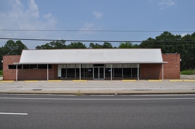
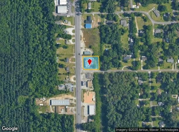
Property Record
2910 Main St, Millbrook, AL 36054
NEARBY LISTINGS FOR SALE OR LEASE
-
-
View all Millbrook listings for lease on LoopNet.com
Property Detail
2910 Main St
26-02-10-2-001-032000-0
BEG AT INT OF W ROW MAIN ST (SH 143) AND N ROW CHARMWOOD DR IN NW1/4 NW1/4 SEC 10 T17N R17E; NW 22.61' ALONG HWY ROW FLARE; N
Storesoffices
Elmore
X
Alabama
01051C0426F
0.61 AC
2025
Prattville/Millbrook
2024
Montgomery
031300
Montgomery, AL
9,399 SF
DEMOGRAPHICS near 2910 Main St
1 Mile
3 Mile
5 Mile
2024 Total Population
2,099
10,607
39,752
2029 Population
2,139
10,848
40,839
Pop Growth 2024-2029
+ 1.91%
+ 2.27%
+ 2.73%
Average Age
40
38
38
2024 Total Households
829
4,264
15,646
HH Growth 2024-2029
+ 1.81%
+ 2.18%
+ 2.61%
Median Household Inc
$45,476
$47,161
$57,175
Avg Household Size
2.50
2.50
2.50
2024 Avg HH Vehicles
2.00
2.00
2.00
Median Home Value
$133,437
$157,715
$181,454
Median Year Built
1975
1991
1996
Nearby Places
Map Layers
Map Styles
 Street
 Aerial
- Restaurants
- Banks
- Shops
- Fitness
- Groceries
PUBLIC TRANSPORTATION
AIRPORT
Montgomery Regional (Dannelly Field)
DRIVE
WALK
Distance
Montgomery Regional (Dannelly Field)
23 min
16.0 mi
Freight Ports
Port of Mobile
DRIVE
WALK
Distance
Port of Mobile
193 min
175.0 mi
SALE & LEASE HISTORY
LISTING DATE
SALE/LEASE

Sep 23, 2016
For Sale
Oct 18, 2017
For Lease
Nearby Properties
Address
Land Use
TOTAL SIZE
Lot Size
Zoning
Address
Land Use
TOTAL SIZE
Lot Size
Zoning
136,080 SF
26.42 AC
Address
Land Use
TOTAL SIZE
Lot Size
Zoning
98,613 SF
10.45 AC
Address
Land Use
TOTAL SIZE
Lot Size
Zoning
9,176 SF
11.39 AC
Address
Land Use
TOTAL SIZE
Lot Size
Zoning
217,253 SF
29.84 AC
Address
Land Use
TOTAL SIZE
Lot Size
Zoning
128,384 SF
9.07 AC
Address
Land Use
TOTAL SIZE
Lot Size
Zoning
136,297 SF
16.32 AC
Address
Land Use
TOTAL SIZE
Lot Size
Zoning
90,958 SF
8.15 AC
Address
Land Use
TOTAL SIZE
Lot Size
Zoning
75,571 SF
17.63 AC
Address
Land Use
TOTAL SIZE
Lot Size
Zoning
90,997 SF
24.80 AC
Address
Land Use
TOTAL SIZE
Lot Size
Zoning
4,050 SF
40.59 AC
Address
Land Use
TOTAL SIZE
Lot Size
Zoning
44,892 SF
2.18 AC
Address
Land Use
TOTAL SIZE
Lot Size
Zoning
104,965 SF
10.13 AC
Address
Land Use
TOTAL SIZE
Lot Size
Zoning
57,782 SF
3.30 AC
Address
Land Use
TOTAL SIZE
Lot Size
Zoning
18,384 SF
2.40 AC
Address
Land Use
TOTAL SIZE
Lot Size
Zoning
60,838 SF
Address
Land Use
TOTAL SIZE
Lot Size
Zoning
39,155 SF
3.61 AC
Address
Land Use
TOTAL SIZE
Lot Size
Zoning
60,164 SF
31.84 AC
Address
Land Use
TOTAL SIZE
Lot Size
Zoning
44,834 SF
2 AC
Address
Land Use
TOTAL SIZE
Lot Size
Zoning
45,584 SF
2.35 AC
Address
Land Use
TOTAL SIZE
Lot Size
Zoning
97,498 SF
9.08 AC
Address
Land Use
TOTAL SIZE
Lot Size
Zoning
64,502 SF
5.01 AC
Address
Land Use
TOTAL SIZE
Lot Size
Zoning
105,581 SF
2.80 AC
Address
Land Use
TOTAL SIZE
Lot Size
Zoning
43,139 SF
7.96 AC
Address
Land Use
TOTAL SIZE
Lot Size
Zoning
38,886 SF
1.68 AC
Address
Land Use
TOTAL SIZE
Lot Size
Zoning
33,028 SF
4.49 AC
Address
Land Use
TOTAL SIZE
Lot Size
Zoning
16,664 SF
3.16 AC
Address
Land Use
TOTAL SIZE
Lot Size
Zoning
46,656 SF
2.50 AC
Address
Land Use
TOTAL SIZE
Lot Size
Zoning
21,091 SF
2.51 AC
Address
Land Use
TOTAL SIZE
Lot Size
Zoning
30,705 SF
1.51 AC
Address
Land Use
TOTAL SIZE
Lot Size
Zoning
36,777 SF
1.34 AC
The World's #1 Commercial Real Estate Marketplace
Connect with us
© 2025 CoStar Group
The information above has been obtained from sources believed reliable. While we do not doubt its accuracy we have not verified it and make no guarantee, warranty or representation about it. It is your responsibility to independently confirm its accuracy and completeness. Any projections, opinions, assumptions, or estimates used are for example only and do not represent the current or future performance of the property. The value of this transaction to you depends on tax and other factors which should be evaluated by your tax, financial, and legal advisors. You and your advisors should conduct a careful, independent investigation of the property to determine to your satisfaction the suitability of the property for your needs.