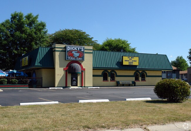
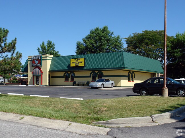
Property Record
2910 Maplecrest Rd, Fort Wayne, IN 46815

Property Detail
2910 Maplecrest Rd
02-08-34-102-013.000-072
N 160 OF S 1167.1 OF E 200 OF W 249.43FT N OF STATE ST NW1/4 SEC 34 EX PT TO RD
Restaurantbuilding
Allen
C and X Area of minimal flood hazard, usually depicted on FIRMs as above the 500-year flood level.
Indiana
2024
7.02 AC
2025
North Fort Wayne
010809
Fort Wayne
3,910 SF
Fort Wayne, IN
NEARBY LISTINGS FOR SALE OR LEASE
DEMOGRAPHICS near 2910 Maplecrest Rd
1 mile
3 mile
5 mile
2025 Total Population
11,610
62,742
153,424
2030 Population
11,735
64,015
157,849
Pop Growth 2025-2030
+ 1.08%
+ 2.03%
+ 2.88%
Average Age
39
39
38
2025 Total Households
4,485
26,133
62,393
HH Growth 2025-2030
+ 1.18%
+ 2.14%
+ 3.02%
Median Household Inc
$67,033
$63,925
$57,922
Avg Household Size
2.50
2.30
2.30
2025 Avg HH Vehicles
2.00
2.00
2.00
Median Home Value
$218,101
$198,306
$185,938
Median Year Built
1973
1974
1971
Nearby Places
Map Layers
Map Styles
 Street
 Aerial
Transit
 Traffic
 Biking
Places
Listings with unknown addresses are not visible on the map
- Restaurants
- Banks
- Shops
- Fitness
- Groceries
PUBLIC TRANSPORTATION
AIRPORT
Fort Wayne International
Drive
Walk
Distance
Fort Wayne International
30 min
16.1 mi
Nearby Properties
Address
Land Use
TOTAL SIZE
Lot Size
Zoning
Address
Land Use
TOTAL SIZE
Lot Size
Zoning
921,633 SF
18.04 AC
Address
Land Use
TOTAL SIZE
Lot Size
Zoning
702,400 SF
37.91 AC
Address
Land Use
TOTAL SIZE
Lot Size
Zoning
129,080 SF
15.77 AC
Address
Land Use
TOTAL SIZE
Lot Size
Zoning
298,087 SF
24.71 AC
Address
Land Use
TOTAL SIZE
Lot Size
Zoning
23,326 SF
152.70 AC
Address
Land Use
TOTAL SIZE
Lot Size
Zoning
75,690 SF
268.40 AC
Address
Land Use
TOTAL SIZE
Lot Size
Zoning
32,189 SF
9.65 AC
Address
Land Use
TOTAL SIZE
Lot Size
Zoning
125,249 SF
362.70 AC
Address
Land Use
TOTAL SIZE
Lot Size
Zoning
215,768 SF
235.57 AC
Address
Land Use
TOTAL SIZE
Lot Size
Zoning
58,913 SF
226.43 AC
Address
Land Use
TOTAL SIZE
Lot Size
Zoning
25,272 SF
25.84 AC
Address
Land Use
TOTAL SIZE
Lot Size
Zoning
62,666 SF
20.58 AC
Address
Land Use
TOTAL SIZE
Lot Size
Zoning
255,864 SF
9.21 AC
Address
Land Use
TOTAL SIZE
Lot Size
Zoning
137,278 SF
21.46 AC
Address
Land Use
TOTAL SIZE
Lot Size
Zoning
180,238 SF
22.50 AC
Address
Land Use
TOTAL SIZE
Lot Size
Zoning
232,515 SF
306.20 AC
Address
Land Use
TOTAL SIZE
Lot Size
Zoning
19,872 SF
14.05 AC
Address
Land Use
TOTAL SIZE
Lot Size
Zoning
250,021 SF
2.25 AC
Address
Land Use
TOTAL SIZE
Lot Size
Zoning
50,072 SF
8.27 AC
Address
Land Use
TOTAL SIZE
Lot Size
Zoning
94,025 SF
89.40 AC
Address
Land Use
TOTAL SIZE
Lot Size
Zoning
126,957 SF
212.70 AC
Address
Land Use
TOTAL SIZE
Lot Size
Zoning
154,746 SF
87.54 AC
Address
Land Use
TOTAL SIZE
Lot Size
Zoning
160,355 SF
71.69 AC
Address
Land Use
TOTAL SIZE
Lot Size
Zoning
237,829 SF
498.63 AC
Address
Land Use
TOTAL SIZE
Lot Size
Zoning
72,240 SF
94.11 AC
Address
Land Use
TOTAL SIZE
Lot Size
Zoning
142,983 SF
10.55 AC
Address
Land Use
TOTAL SIZE
Lot Size
Zoning
70,312 SF
25.38 AC
Address
Land Use
TOTAL SIZE
Lot Size
Zoning
88,894 SF
165.50 AC
Address
Land Use
TOTAL SIZE
Lot Size
Zoning
121,567 SF
73.70 AC
Address
Land Use
TOTAL SIZE
Lot Size
Zoning
85,528 SF
83.30 AC
The World's #1 Commercial Real Estate Marketplace
Connect with us
© 2026 CoStar Group
The information above has been obtained from sources believed reliable. While we do not doubt its accuracy we have not verified it and make no guarantee, warranty or representation about it. It is your responsibility to independently confirm its accuracy and completeness. Any projections, opinions, assumptions, or estimates used are for example only and do not represent the current or future performance of the property. The value of this transaction to you depends on tax and other factors which should be evaluated by your tax, financial, and legal advisors. You and your advisors should conduct a careful, independent investigation of the property to determine to your satisfaction the suitability of the property for your needs.