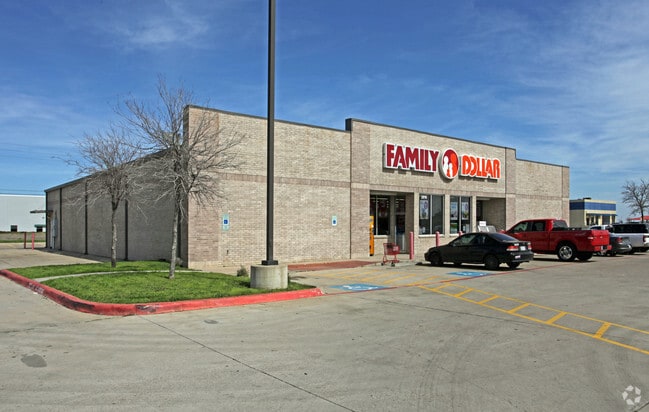
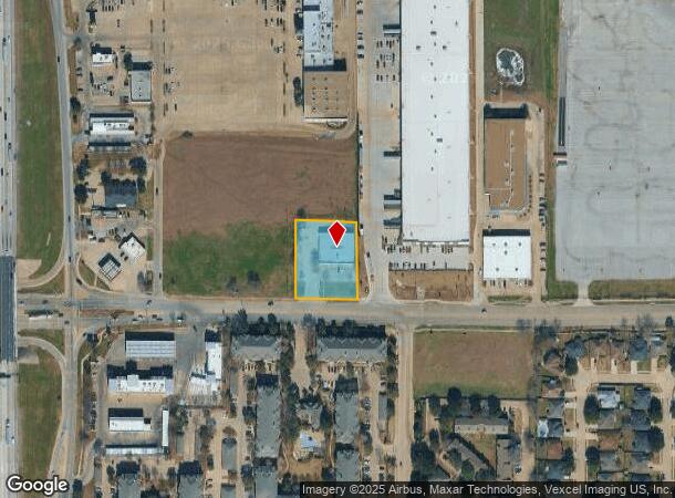
Property Record
2910 Mayfield Rd, Grand Prairie, TX 75052
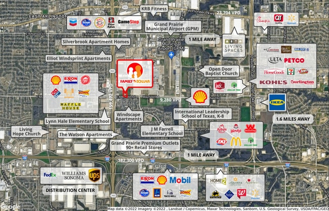

NEARBY LISTINGS FOR SALE OR LEASE
Property Detail
2910 Mayfield Rd
Dallas-Fort Worth-Arlington, TX
Fd One Addition
41183347
FD ONE ADDITION - GP BLOCK 1 LOT 1
Commercialnec
Tarrant
X
Texas
48439C0360L
1
2024
0.97 AC
2025
North Grand Prairie
111536
Dallas/Ft Worth
9,180 SF
DEMOGRAPHICS near 2910 Mayfield Rd
1 Mile
3 Mile
5 Mile
2024 Total Population
15,288
138,728
329,558
2029 Population
16,221
144,710
341,422
Pop Growth 2024-2029
+ 6.10%
+ 4.31%
+ 3.60%
Average Age
33
34
35
2024 Total Households
5,474
45,304
108,949
HH Growth 2024-2029
+ 5.94%
+ 4.36%
+ 3.72%
Median Household Inc
$52,360
$56,816
$59,280
Avg Household Size
2.70
3.00
2.90
2024 Avg HH Vehicles
2.00
2.00
2.00
Median Home Value
$193,930
$208,891
$215,950
Median Year Built
1988
1983
1984
Nearby Places
Map Layers
Map Styles
 Street
 Aerial
- Restaurants
- Banks
- Shops
- Fitness
- Groceries
PUBLIC TRANSPORTATION
AIRPORT
Dallas-Fort Worth International
DRIVE
WALK
Distance
Dallas-Fort Worth International
24 min
16.4 mi
Dallas Love Field
DRIVE
WALK
Distance
Dallas Love Field
36 min
24.8 mi
SALE & LEASE HISTORY
LISTING DATE
SALE/LEASE

May 16, 2022
For Sale
Apr 06, 2022
For Sale
Nearby Properties
Address
Land Use
TOTAL SIZE
Lot Size
Zoning
Address
Land Use
TOTAL SIZE
Lot Size
Zoning
804,384 SF
48.38 AC
Address
Land Use
TOTAL SIZE
Lot Size
Zoning
1,577,320 SF
122.55 AC
Z123
Address
Land Use
TOTAL SIZE
Lot Size
Zoning
860,445 SF
50.39 AC
Z123
Address
Land Use
TOTAL SIZE
Lot Size
Zoning
529,992 SF
35.21 AC
Address
Land Use
TOTAL SIZE
Lot Size
Zoning
456,473 SF
32.79 AC
Address
Land Use
TOTAL SIZE
Lot Size
Zoning
1,114,563 SF
89.72 AC
Address
Land Use
TOTAL SIZE
Lot Size
Zoning
485,300 SF
16.51 AC
Z312
Address
Land Use
TOTAL SIZE
Lot Size
Zoning
428,147 SF
14.45 AC
Z313
Address
Land Use
TOTAL SIZE
Lot Size
Zoning
368,004 SF
13.89 AC
Address
Land Use
TOTAL SIZE
Lot Size
Zoning
301,120 SF
14.23 AC
Z313
Address
Land Use
TOTAL SIZE
Lot Size
Zoning
266,460 SF
12 AC
Z313
Address
Land Use
TOTAL SIZE
Lot Size
Zoning
753,721 SF
42.65 AC
Address
Land Use
TOTAL SIZE
Lot Size
Zoning
478,110 SF
11.74 AC
Z313
Address
Land Use
TOTAL SIZE
Lot Size
Zoning
247,880 SF
20.93 AC
Z236
Address
Land Use
TOTAL SIZE
Lot Size
Zoning
206,650 SF
18.92 AC
Address
Land Use
TOTAL SIZE
Lot Size
Zoning
402,935 SF
20.72 AC
Address
Land Use
TOTAL SIZE
Lot Size
Zoning
375,213 SF
17.77 AC
Address
Land Use
TOTAL SIZE
Lot Size
Zoning
298,234 SF
23.39 AC
Address
Land Use
TOTAL SIZE
Lot Size
Zoning
280,000 SF
10.85 AC
Address
Land Use
TOTAL SIZE
Lot Size
Zoning
1,054,767 SF
37.45 AC
Z123
Address
Land Use
TOTAL SIZE
Lot Size
Zoning
821,502 SF
45.37 AC
Address
Land Use
TOTAL SIZE
Lot Size
Zoning
352,999 SF
60.81 AC
Address
Land Use
TOTAL SIZE
Lot Size
Zoning
603,000 SF
32.80 AC
Z123
Address
Land Use
TOTAL SIZE
Lot Size
Zoning
315,359 SF
15 AC
Address
Land Use
TOTAL SIZE
Lot Size
Zoning
229,000 SF
8.01 AC
Address
Land Use
TOTAL SIZE
Lot Size
Zoning
387,500 SF
13.54 AC
Z313
Address
Land Use
TOTAL SIZE
Lot Size
Zoning
252,800 SF
21.59 AC
Z236
Address
Land Use
TOTAL SIZE
Lot Size
Zoning
193,680 SF
8.25 AC
Address
Land Use
TOTAL SIZE
Lot Size
Zoning
272,000 SF
8.07 AC
Z313
Address
Land Use
TOTAL SIZE
Lot Size
Zoning
816,040 SF
41.89 AC
The World's #1 Commercial Real Estate Marketplace
Connect with us
© 2025 CoStar Group
The information above has been obtained from sources believed reliable. While we do not doubt its accuracy we have not verified it and make no guarantee, warranty or representation about it. It is your responsibility to independently confirm its accuracy and completeness. Any projections, opinions, assumptions, or estimates used are for example only and do not represent the current or future performance of the property. The value of this transaction to you depends on tax and other factors which should be evaluated by your tax, financial, and legal advisors. You and your advisors should conduct a careful, independent investigation of the property to determine to your satisfaction the suitability of the property for your needs.