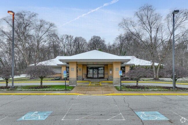
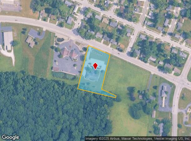
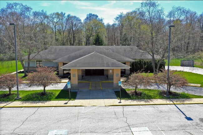
Property Record
2910 Monroe St, La Porte, IN 46350
NEARBY LISTINGS FOR SALE OR LEASE
Property Detail
2910 Monroe St
46-11-06-178-008.000-058
57-11-06-178-008 IN E 1/2 NW 1/4 S6 T36 R2 2.13 AC PER DEED 07R-19471
Medicalbuilding
La Porte
X
Indiana
18091C0280D
2.13 AC
2024
South Bend/Elkhart
2025
Other Market Areas
042200
Michigan City-La Porte, IN
5,932 SF
DEMOGRAPHICS near 2910 Monroe St
1 Mile
3 Mile
5 Mile
2024 Total Population
3,074
23,992
31,488
2029 Population
3,025
23,637
31,054
Pop Growth 2024-2029
(1.59%)
(1.48%)
(1.38%)
Average Age
41
40
40
2024 Total Households
1,273
9,580
12,457
HH Growth 2024-2029
(1.81%)
(1.71%)
(1.57%)
Median Household Inc
$61,403
$53,321
$60,730
Avg Household Size
2.40
2.40
2.40
2024 Avg HH Vehicles
2.00
2.00
2.00
Median Home Value
$144,607
$144,304
$167,240
Median Year Built
1959
1955
1960
Nearby Places
Map Layers
Map Styles
 Street
 Aerial
- Restaurants
- Banks
- Shops
- Fitness
- Groceries
PUBLIC TRANSPORTATION
AIRPORT
South Bend International
DRIVE
WALK
Distance
South Bend International
46 min
26.0 mi
Freight Ports
Port Milwaukee
DRIVE
WALK
Distance
Port Milwaukee
196 min
156.4 mi
SALE & LEASE HISTORY
LISTING DATE
SALE/LEASE

Oct 22, 2024
For Sale
May 11, 2023
For Sale
May 04, 2022
For Lease
Feb 14, 2023
For Lease
Dec 28, 2023
For Sale
Apr 21, 2025
For Sale
Apr 12, 2024
For Lease
Nearby Properties
Address
Land Use
TOTAL SIZE
Lot Size
Zoning
Address
Land Use
TOTAL SIZE
Lot Size
Zoning
38,110 SF
5.25 AC
Address
Land Use
TOTAL SIZE
Lot Size
Zoning
93,819 SF
3.72 AC
Address
Land Use
TOTAL SIZE
Lot Size
Zoning
33,252 SF
49.97 AC
Address
Land Use
TOTAL SIZE
Lot Size
Zoning
489,580 SF
45.42 AC
Address
Land Use
TOTAL SIZE
Lot Size
Zoning
46,959 SF
6 AC
Address
Land Use
TOTAL SIZE
Lot Size
Zoning
150,000 SF
22.86 AC
Address
Land Use
TOTAL SIZE
Lot Size
Zoning
8,124 SF
10.51 AC
Address
Land Use
TOTAL SIZE
Lot Size
Zoning
106,778 SF
15.78 AC
Address
Land Use
TOTAL SIZE
Lot Size
Zoning
47,659 SF
22.32 AC
Address
Land Use
TOTAL SIZE
Lot Size
Zoning
53,665 SF
8.02 AC
Address
Land Use
TOTAL SIZE
Lot Size
Zoning
840 SF
18.96 AC
Address
Land Use
TOTAL SIZE
Lot Size
Zoning
47,168 SF
4.44 AC
Address
Land Use
TOTAL SIZE
Lot Size
Zoning
63,583 SF
16.87 AC
Address
Land Use
TOTAL SIZE
Lot Size
Zoning
50,832 SF
14.26 AC
Address
Land Use
TOTAL SIZE
Lot Size
Zoning
21,962 SF
5.14 AC
Address
Land Use
TOTAL SIZE
Lot Size
Zoning
32,470 SF
5.71 AC
Address
Land Use
TOTAL SIZE
Lot Size
Zoning
193,743 SF
17.50 AC
Address
Land Use
TOTAL SIZE
Lot Size
Zoning
33,562 SF
11.99 AC
Address
Land Use
TOTAL SIZE
Lot Size
Zoning
25,686 SF
2.68 AC
Address
Land Use
TOTAL SIZE
Lot Size
Zoning
51,910 SF
4.89 AC
Address
Land Use
TOTAL SIZE
Lot Size
Zoning
1,109 SF
13.19 AC
Address
Land Use
TOTAL SIZE
Lot Size
Zoning
21,218 SF
10 AC
Address
Land Use
TOTAL SIZE
Lot Size
Zoning
36,000 SF
52.13 AC
Address
Land Use
TOTAL SIZE
Lot Size
Zoning
7,164 SF
6.87 AC
Address
Land Use
TOTAL SIZE
Lot Size
Zoning
60,213 SF
11.46 AC
Address
Land Use
TOTAL SIZE
Lot Size
Zoning
46,345 SF
37.29 AC
Address
Land Use
TOTAL SIZE
Lot Size
Zoning
6,970 SF
1.59 AC
Address
Land Use
TOTAL SIZE
Lot Size
Zoning
26,586 SF
6.15 AC
Address
Land Use
TOTAL SIZE
Lot Size
Zoning
19,230 SF
2.32 AC
Address
Land Use
TOTAL SIZE
Lot Size
Zoning
23,470 SF
4.54 AC
The World's #1 Commercial Real Estate Marketplace
Connect with us
© 2026 CoStar Group
The information above has been obtained from sources believed reliable. While we do not doubt its accuracy we have not verified it and make no guarantee, warranty or representation about it. It is your responsibility to independently confirm its accuracy and completeness. Any projections, opinions, assumptions, or estimates used are for example only and do not represent the current or future performance of the property. The value of this transaction to you depends on tax and other factors which should be evaluated by your tax, financial, and legal advisors. You and your advisors should conduct a careful, independent investigation of the property to determine to your satisfaction the suitability of the property for your needs.