Property Record
2911 Cedar Ave, Las Vegas, NV 89101
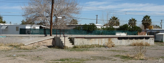
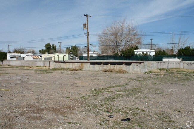

Property Detail
2911 Cedar Ave
Las Vegas-Henderson-North Las Vegas, NV
PT GOV LOT 1
162-01-502-009
CLARK
Vacantlandnec
Nevada
R3
1
B and X Area of moderate flood hazard, usually the area between the limits of the 100-year and 500-year floods.
0.08 AC
2026
Central Las Vegas
2026
Las Vegas
000522
NEARBY LISTINGS FOR SALE OR LEASE
DEMOGRAPHICS near 2911 Cedar Ave
1 mile
3 mile
5 mile
2025 Total Population
24,989
240,357
549,861
2030 Population
26,350
251,402
574,751
Pop Growth 2025-2030
+ 5.45%
+ 4.60%
+ 4.53%
Average Age
39
38
38
2025 Total Households
9,707
86,368
197,777
HH Growth 2025-2030
+ 5.61%
+ 4.80%
+ 4.67%
Median Household Inc
$38,569
$47,718
$52,315
Avg Household Size
2.50
2.70
2.70
2025 Avg HH Vehicles
1.00
1.00
2.00
Median Home Value
$160,040
$301,872
$331,754
Median Year Built
1977
1980
1982
Nearby Places
Map Layers
Map Styles
 Street
 Aerial
Layers
 Traffic
 Biking
Places
Listings with unknown addresses are not visible on the map
- Restaurants
- Banks
- Shops
- Fitness
- Groceries
PUBLIC TRANSPORTATION
AIRPORT
Harry Reid International
Drive
Walk
Distance
Harry Reid International
16 min
8.2 mi
Boulder City Municipal
Drive
Walk
Distance
Boulder City Municipal
31 min
23.5 mi
Nearby Properties
Address
Land Use
TOTAL SIZE
Lot Size
Zoning
Address
Land Use
TOTAL SIZE
Lot Size
Zoning
79,707 SF
2.76 AC
Address
Land Use
TOTAL SIZE
Lot Size
Zoning
39,972 SF
3.04 AC
CV
Address
Land Use
TOTAL SIZE
Lot Size
Zoning
162,214 SF
4.32 AC
Address
Land Use
TOTAL SIZE
Lot Size
Zoning
162,501 SF
5.77 AC
C2
Address
Land Use
TOTAL SIZE
Lot Size
Zoning
18,125 SF
2.14 AC
Address
Land Use
TOTAL SIZE
Lot Size
Zoning
1,617,320 SF
7.21 AC
PD
Address
Land Use
TOTAL SIZE
Lot Size
Zoning
2.79 AC
CV
Address
Land Use
TOTAL SIZE
Lot Size
Zoning
281,120 SF
21.38 AC
Address
Land Use
TOTAL SIZE
Lot Size
Zoning
5.96 AC
C2
Address
Land Use
TOTAL SIZE
Lot Size
Zoning
44,418 SF
5.08 AC
PD
Address
Land Use
TOTAL SIZE
Lot Size
Zoning
345,133 SF
27.01 AC
H1
Address
Land Use
TOTAL SIZE
Lot Size
Zoning
123,990 SF
2.18 AC
C2
Address
Land Use
TOTAL SIZE
Lot Size
Zoning
38.80 AC
CV
Address
Land Use
TOTAL SIZE
Lot Size
Zoning
23,901 SF
5.25 AC
PD
Address
Land Use
TOTAL SIZE
Lot Size
Zoning
324 SF
8.74 AC
R1
Address
Land Use
TOTAL SIZE
Lot Size
Zoning
53,435 SF
2.98 AC
C2
Address
Land Use
TOTAL SIZE
Lot Size
Zoning
709,943 SF
43.10 AC
C2
Address
Land Use
TOTAL SIZE
Lot Size
Zoning
16,004 SF
4.19 AC
Address
Land Use
TOTAL SIZE
Lot Size
Zoning
6,396 SF
15.06 AC
Address
Land Use
TOTAL SIZE
Lot Size
Zoning
198,388 SF
1.88 AC
C2
Address
Land Use
TOTAL SIZE
Lot Size
Zoning
520,114 SF
2.03 AC
Address
Land Use
TOTAL SIZE
Lot Size
Zoning
55,639 SF
6.13 AC
CV
Address
Land Use
TOTAL SIZE
Lot Size
Zoning
103,573 SF
2.75 AC
Address
Land Use
TOTAL SIZE
Lot Size
Zoning
2.84 AC
Address
Land Use
TOTAL SIZE
Lot Size
Zoning
61,010 SF
1.88 AC
M
Address
Land Use
TOTAL SIZE
Lot Size
Zoning
274,676 SF
1.01 AC
Address
Land Use
TOTAL SIZE
Lot Size
Zoning
67,649 SF
13.42 AC
CV
Address
Land Use
TOTAL SIZE
Lot Size
Zoning
22.77 AC
CV
The World's #1 Commercial Real Estate Marketplace
Connect with us
© 2026 CoStar Group
The information above has been obtained from sources believed reliable. While we do not doubt its accuracy we have not verified it and make no guarantee, warranty or representation about it. It is your responsibility to independently confirm its accuracy and completeness. Any projections, opinions, assumptions, or estimates used are for example only and do not represent the current or future performance of the property. The value of this transaction to you depends on tax and other factors which should be evaluated by your tax, financial, and legal advisors. You and your advisors should conduct a careful, independent investigation of the property to determine to your satisfaction the suitability of the property for your needs.