Property Record
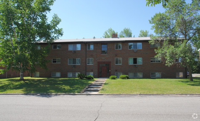
2911 Harwick Dr, Lansing, MI 48917


Property Detail
2911 Harwick Dr
21-01-07-407-006
LOTS 103 & 104 WESTFIELD HILLS NO 6
Multifamilydwelling
Ingham
C1 RESI
Michigan
B and X Area of moderate flood hazard, usually the area between the limits of the 100-year and 500-year floods.
103-104
2024
0.41 AC
2025
Edgemont Park
003400
West Michigan
11,520 SF
Lansing-East Lansing, MI
NEARBY LISTINGS FOR SALE OR LEASE
DEMOGRAPHICS near 2911 Harwick Dr
1 mile
3 mile
5 mile
2025 Total Population
8,410
66,221
152,329
2030 Population
8,467
67,222
154,927
Pop Growth 2025-2030
+ 0.68%
+ 1.51%
+ 1.71%
Average Age
40
40
38
2025 Total Households
3,756
29,933
66,310
HH Growth 2025-2030
+ 0.64%
+ 1.63%
+ 1.79%
Median Household Inc
$60,360
$57,862
$58,616
Avg Household Size
2.20
2.10
2.20
2025 Avg HH Vehicles
2.00
1.00
2.00
Median Home Value
$151,228
$161,163
$162,610
Median Year Built
1956
1959
1964
Nearby Places
Map Layers
Map Styles
 Street
 Aerial
Layers
 Traffic
 Biking
Places
Listings with unknown addresses are not visible on the map
- Restaurants
- Banks
- Shops
- Fitness
- Groceries
PUBLIC TRANSPORTATION
COMMUTER RAIL
Drive
Walk
Distance
15 min
7.1 mi
AIRPORT
Capital Region International
Drive
Walk
Distance
Capital Region International
9 min
3.7 mi
Nearby Properties
Address
Land Use
TOTAL SIZE
Lot Size
Zoning
Address
Land Use
TOTAL SIZE
Lot Size
Zoning
111,180 SF
3.63 AC
G-1 BUS
Address
Land Use
TOTAL SIZE
Lot Size
Zoning
177,300 SF
8.72 AC
Address
Land Use
TOTAL SIZE
Lot Size
Zoning
69,851 SF
134.23 AC
I HVY
Address
Land Use
TOTAL SIZE
Lot Size
Zoning
166,083 SF
39.98 AC
NONE
Address
Land Use
TOTAL SIZE
Lot Size
Zoning
2,137 SF
12.72 AC
H LT IN
Address
Land Use
TOTAL SIZE
Lot Size
Zoning
389,485 SF
30.04 AC
NONE
Address
Land Use
TOTAL SIZE
Lot Size
Zoning
185,190 SF
0.41 AC
G-1 BUS
Address
Land Use
TOTAL SIZE
Lot Size
Zoning
150,589 SF
3.06 AC
D-1 PRO
Address
Land Use
TOTAL SIZE
Lot Size
Zoning
332,832 SF
2.48 AC
G-1 BUS
Address
Land Use
TOTAL SIZE
Lot Size
Zoning
436,698 SF
48.16 AC
NONE
Address
Land Use
TOTAL SIZE
Lot Size
Zoning
2,276,790 SF
96.93 AC
NONE
Address
Land Use
TOTAL SIZE
Lot Size
Zoning
51,248 SF
4.85 AC
I HVY
Address
Land Use
TOTAL SIZE
Lot Size
Zoning
169,704 SF
0.67 AC
G-1 BUS
Address
Land Use
TOTAL SIZE
Lot Size
Zoning
165,684 SF
1.20 AC
G-1 BUS
Address
Land Use
TOTAL SIZE
Lot Size
Zoning
159,455 SF
0.42 AC
Address
Land Use
TOTAL SIZE
Lot Size
Zoning
157,548 SF
0.72 AC
Address
Land Use
TOTAL SIZE
Lot Size
Zoning
235,893 SF
18.69 AC
NONE
Address
Land Use
TOTAL SIZE
Lot Size
Zoning
114,681 SF
1.08 AC
G-1 BUS
Address
Land Use
TOTAL SIZE
Lot Size
Zoning
67,365 SF
4.19 AC
H LT IN
Address
Land Use
TOTAL SIZE
Lot Size
Zoning
73,485 SF
7.86 AC
LI
Address
Land Use
TOTAL SIZE
Lot Size
Zoning
Address
Land Use
TOTAL SIZE
Lot Size
Zoning
189,157 SF
15.55 AC
NONE
Address
Land Use
TOTAL SIZE
Lot Size
Zoning
121,536 SF
2 AC
Address
Land Use
TOTAL SIZE
Lot Size
Zoning
76,606 SF
1.75 AC
Address
Land Use
TOTAL SIZE
Lot Size
Zoning
140,722 SF
1.40 AC
Address
Land Use
TOTAL SIZE
Lot Size
Zoning
14,505 SF
90 AC
Address
Land Use
TOTAL SIZE
Lot Size
Zoning
78,000 SF
0.18 AC
G-1 BUS
Address
Land Use
TOTAL SIZE
Lot Size
Zoning
106,344 SF
10.69 AC
NONE
Address
Land Use
TOTAL SIZE
Lot Size
Zoning
179,316 SF
16.68 AC
NONE
Address
Land Use
TOTAL SIZE
Lot Size
Zoning
96,593 SF
11.65 AC
NONE
The World's #1 Commercial Real Estate Marketplace
Connect with us
© 2026 CoStar Group
The information above has been obtained from sources believed reliable. While we do not doubt its accuracy we have not verified it and make no guarantee, warranty or representation about it. It is your responsibility to independently confirm its accuracy and completeness. Any projections, opinions, assumptions, or estimates used are for example only and do not represent the current or future performance of the property. The value of this transaction to you depends on tax and other factors which should be evaluated by your tax, financial, and legal advisors. You and your advisors should conduct a careful, independent investigation of the property to determine to your satisfaction the suitability of the property for your needs.