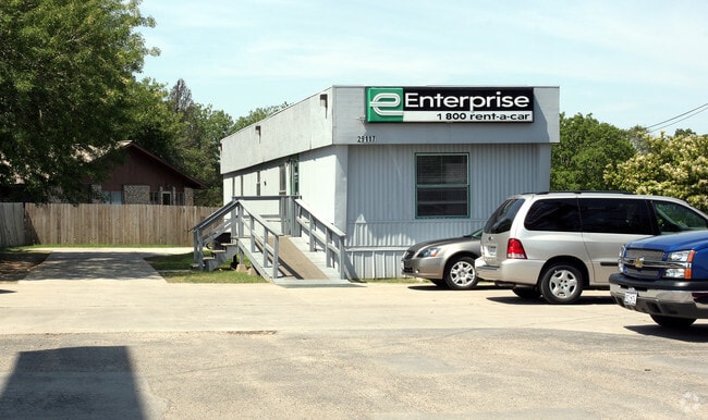
Property Record
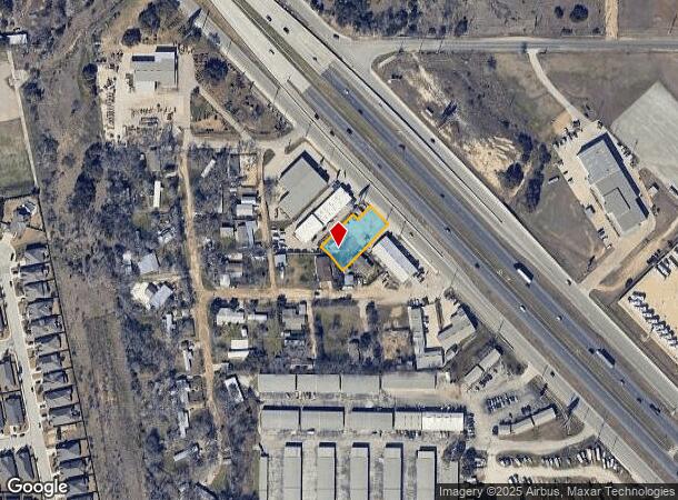
29117 Interstate 10 W, Boerne, TX 78006
NEARBY LISTINGS FOR SALE OR LEASE
Property Detail
29117 Interstate 10 W
San Antonio-New Braunfels, TX
Conv A/S Code
04707-314-0093
CB 4707C BLK 14 LOT SW 137.88 FT OF 9 2008-REMAINS PER SPLIT PER DEED 12898/353 & 12718/190
Radioortvstationcommunications
Bexar
X
Texas
48259C0525F
93
2024
0.42 AC
2025
Far Northwest
970404
San Antonio
600 SF
DEMOGRAPHICS near 29117 Interstate 10 W
1 mile
3 mile
5 mile
2024 Total Population
3,067
25,851
56,972
2029 Population
3,300
29,456
65,454
Pop Growth 2024-2029
+ 7.60%
+ 13.95%
+ 14.89%
Average Age
40
39
39
2024 Total Households
1,079
9,023
19,696
HH Growth 2024-2029
+ 7.88%
+ 14.41%
+ 15.35%
Median Household Inc
$117,499
$127,511
$122,370
Avg Household Size
2.80
2.80
2.90
2024 Avg HH Vehicles
2.00
2.00
2.00
Median Home Value
$455,663
$443,845
$426,603
Median Year Built
2006
2010
2009
Nearby Places
Map Layers
Map Styles
 Street
 Aerial
Transit
 Traffic
 Biking
Places
Listings with unknown addresses are not visible on the map
- Restaurants
- Banks
- Shops
- Fitness
- Groceries
PUBLIC TRANSPORTATION
AIRPORT
San Antonio International
Drive
Walk
Distance
San Antonio International
28 min
23.1 mi
Freight Ports
Calhoun Port
Drive
Walk
Distance
Calhoun Port
207 min
174.7 mi
Nearby Properties
Address
Land Use
TOTAL SIZE
Lot Size
Zoning
Address
Land Use
TOTAL SIZE
Lot Size
Zoning
252,468 SF
56.42 AC
Address
Land Use
TOTAL SIZE
Lot Size
Zoning
260,536 SF
10.71 AC
Address
Land Use
TOTAL SIZE
Lot Size
Zoning
282,991 SF
26.41 AC
Address
Land Use
TOTAL SIZE
Lot Size
Zoning
265,093 SF
12.55 AC
Address
Land Use
TOTAL SIZE
Lot Size
Zoning
255,907 SF
19.93 AC
Address
Land Use
TOTAL SIZE
Lot Size
Zoning
215,736 SF
10.06 AC
Address
Land Use
TOTAL SIZE
Lot Size
Zoning
126,885 SF
16 AC
Address
Land Use
TOTAL SIZE
Lot Size
Zoning
49,164 SF
11.98 AC
Address
Land Use
TOTAL SIZE
Lot Size
Zoning
46,562 SF
3.02 AC
Address
Land Use
TOTAL SIZE
Lot Size
Zoning
247,144 SF
17.49 AC
Address
Land Use
TOTAL SIZE
Lot Size
Zoning
145,171 SF
13.65 AC
Address
Land Use
TOTAL SIZE
Lot Size
Zoning
91,013 SF
6.45 AC
Address
Land Use
TOTAL SIZE
Lot Size
Zoning
43,422 SF
6.38 AC
Address
Land Use
TOTAL SIZE
Lot Size
Zoning
297,618 SF
13.20 AC
Address
Land Use
TOTAL SIZE
Lot Size
Zoning
36,632 SF
142.92 AC
Address
Land Use
TOTAL SIZE
Lot Size
Zoning
1,183 SF
610.48 AC
Address
Land Use
TOTAL SIZE
Lot Size
Zoning
11,844 SF
160.22 AC
Address
Land Use
TOTAL SIZE
Lot Size
Zoning
42,101 SF
6.03 AC
Address
Land Use
TOTAL SIZE
Lot Size
Zoning
60,750 SF
15.53 AC
Address
Land Use
TOTAL SIZE
Lot Size
Zoning
175.13 AC
Address
Land Use
TOTAL SIZE
Lot Size
Zoning
103,963 SF
1.98 AC
Address
Land Use
TOTAL SIZE
Lot Size
Zoning
48,139 SF
10.38 AC
Address
Land Use
TOTAL SIZE
Lot Size
Zoning
46,649 SF
17.82 AC
Address
Land Use
TOTAL SIZE
Lot Size
Zoning
10,078 SF
15.47 AC
Address
Land Use
TOTAL SIZE
Lot Size
Zoning
42,442 SF
119.10 AC
Address
Land Use
TOTAL SIZE
Lot Size
Zoning
14,155 SF
124.35 AC
Address
Land Use
TOTAL SIZE
Lot Size
Zoning
7,537 SF
111.13 AC
Address
Land Use
TOTAL SIZE
Lot Size
Zoning
4,946 SF
186.36 AC
Address
Land Use
TOTAL SIZE
Lot Size
Zoning
107,081 SF
7.41 AC
Address
Land Use
TOTAL SIZE
Lot Size
Zoning
47,942 SF
19.90 AC
The World's #1 Commercial Real Estate Marketplace
Connect with us
© 2026 CoStar Group
The information above has been obtained from sources believed reliable. While we do not doubt its accuracy we have not verified it and make no guarantee, warranty or representation about it. It is your responsibility to independently confirm its accuracy and completeness. Any projections, opinions, assumptions, or estimates used are for example only and do not represent the current or future performance of the property. The value of this transaction to you depends on tax and other factors which should be evaluated by your tax, financial, and legal advisors. You and your advisors should conduct a careful, independent investigation of the property to determine to your satisfaction the suitability of the property for your needs.