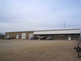
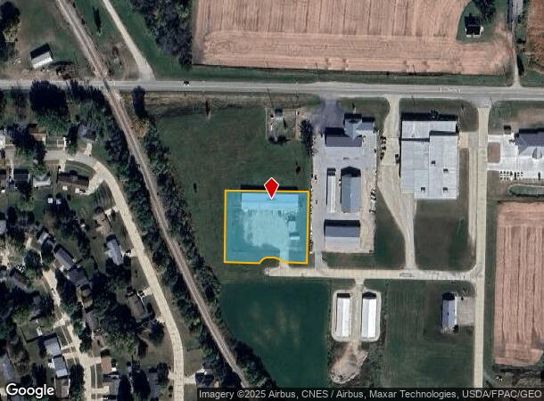
Property Record
2912 Highway 18, Charles City, IA 50616
NEARBY LISTINGS FOR SALE OR LEASE
Property Detail
2912 Highway 18
12-08-103-010-00
East Park Sd
Warehouse
PAR A IN LOT 1EAST PARK SD NW1/4E OF R R 8-95-15
X
Floyd
19067C0210E
Iowa
2025
1
2025
1.38 AC
480500
Iowa Northeast Area
9,000 SF
Other Market Areas
DEMOGRAPHICS near 2912 Highway 18
1 Mile
3 Mile
5 Mile
2024 Total Population
3,004
8,250
9,036
2029 Population
2,945
8,090
8,843
Pop Growth 2024-2029
(1.96%)
(1.94%)
(2.14%)
Average Age
41
43
43
2024 Total Households
1,316
3,664
3,982
HH Growth 2024-2029
(1.98%)
(1.91%)
(2.11%)
Median Household Inc
$52,143
$49,741
$51,541
Avg Household Size
2.20
2.20
2.20
2024 Avg HH Vehicles
2.00
2.00
2.00
Median Home Value
$98,877
$119,872
$124,508
Median Year Built
1958
1959
1959
Nearby Places
Map Layers
Map Styles
 Street
 Aerial
- Restaurants
- Banks
- Shops
- Fitness
- Groceries
Nearby Properties
Address
Land Use
TOTAL SIZE
Lot Size
Zoning
Address
Land Use
TOTAL SIZE
Lot Size
Zoning
79,035 SF
159.54 AC
Address
Land Use
TOTAL SIZE
Lot Size
Zoning
15,600 SF
42.07 AC
Address
Land Use
TOTAL SIZE
Lot Size
Zoning
2,480 SF
34.11 AC
Address
Land Use
TOTAL SIZE
Lot Size
Zoning
66,933 SF
3.16 AC
Address
Land Use
TOTAL SIZE
Lot Size
Zoning
10,800 SF
19.06 AC
Address
Land Use
TOTAL SIZE
Lot Size
Zoning
30,675 SF
0.88 AC
Address
Land Use
TOTAL SIZE
Lot Size
Zoning
5,048 SF
7.44 AC
Address
Land Use
TOTAL SIZE
Lot Size
Zoning
1,586 SF
13.68 AC
Address
Land Use
TOTAL SIZE
Lot Size
Zoning
46,641 SF
1.57 AC
Address
Land Use
TOTAL SIZE
Lot Size
Zoning
40,000 SF
1.98 AC
Address
Land Use
TOTAL SIZE
Lot Size
Zoning
47,028 SF
0.60 AC
Address
Land Use
TOTAL SIZE
Lot Size
Zoning
28,578 SF
3.91 AC
Address
Land Use
TOTAL SIZE
Lot Size
Zoning
Address
Land Use
TOTAL SIZE
Lot Size
Zoning
Address
Land Use
TOTAL SIZE
Lot Size
Zoning
Address
Land Use
TOTAL SIZE
Lot Size
Zoning
Address
Land Use
TOTAL SIZE
Lot Size
Zoning
Address
Land Use
TOTAL SIZE
Lot Size
Zoning
8,554 SF
0.62 AC
Address
Land Use
TOTAL SIZE
Lot Size
Zoning
5,364 SF
4.49 AC
Address
Land Use
TOTAL SIZE
Lot Size
Zoning
14,568 SF
0.80 AC
Address
Land Use
TOTAL SIZE
Lot Size
Zoning
Address
Land Use
TOTAL SIZE
Lot Size
Zoning
29,708 SF
2.89 AC
Address
Land Use
TOTAL SIZE
Lot Size
Zoning
17,493 SF
0.93 AC
Address
Land Use
TOTAL SIZE
Lot Size
Zoning
47,140 SF
11.06 AC
Address
Land Use
TOTAL SIZE
Lot Size
Zoning
7,552 SF
2.98 AC
Address
Land Use
TOTAL SIZE
Lot Size
Zoning
Address
Land Use
TOTAL SIZE
Lot Size
Zoning
24,522 SF
1.20 AC
Address
Land Use
TOTAL SIZE
Lot Size
Zoning
22,016 SF
1.60 AC
Address
Land Use
TOTAL SIZE
Lot Size
Zoning
56,106 SF
6.81 AC
Address
Land Use
TOTAL SIZE
Lot Size
Zoning
17,820 SF
0.75 AC
The World's #1 Commercial Real Estate Marketplace
Connect with us
© 2025 CoStar Group
The information above has been obtained from sources believed reliable. While we do not doubt its accuracy we have not verified it and make no guarantee, warranty or representation about it. It is your responsibility to independently confirm its accuracy and completeness. Any projections, opinions, assumptions, or estimates used are for example only and do not represent the current or future performance of the property. The value of this transaction to you depends on tax and other factors which should be evaluated by your tax, financial, and legal advisors. You and your advisors should conduct a careful, independent investigation of the property to determine to your satisfaction the suitability of the property for your needs.