Property Record
2912 Main Rd, Sheridan, NY 14135
This Property Is For Sale
NEARBY LISTINGS FOR SALE OR LEASE
-
-
View all Sheridan listings for sale on LoopNet.com
Property Detail
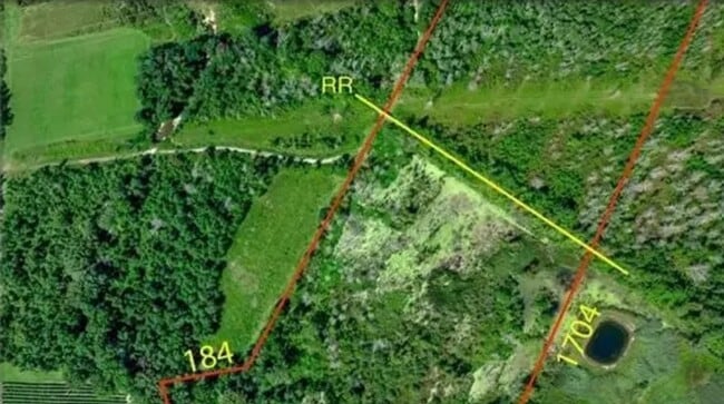
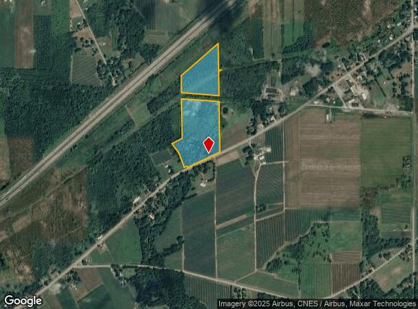
2912 Main Rd
Jamestown-Dunkirk, NY
OLD APN: 066400 6-1-25
066400-081-000-0002-016-000
Chautauqua
Ruralagriculturalresidence
New York
2025
16.000
2024
23.80 AC
035300
New York West Area
1,953 SF
Other Market Areas
DEMOGRAPHICS near 2912 Main Rd
1 mile
3 mile
5 mile
2024 Total Population
286
1,987
19,043
2029 Population
274
1,918
18,315
Pop Growth 2024-2029
(4.20%)
(3.47%)
(3.82%)
Average Age
47
47
41
2024 Total Households
118
849
7,781
HH Growth 2024-2029
(5.08%)
(3.65%)
(4.14%)
Median Household Inc
$64,500
$56,826
$42,950
Avg Household Size
2.30
2.30
2.20
2024 Avg HH Vehicles
2.00
2.00
2.00
Median Home Value
$155,434
$150,488
$88,871
Median Year Built
1957
1959
1949
Nearby Places
Map Layers
Map Styles
 Street
 Aerial
Transit
 Traffic
 Biking
Places
Listings with unknown addresses are not visible on the map
- Restaurants
- Banks
- Shops
- Fitness
- Groceries
PUBLIC TRANSPORTATION
AIRPORT
Buffalo Niagara International
Drive
Walk
Distance
Buffalo Niagara International
66 min
48.1 mi
Nearby Properties
Address
Land Use
TOTAL SIZE
Lot Size
Zoning
Address
Land Use
TOTAL SIZE
Lot Size
Zoning
542,989 SF
47.40 AC
L1
Address
Land Use
TOTAL SIZE
Lot Size
Zoning
23,810 SF
256.60 AC
07 - MIXED
Address
Land Use
TOTAL SIZE
Lot Size
Zoning
121,500 SF
9.30 AC
06 - INDUS
Address
Land Use
TOTAL SIZE
Lot Size
Zoning
142.30 AC
07 - MIXED
Address
Land Use
TOTAL SIZE
Lot Size
Zoning
121,450 SF
9.60 AC
05 - COMME
Address
Land Use
TOTAL SIZE
Lot Size
Zoning
79.90 AC
07 - MIXED
Address
Land Use
TOTAL SIZE
Lot Size
Zoning
76.20 AC
07 - MIXED
Address
Land Use
TOTAL SIZE
Lot Size
Zoning
22,704 SF
5 AC
06 - INDUS
Address
Land Use
TOTAL SIZE
Lot Size
Zoning
2.60 AC
L1
Address
Land Use
TOTAL SIZE
Lot Size
Zoning
69 AC
07 - MIXED
Address
Land Use
TOTAL SIZE
Lot Size
Zoning
21,888 SF
8.50 AC
06 - INDUS
Address
Land Use
TOTAL SIZE
Lot Size
Zoning
780 SF
9 AC
L1
Address
Land Use
TOTAL SIZE
Lot Size
Zoning
62,950 SF
49.20 AC
06 - INDUS
Address
Land Use
TOTAL SIZE
Lot Size
Zoning
65,020 SF
1.80 AC
06 - INDUS
Address
Land Use
TOTAL SIZE
Lot Size
Zoning
8,632 SF
58.20 AC
07 - MIXED
Address
Land Use
TOTAL SIZE
Lot Size
Zoning
2,842 SF
33.90 AC
R2
Address
Land Use
TOTAL SIZE
Lot Size
Zoning
3,332 SF
2.50 AC
07 - MIXED
Address
Land Use
TOTAL SIZE
Lot Size
Zoning
2.40 AC
06 - INDUS
Address
Land Use
TOTAL SIZE
Lot Size
Zoning
2,108 SF
28.70 AC
07 - MIXED
Address
Land Use
TOTAL SIZE
Lot Size
Zoning
3,416 SF
5.20 AC
07 - MIXED
Address
Land Use
TOTAL SIZE
Lot Size
Zoning
16,075 SF
3.90 AC
06 - INDUS
Address
Land Use
TOTAL SIZE
Lot Size
Zoning
1,632 SF
1.40 AC
R2
Address
Land Use
TOTAL SIZE
Lot Size
Zoning
2,048 SF
6 AC
07 - MIXED
Address
Land Use
TOTAL SIZE
Lot Size
Zoning
12,400 SF
1.20 AC
07 - MIXED
Address
Land Use
TOTAL SIZE
Lot Size
Zoning
6,618 SF
81.70 AC
07 - MIXED
Address
Land Use
TOTAL SIZE
Lot Size
Zoning
864 SF
5.10 AC
07 - MIXED
Address
Land Use
TOTAL SIZE
Lot Size
Zoning
3,296 SF
4 AC
07 - MIXED
Address
Land Use
TOTAL SIZE
Lot Size
Zoning
14.20 AC
07
Address
Land Use
TOTAL SIZE
Lot Size
Zoning
2,748 SF
61.40 AC
07 - MIXED
Address
Land Use
TOTAL SIZE
Lot Size
Zoning
7,759 SF
1.16 AC
CR
The World's #1 Commercial Real Estate Marketplace
Connect with us
© 2026 CoStar Group
The information above has been obtained from sources believed reliable. While we do not doubt its accuracy we have not verified it and make no guarantee, warranty or representation about it. It is your responsibility to independently confirm its accuracy and completeness. Any projections, opinions, assumptions, or estimates used are for example only and do not represent the current or future performance of the property. The value of this transaction to you depends on tax and other factors which should be evaluated by your tax, financial, and legal advisors. You and your advisors should conduct a careful, independent investigation of the property to determine to your satisfaction the suitability of the property for your needs.