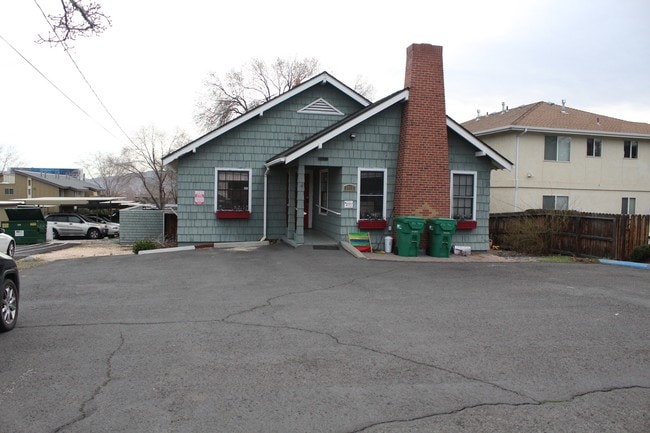
Property Record
2912 Plumas St, Reno, NV 89509

NEARBY LISTINGS FOR SALE OR LEASE
Property Detail
2912 Plumas St
Reno, NV
Warren
019-432-26
Washoe
Duplex
Nevada
X
0.16 AC
32031C3231G
Park Lane
1,182 SF
Reno/Sparks
DEMOGRAPHICS near 2912 Plumas St
1 Mile
3 Mile
5 Mile
2024 Total Population
15,150
97,335
217,635
2029 Population
15,892
102,338
229,250
Pop Growth 2024-2029
+ 4.90%
+ 5.14%
+ 5.34%
Average Age
41
41
39
2024 Total Households
7,135
43,942
92,466
HH Growth 2024-2029
+ 5.05%
+ 5.20%
+ 5.48%
Median Household Inc
$51,017
$59,250
$60,540
Avg Household Size
2.10
2.10
2.20
2024 Avg HH Vehicles
1.00
2.00
2.00
Median Home Value
$589,445
$544,992
$445,063
Median Year Built
1977
1976
1980
Nearby Places
Map Layers
Map Styles
 Street
 Aerial
- Restaurants
- Banks
- Shops
- Fitness
- Groceries
PUBLIC TRANSPORTATION
COMMUTER RAIL
DRIVE
WALK
Distance
7 min
2.6 mi
AIRPORT
Reno/Tahoe International
DRIVE
WALK
Distance
Reno/Tahoe International
25 min
5.9 mi
SALE & LEASE HISTORY
LISTING DATE
SALE/LEASE

Sep 28, 2017
For Sale
Sep 24, 2016
For Sale
Nov 10, 2017
For Sale
Nearby Properties
Address
Land Use
TOTAL SIZE
Lot Size
Zoning
Address
Land Use
TOTAL SIZE
Lot Size
Zoning
2,041,608 SF
28.47 AC
MU
Address
Land Use
TOTAL SIZE
Lot Size
Zoning
1,638,272 SF
17.11 AC
MU
Address
Land Use
TOTAL SIZE
Lot Size
Zoning
762,384 SF
1,131.28 AC
MA
Address
Land Use
TOTAL SIZE
Lot Size
Zoning
1,103,124 SF
138.61 AC
MU
Address
Land Use
TOTAL SIZE
Lot Size
Zoning
799,762 SF
13.30 AC
MU
Address
Land Use
TOTAL SIZE
Lot Size
Zoning
1,865,345 SF
2.75 AC
MD-ED
Address
Land Use
TOTAL SIZE
Lot Size
Zoning
1.47 AC
MD-UD
Address
Land Use
TOTAL SIZE
Lot Size
Zoning
1,048,514 SF
1.30 AC
MU
Address
Land Use
TOTAL SIZE
Lot Size
Zoning
759,161 SF
37.37 AC
MU
Address
Land Use
TOTAL SIZE
Lot Size
Zoning
893,055 SF
52.71 AC
MA
Address
Land Use
TOTAL SIZE
Lot Size
Zoning
497,928 SF
3.52 AC
MU
Address
Land Use
TOTAL SIZE
Lot Size
Zoning
645,699 SF
4.53 AC
MU
Address
Land Use
TOTAL SIZE
Lot Size
Zoning
501,541 SF
2.89 AC
MD-ED
Address
Land Use
TOTAL SIZE
Lot Size
Zoning
500,079 SF
45.66 AC
SPD
Address
Land Use
TOTAL SIZE
Lot Size
Zoning
460,367 SF
1.52 AC
MD-ED
Address
Land Use
TOTAL SIZE
Lot Size
Zoning
189,861 SF
1.69 AC
MD-NWQ
Address
Land Use
TOTAL SIZE
Lot Size
Zoning
232,156 SF
1.76 AC
MU
Address
Land Use
TOTAL SIZE
Lot Size
Zoning
306,626 SF
17.61 AC
MF14 44% /
Address
Land Use
TOTAL SIZE
Lot Size
Zoning
234,478 SF
2.93 AC
MD-ED
Address
Land Use
TOTAL SIZE
Lot Size
Zoning
587,380 SF
2.59 AC
MD-ED
Address
Land Use
TOTAL SIZE
Lot Size
Zoning
257,400 SF
2.71 AC
MD-ED
Address
Land Use
TOTAL SIZE
Lot Size
Zoning
434,002 SF
7.64 AC
MD-NWQ
Address
Land Use
TOTAL SIZE
Lot Size
Zoning
194,000 SF
2.24 AC
MD-RD
Address
Land Use
TOTAL SIZE
Lot Size
Zoning
283,243 SF
2.02 AC
MD-UD
Address
Land Use
TOTAL SIZE
Lot Size
Zoning
109,936 SF
1.80 AC
MD-RD
Address
Land Use
TOTAL SIZE
Lot Size
Zoning
125,324 SF
2.06 AC
MD-NWQ
Address
Land Use
TOTAL SIZE
Lot Size
Zoning
100,469 SF
2.76 AC
MD-ED
Address
Land Use
TOTAL SIZE
Lot Size
Zoning
209,748 SF
3.88 AC
MD-RD
Address
Land Use
TOTAL SIZE
Lot Size
Zoning
231,329 SF
8.37 AC
GC
Address
Land Use
TOTAL SIZE
Lot Size
Zoning
573,331 SF
6.52 AC
MD-ED
The World's #1 Commercial Real Estate Marketplace
Connect with us
© 2025 CoStar Group
The information above has been obtained from sources believed reliable. While we do not doubt its accuracy we have not verified it and make no guarantee, warranty or representation about it. It is your responsibility to independently confirm its accuracy and completeness. Any projections, opinions, assumptions, or estimates used are for example only and do not represent the current or future performance of the property. The value of this transaction to you depends on tax and other factors which should be evaluated by your tax, financial, and legal advisors. You and your advisors should conduct a careful, independent investigation of the property to determine to your satisfaction the suitability of the property for your needs.