Property Record
2912 Wasson Rd, Cincinnati, OH 45209

Save to a Folder
{{folder.Name}}
{{folder.ListingIds.length}} Properties
{{folder.ListingIds.length}} Property
Create a New Folder
Property Detail
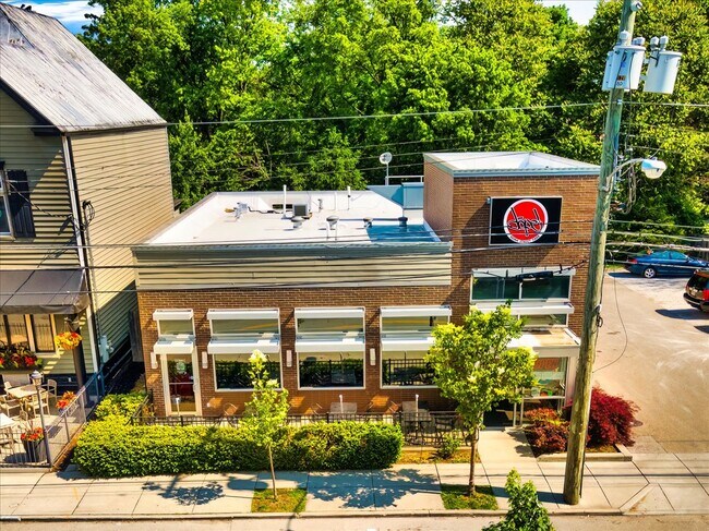
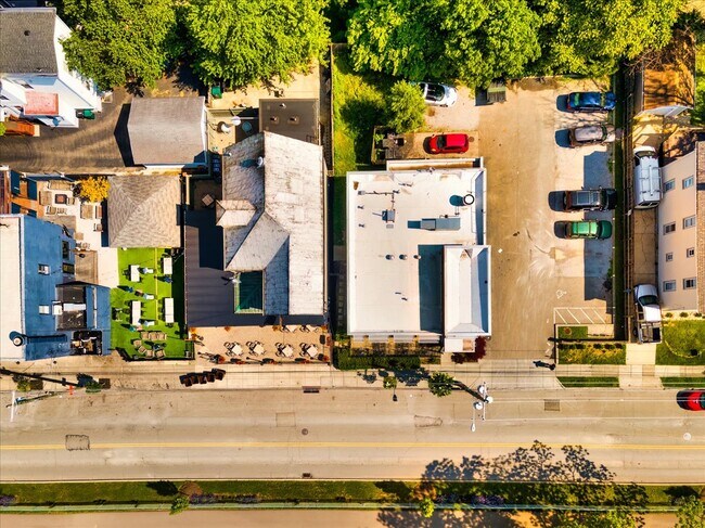
2912 Wasson Rd
039-0005-0145
WASSON RD92 X 100 PT LOTS 104 TH 107F K DRAKES SUBPARS 145 & BK 40PG2 PRS 105-126 CONS
Restaurantbuilding
Hamilton
CNP
Ohio
B and X Area of moderate flood hazard, usually the area between the limits of the 100-year and 500-year floods.
104
2025
0.21 AC
2025
Fairfax/Mt. Lookout
005200
Cincinnati/Dayton
1,656 SF
Cincinnati, OH-KY-IN
NEARBY LISTINGS FOR SALE OR LEASE
DEMOGRAPHICS near 2912 Wasson Rd
1 mile
3 mile
5 mile
2025 Total Population
18,464
109,071
276,557
2030 Population
18,409
110,407
280,846
Pop Growth 2025-2030
(0.30%)
+ 1.22%
+ 1.55%
Average Age
37
38
38
2025 Total Households
9,624
50,837
124,026
HH Growth 2025-2030
(0.36%)
+ 1.20%
+ 1.64%
Median Household Inc
$105,448
$72,206
$67,807
Avg Household Size
1.90
2.00
2.10
2025 Avg HH Vehicles
2.00
2.00
2.00
Median Home Value
$462,215
$329,358
$302,187
Median Year Built
1947
1948
1949
Nearby Places
Map Layers
Map Styles
 Street
 Aerial
Layers
 Traffic
 Biking
Places
Listings with unknown addresses are not visible on the map
- Restaurants
- Banks
- Shops
- Fitness
- Groceries
PUBLIC TRANSPORTATION
COMMUTER RAIL
Cincinnati Union Terminal (Cardinal - Amtrak)
Drive
Walk
Distance
Cincinnati Union Terminal (Cardinal - Amtrak)
15 min
8.7 mi
AIRPORT
Cincinnati/Northern Kentucky International
Drive
Walk
Distance
Cincinnati/Northern Kentucky International
36 min
20.7 mi
Freight Ports
Port of Toledo
Drive
Walk
Distance
Port of Toledo
240 min
203.0 mi
SALE & LEASE HISTORY
LISTING DATE
SALE/LEASE

May 25, 2023
For Sale
Nearby Properties
Address
Land Use
TOTAL SIZE
Lot Size
Zoning
Address
Land Use
TOTAL SIZE
Lot Size
Zoning
62.10 AC
Address
Land Use
TOTAL SIZE
Lot Size
Zoning
13.80 AC
Address
Land Use
TOTAL SIZE
Lot Size
Zoning
Address
Land Use
TOTAL SIZE
Lot Size
Zoning
27.30 AC
M2
Address
Land Use
TOTAL SIZE
Lot Size
Zoning
11.68 AC
Address
Land Use
TOTAL SIZE
Lot Size
Zoning
26,453 SF
19.91 AC
M2
Address
Land Use
TOTAL SIZE
Lot Size
Zoning
148,748 SF
24.90 AC
CGA
Address
Land Use
TOTAL SIZE
Lot Size
Zoning
3.17 AC
R2PUD
Address
Land Use
TOTAL SIZE
Lot Size
Zoning
9.16 AC
Address
Land Use
TOTAL SIZE
Lot Size
Zoning
Address
Land Use
TOTAL SIZE
Lot Size
Zoning
8.05 AC
Address
Land Use
TOTAL SIZE
Lot Size
Zoning
Address
Land Use
TOTAL SIZE
Lot Size
Zoning
5.07 AC
Address
Land Use
TOTAL SIZE
Lot Size
Zoning
Address
Land Use
TOTAL SIZE
Lot Size
Zoning
6.93 AC
MG
Address
Land Use
TOTAL SIZE
Lot Size
Zoning
0.26 AC
RM12
Address
Land Use
TOTAL SIZE
Lot Size
Zoning
Address
Land Use
TOTAL SIZE
Lot Size
Zoning
2,916 SF
27.68 AC
Address
Land Use
TOTAL SIZE
Lot Size
Zoning
3.34 AC
Address
Land Use
TOTAL SIZE
Lot Size
Zoning
83,122 SF
1.99 AC
Address
Land Use
TOTAL SIZE
Lot Size
Zoning
6.91 AC
Address
Land Use
TOTAL SIZE
Lot Size
Zoning
3,864 SF
0.15 AC
PD
Address
Land Use
TOTAL SIZE
Lot Size
Zoning
4.57 AC
Address
Land Use
TOTAL SIZE
Lot Size
Zoning
4,706 SF
18.29 AC
RM20
Address
Land Use
TOTAL SIZE
Lot Size
Zoning
7.06 AC
Address
Land Use
TOTAL SIZE
Lot Size
Zoning
6.80 AC
Address
Land Use
TOTAL SIZE
Lot Size
Zoning
1,152 SF
24.78 AC
B
Address
Land Use
TOTAL SIZE
Lot Size
Zoning
2.17 AC
O
Address
Land Use
TOTAL SIZE
Lot Size
Zoning
18.51 AC
RM20
Address
Land Use
TOTAL SIZE
Lot Size
Zoning
1,187 SF
31.75 AC
ML
The World's #1 Commercial Real Estate Marketplace
Connect with us
© 2026 CoStar Group
The information above has been obtained from sources believed reliable. While we do not doubt its accuracy we have not verified it and make no guarantee, warranty or representation about it. It is your responsibility to independently confirm its accuracy and completeness. Any projections, opinions, assumptions, or estimates used are for example only and do not represent the current or future performance of the property. The value of this transaction to you depends on tax and other factors which should be evaluated by your tax, financial, and legal advisors. You and your advisors should conduct a careful, independent investigation of the property to determine to your satisfaction the suitability of the property for your needs.