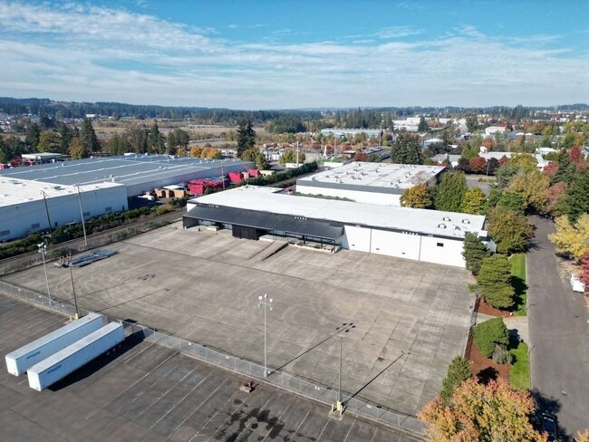
Property Record
29125 Sw Casting St, Wilsonville, OR 97070
Current Lease Availabilities
Property Detail
29125 Sw Casting St
Portland-Vancouver-Hillsboro, OR-WA
1956 WILSONVILLE IND PRK PT LT 1
00812240
Clackamas
Industrialgeneral
Oregon
PDI
1
B and X Area of moderate flood hazard, usually the area between the limits of the 100-year and 500-year floods.
2 AC
2025
Wilsonville
2025
Portland
024402
NEARBY LISTINGS FOR SALE OR LEASE
DEMOGRAPHICS near 29125 Sw Casting St
1 mile
3 mile
5 mile
2025 Total Population
12,076
29,649
68,806
2030 Population
12,184
29,910
69,298
Pop Growth 2025-2030
+ 0.89%
+ 0.88%
+ 0.72%
Average Age
39
41
41
2025 Total Households
4,893
11,711
25,603
HH Growth 2025-2030
+ 0.90%
+ 0.64%
+ 0.64%
Median Household Inc
$98,344
$99,789
$107,513
Avg Household Size
2.40
2.40
2.60
2025 Avg HH Vehicles
2.00
2.00
2.00
Median Home Value
$625,000
$693,094
$685,245
Median Year Built
2003
1997
1993
Nearby Places
Map Layers
Map Styles
 Street
 Aerial
Layers
 Traffic
 Biking
Places
Listings with unknown addresses are not visible on the map
- Restaurants
- Banks
- Shops
- Fitness
- Groceries
PUBLIC TRANSPORTATION
COMMUTER RAIL
Wilsonville (Westside Express Service - Tri-County Metropolitan Transportation District of Oregon Rail (TriMet Rail))
Drive
Walk
Distance
Wilsonville (Westside Express Service - Tri-County Metropolitan Transportation District of Oregon Rail (TriMet Rail))
3 min
6 min
0.3 mi
Tualatin (Westside Express Service - Tri-County Metropolitan Transportation District of Oregon Rail (TriMet Rail))
Drive
Walk
Distance
Tualatin (Westside Express Service - Tri-County Metropolitan Transportation District of Oregon Rail (TriMet Rail))
12 min
5.7 mi
AIRPORT
Portland International
Drive
Walk
Distance
Portland International
45 min
29.8 mi
Freight Ports
Port of Portland
Drive
Walk
Distance
Port of Portland
32 min
21.0 mi
Nearby Properties
Address
Land Use
TOTAL SIZE
Lot Size
Zoning
Address
Land Use
TOTAL SIZE
Lot Size
Zoning
508,000 SF
69.72 AC
PFC
Address
Land Use
TOTAL SIZE
Lot Size
Zoning
20.21 AC
FDAHI
Address
Land Use
TOTAL SIZE
Lot Size
Zoning
9.76 AC
PDI
Address
Land Use
TOTAL SIZE
Lot Size
Zoning
54.36 AC
PDI
Address
Land Use
TOTAL SIZE
Lot Size
Zoning
16.18 AC
PDR4
Address
Land Use
TOTAL SIZE
Lot Size
Zoning
21.25 AC
PDR5
Address
Land Use
TOTAL SIZE
Lot Size
Zoning
Address
Land Use
TOTAL SIZE
Lot Size
Zoning
26.06 AC
PDI
Address
Land Use
TOTAL SIZE
Lot Size
Zoning
24.75 AC
PDI
Address
Land Use
TOTAL SIZE
Lot Size
Zoning
Address
Land Use
TOTAL SIZE
Lot Size
Zoning
18.49 AC
TC
Address
Land Use
TOTAL SIZE
Lot Size
Zoning
24.67 AC
PDR6
Address
Land Use
TOTAL SIZE
Lot Size
Zoning
20.20 AC
PDR6
Address
Land Use
TOTAL SIZE
Lot Size
Zoning
14.44 AC
PDI
Address
Land Use
TOTAL SIZE
Lot Size
Zoning
26.18 AC
PDI
Address
Land Use
TOTAL SIZE
Lot Size
Zoning
87.02 AC
PDI
Address
Land Use
TOTAL SIZE
Lot Size
Zoning
Address
Land Use
TOTAL SIZE
Lot Size
Zoning
14.05 AC
PDR5
Address
Land Use
TOTAL SIZE
Lot Size
Zoning
3,474 SF
23.31 AC
PDI
Address
Land Use
TOTAL SIZE
Lot Size
Zoning
Address
Land Use
TOTAL SIZE
Lot Size
Zoning
9,918 SF
25.16 AC
PDR5
Address
Land Use
TOTAL SIZE
Lot Size
Zoning
20.89 AC
PDR5
Address
Land Use
TOTAL SIZE
Lot Size
Zoning
12.32 AC
PDR5
Address
Land Use
TOTAL SIZE
Lot Size
Zoning
3.41 AC
PDR4
Address
Land Use
TOTAL SIZE
Lot Size
Zoning
20.84 AC
PDI
Address
Land Use
TOTAL SIZE
Lot Size
Zoning
Address
Land Use
TOTAL SIZE
Lot Size
Zoning
14 AC
PDR6
Address
Land Use
TOTAL SIZE
Lot Size
Zoning
Address
Land Use
TOTAL SIZE
Lot Size
Zoning
Address
Land Use
TOTAL SIZE
Lot Size
Zoning
The World's #1 Commercial Real Estate Marketplace
Connect with us
© 2026 CoStar Group
The information above has been obtained from sources believed reliable. While we do not doubt its accuracy we have not verified it and make no guarantee, warranty or representation about it. It is your responsibility to independently confirm its accuracy and completeness. Any projections, opinions, assumptions, or estimates used are for example only and do not represent the current or future performance of the property. The value of this transaction to you depends on tax and other factors which should be evaluated by your tax, financial, and legal advisors. You and your advisors should conduct a careful, independent investigation of the property to determine to your satisfaction the suitability of the property for your needs.