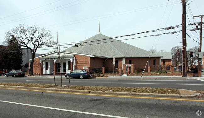
Property Record
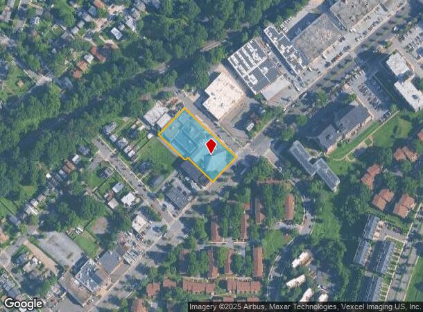
2914 Bladensburg Rd Ne, Washington, DC 20018
NEARBY LISTINGS FOR SALE OR LEASE
Property Detail
2914 Bladensburg Rd Ne
Washington-Arlington-Alexandria, DC-VA-MD-WV
Woodridge
4335-0078
SQUARE 4335 LOT 0078 NBHD: WOODRIDGE
Religious
District of Columbia
X
District of Columbia
24033C0137E
78
0
1.13 AC
2025
Northeast
011100
Washington, DC
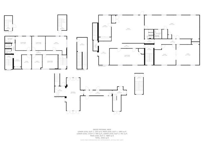
38,698 SF
DEMOGRAPHICS near 2914 Bladensburg Rd Ne
1 Mile
3 Mile
5 Mile
2024 Total Population
17,713
239,531
735,430
2029 Population
16,410
225,282
688,729
Pop Growth 2024-2029
(7.36%)
(5.95%)
(6.35%)
Average Age
40
37
37
2024 Total Households
6,713
97,864
309,167
HH Growth 2024-2029
(8.19%)
(6.62%)
(7.39%)
Median Household Inc
$72,759
$76,838
$86,791
Avg Household Size
2.40
2.30
2.20
2024 Avg HH Vehicles
1.00
1.00
1.00
Median Home Value
$585,294
$526,031
$512,934
Median Year Built
1949
1957
1959
Nearby Places
Map Layers
Map Styles
 Street
 Aerial
- Restaurants
- Banks
- Shops
- Fitness
- Groceries
PUBLIC TRANSPORTATION
COMMUTER RAIL
Riverdale (Camden Line - Maryland Area Regional Commuter Trains (The MARC))
DRIVE
WALK
Distance
Riverdale (Camden Line - Maryland Area Regional Commuter Trains (The MARC))
8 min
3.3 mi
Union Station (Red Line - Washington Metropolitan Area Transit Authority Metrorail (Metrorail))
DRIVE
WALK
Distance
Union Station (Red Line - Washington Metropolitan Area Transit Authority Metrorail (Metrorail))
8 min
3.8 mi
AIRPORT
Ronald Reagan Washington Ntl
DRIVE
WALK
Distance
Ronald Reagan Washington Ntl
19 min
9.4 mi
Baltimore/Washington International Thurgood Marshall
DRIVE
WALK
Distance
Baltimore/Washington International Thurgood Marshall
41 min
27.2 mi
Washington Dulles International
DRIVE
WALK
Distance
Washington Dulles International
53 min
32.0 mi
Freight Ports
Port of Baltimore
DRIVE
WALK
Distance
Port of Baltimore
50 min
33.5 mi
SALE & LEASE HISTORY
LISTING DATE
SALE/LEASE

May 05, 2019
For Lease
Nearby Properties
Address
Land Use
TOTAL SIZE
Lot Size
Zoning
Address
Land Use
TOTAL SIZE
Lot Size
Zoning
58,289 SF
418.97 AC
MU-4;PDR-1
Address
Land Use
TOTAL SIZE
Lot Size
Zoning
1,583,364 SF
276.66 AC
UNZONED
Address
Land Use
TOTAL SIZE
Lot Size
Zoning
1,642,951 SF
95.12 AC
RF-1
Address
Land Use
TOTAL SIZE
Lot Size
Zoning
95.32 AC
RA-1
Address
Land Use
TOTAL SIZE
Lot Size
Zoning
314,995 SF
5.83 AC
D-5
Address
Land Use
TOTAL SIZE
Lot Size
Zoning
21.28 AC
GOV
Address
Land Use
TOTAL SIZE
Lot Size
Zoning
1,835,827 SF
34.66 AC
UNZONED
Address
Land Use
TOTAL SIZE
Lot Size
Zoning
589,000 SF
1.39 AC
D-5
Address
Land Use
TOTAL SIZE
Lot Size
Zoning
791,730 SF
37.44 AC
RA-1
Address
Land Use
TOTAL SIZE
Lot Size
Zoning
823,802 SF
7.30 AC
MU-2
Address
Land Use
TOTAL SIZE
Lot Size
Zoning
2,985,682 SF
4.33 AC
RSF65
Address
Land Use
TOTAL SIZE
Lot Size
Zoning
545,000 SF
0.81 AC
D-5
Address
Land Use
TOTAL SIZE
Lot Size
Zoning
416,764 SF
1.56 AC
D-5
Address
Land Use
TOTAL SIZE
Lot Size
Zoning
538,974 SF
1.26 AC
PDR-3
Address
Land Use
TOTAL SIZE
Lot Size
Zoning
503,872 SF
1.24 AC
D-5
Address
Land Use
TOTAL SIZE
Lot Size
Zoning
755,499 SF
1.75 AC
PDR-3;USN
Address
Land Use
TOTAL SIZE
Lot Size
Zoning
280,000 SF
D-5
Address
Land Use
TOTAL SIZE
Lot Size
Zoning
356,114 SF
2.97 AC
D-5
Address
Land Use
TOTAL SIZE
Lot Size
Zoning
360,000 SF
0.86 AC
D-5
Address
Land Use
TOTAL SIZE
Lot Size
Zoning
407,850 SF
Address
Land Use
TOTAL SIZE
Lot Size
Zoning
346,026 SF
0.79 AC
D-5
Address
Land Use
TOTAL SIZE
Lot Size
Zoning
248,643 SF
8.66 AC
RA-1
Address
Land Use
TOTAL SIZE
Lot Size
Zoning
450,000 SF
1.04 AC
D-5
Address
Land Use
TOTAL SIZE
Lot Size
Zoning
368,602 SF
1.71 AC
MU-4;NMU-5
Address
Land Use
TOTAL SIZE
Lot Size
Zoning
338,258 SF
1.94 AC
PDR-1;PDR-
Address
Land Use
TOTAL SIZE
Lot Size
Zoning
299,722 SF
0.79 AC
D-5
Address
Land Use
TOTAL SIZE
Lot Size
Zoning
281,204 SF
PDR-1;PDR-
Address
Land Use
TOTAL SIZE
Lot Size
Zoning
280,000 SF
1.55 AC
PDR-1
Address
Land Use
TOTAL SIZE
Lot Size
Zoning
376,766 SF
0.93 AC
D-5
Address
Land Use
TOTAL SIZE
Lot Size
Zoning
1,201,133 SF
41.56 AC
RTOHC
The World's #1 Commercial Real Estate Marketplace
Connect with us
© 2025 CoStar Group
The information above has been obtained from sources believed reliable. While we do not doubt its accuracy we have not verified it and make no guarantee, warranty or representation about it. It is your responsibility to independently confirm its accuracy and completeness. Any projections, opinions, assumptions, or estimates used are for example only and do not represent the current or future performance of the property. The value of this transaction to you depends on tax and other factors which should be evaluated by your tax, financial, and legal advisors. You and your advisors should conduct a careful, independent investigation of the property to determine to your satisfaction the suitability of the property for your needs.