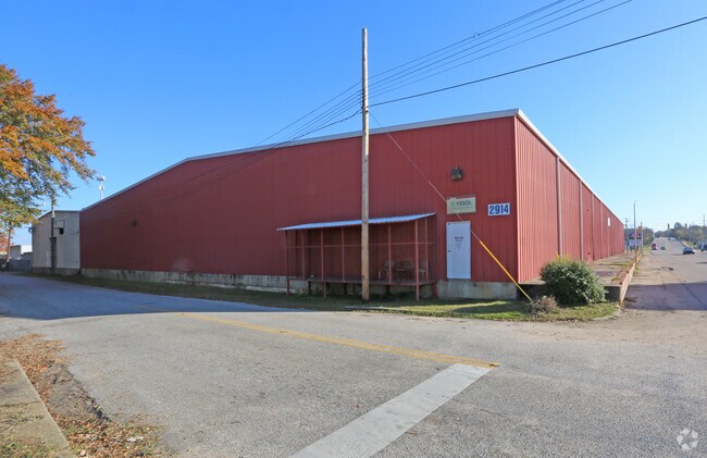
Property Record
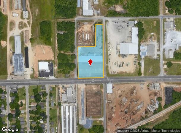
2914 Day St, Montgomery, AL 36108
NEARBY LISTINGS FOR SALE OR LEASE
Property Detail
2914 Day St
11-06-14-2-014-002.000
Irmadale
Publicstorage
SEC 14 T16N R17E 2.7 AC IN NW 1/4 1106142014002000
X
Montgomery
01101C0202J
Alabama
2025
2.74 AC
2025
South Montgomery
001000
Montgomery
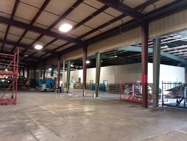
41,700 SF
Montgomery, AL
DEMOGRAPHICS near 2914 Day St
1 Mile
3 Mile
5 Mile
2024 Total Population
5,963
32,775
79,661
2029 Population
6,155
33,536
79,816
Pop Growth 2024-2029
+ 3.22%
+ 2.32%
+ 0.19%
Average Age
36
39
39
2024 Total Households
1,957
12,978
31,838
HH Growth 2024-2029
+ 4.70%
+ 2.88%
+ 0.37%
Median Household Inc
$24,054
$28,029
$33,905
Avg Household Size
2.30
2.10
2.30
2024 Avg HH Vehicles
1.00
1.00
2.00
Median Home Value
$67,331
$77,031
$87,240
Median Year Built
1971
1962
1962
Nearby Places
Map Layers
Map Styles
 Street
 Aerial
- Restaurants
- Banks
- Shops
- Fitness
- Groceries
PUBLIC TRANSPORTATION
AIRPORT
Montgomery Regional (Dannelly Field)
DRIVE
WALK
Distance
Montgomery Regional (Dannelly Field)
25 min
10.7 mi
SALE & LEASE HISTORY
LISTING DATE
SALE/LEASE

Aug 12, 2019
For Lease
Nearby Properties
Address
Land Use
TOTAL SIZE
Lot Size
Zoning
Address
Land Use
TOTAL SIZE
Lot Size
Zoning
800,140 SF
2.27 AC
T5
Address
Land Use
TOTAL SIZE
Lot Size
Zoning
392,741 SF
2.98 AC
T5
Address
Land Use
TOTAL SIZE
Lot Size
Zoning
150,842 SF
5.40 AC
T5
Address
Land Use
TOTAL SIZE
Lot Size
Zoning
193,643 SF
1.61 AC
T5
Address
Land Use
TOTAL SIZE
Lot Size
Zoning
10,844 SF
1.63 AC
Address
Land Use
TOTAL SIZE
Lot Size
Zoning
285,162 SF
M-1
Address
Land Use
TOTAL SIZE
Lot Size
Zoning
107,355 SF
4.12 AC
T5
Address
Land Use
TOTAL SIZE
Lot Size
Zoning
93,981 SF
1.90 AC
T5
Address
Land Use
TOTAL SIZE
Lot Size
Zoning
13,273 SF
2.05 AC
T5
Address
Land Use
TOTAL SIZE
Lot Size
Zoning
58,930 SF
2.24 AC
T5
Address
Land Use
TOTAL SIZE
Lot Size
Zoning
117,175 SF
1.49 AC
T5
Address
Land Use
TOTAL SIZE
Lot Size
Zoning
113,449 SF
0.80 AC
T5
Address
Land Use
TOTAL SIZE
Lot Size
Zoning
77,905 SF
0.83 AC
T5
Address
Land Use
TOTAL SIZE
Lot Size
Zoning
38,226 SF
5.77 AC
T5
Address
Land Use
TOTAL SIZE
Lot Size
Zoning
120,509 SF
0.29 AC
T5
Address
Land Use
TOTAL SIZE
Lot Size
Zoning
1.72 AC
T5
Address
Land Use
TOTAL SIZE
Lot Size
Zoning
22,183 SF
8.38 AC
T5
Address
Land Use
TOTAL SIZE
Lot Size
Zoning
116,707 SF
0.28 AC
T5
Address
Land Use
TOTAL SIZE
Lot Size
Zoning
81,736 SF
0.63 AC
T5
Address
Land Use
TOTAL SIZE
Lot Size
Zoning
3,401 SF
3.21 AC
T5
Address
Land Use
TOTAL SIZE
Lot Size
Zoning
128,328 SF
2.27 AC
T5
Address
Land Use
TOTAL SIZE
Lot Size
Zoning
144,788 SF
0.33 AC
T5
Address
Land Use
TOTAL SIZE
Lot Size
Zoning
65,060 SF
2.16 AC
T4-R
Address
Land Use
TOTAL SIZE
Lot Size
Zoning
0.90 AC
T5
Address
Land Use
TOTAL SIZE
Lot Size
Zoning
145,385 SF
3.31 AC
T4-0
Address
Land Use
TOTAL SIZE
Lot Size
Zoning
40,025 SF
2.48 AC
T5
Address
Land Use
TOTAL SIZE
Lot Size
Zoning
84,003 SF
0.51 AC
T5
Address
Land Use
TOTAL SIZE
Lot Size
Zoning
79,846 SF
14.54 AC
Address
Land Use
TOTAL SIZE
Lot Size
Zoning
64,640 SF
0.52 AC
T5
Address
Land Use
TOTAL SIZE
Lot Size
Zoning
64,117 SF
0.34 AC
T5
The World's #1 Commercial Real Estate Marketplace
Connect with us
© 2025 CoStar Group
The information above has been obtained from sources believed reliable. While we do not doubt its accuracy we have not verified it and make no guarantee, warranty or representation about it. It is your responsibility to independently confirm its accuracy and completeness. Any projections, opinions, assumptions, or estimates used are for example only and do not represent the current or future performance of the property. The value of this transaction to you depends on tax and other factors which should be evaluated by your tax, financial, and legal advisors. You and your advisors should conduct a careful, independent investigation of the property to determine to your satisfaction the suitability of the property for your needs.