Property Record
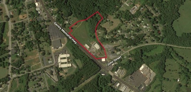
2920 Gentry Memorial Hwy, Pickens, SC 29671
This Property Is For Sale
NEARBY LISTINGS FOR SALE OR LEASE
Property Detail
2920 Gentry Memorial Hwy
4191-17-11-0228
LOT NE/SIDE HWY 8
Warehouse
Pickens
X
South Carolina
45077C0165E
0.22 AC
2025
Outlying Pickens County
2024
Greenville/Spartanburg
010502
Greenville-Anderson-Mauldin, SC
5,600 SF
DEMOGRAPHICS near 2920 Gentry Memorial Hwy
1 Mile
3 Mile
5 Mile
2024 Total Population
2,738
11,085
21,931
2029 Population
2,874
11,593
22,924
Pop Growth 2024-2029
+ 4.97%
+ 4.58%
+ 4.53%
Average Age
41
42
41
2024 Total Households
1,002
4,358
8,595
HH Growth 2024-2029
+ 5.19%
+ 4.68%
+ 4.62%
Median Household Inc
$32,357
$49,840
$44,951
Avg Household Size
2.40
2.40
2.50
2024 Avg HH Vehicles
2.00
2.00
2.00
Median Home Value
$147,305
$171,448
$158,337
Median Year Built
1971
1980
1985
Nearby Places
Map Layers
Map Styles
 Street
 Aerial
- Restaurants
- Banks
- Shops
- Fitness
- Groceries
PUBLIC TRANSPORTATION
AIRPORT
Greenville Spartanburg International
DRIVE
WALK
Distance
Greenville Spartanburg International
55 min
34.6 mi
Freight Ports
North Charleston Terminal
DRIVE
WALK
Distance
North Charleston Terminal
258 min
221.0 mi
Nearby Properties
Address
Land Use
TOTAL SIZE
Lot Size
Zoning
Address
Land Use
TOTAL SIZE
Lot Size
Zoning
56,599 SF
8.02 AC
RM16
Address
Land Use
TOTAL SIZE
Lot Size
Zoning
13,376 SF
12.36 AC
Address
Land Use
TOTAL SIZE
Lot Size
Zoning
29,595 SF
2.94 AC
R12
Address
Land Use
TOTAL SIZE
Lot Size
Zoning
5,356 SF
17.33 AC
Address
Land Use
TOTAL SIZE
Lot Size
Zoning
138.86 AC
GBD
Address
Land Use
TOTAL SIZE
Lot Size
Zoning
12,466 SF
2.32 AC
R12
Address
Land Use
TOTAL SIZE
Lot Size
Zoning
4,829 SF
2 AC
Address
Land Use
TOTAL SIZE
Lot Size
Zoning
5,645 SF
0.67 AC
Address
Land Use
TOTAL SIZE
Lot Size
Zoning
4,080 SF
2.56 AC
GBD
Address
Land Use
TOTAL SIZE
Lot Size
Zoning
6,070 SF
1.71 AC
CBD
Address
Land Use
TOTAL SIZE
Lot Size
Zoning
2,679 SF
0.58 AC
Address
Land Use
TOTAL SIZE
Lot Size
Zoning
19,852 SF
47.45 AC
GBD
Address
Land Use
TOTAL SIZE
Lot Size
Zoning
5,250 SF
1.35 AC
GBD
Address
Land Use
TOTAL SIZE
Lot Size
Zoning
5,468 SF
0.75 AC
CBD
Address
Land Use
TOTAL SIZE
Lot Size
Zoning
114.97 AC
Address
Land Use
TOTAL SIZE
Lot Size
Zoning
4,133 SF
5.15 AC
R12
Address
Land Use
TOTAL SIZE
Lot Size
Zoning
91,940 SF
15.07 AC
GBD
Address
Land Use
TOTAL SIZE
Lot Size
Zoning
20,652 SF
3.89 AC
Address
Land Use
TOTAL SIZE
Lot Size
Zoning
2,434 SF
6.19 AC
Address
Land Use
TOTAL SIZE
Lot Size
Zoning
1,056 SF
34.54 AC
R12
Address
Land Use
TOTAL SIZE
Lot Size
Zoning
3,850 SF
12.40 AC
GBD
Address
Land Use
TOTAL SIZE
Lot Size
Zoning
2,766 SF
0.78 AC
CBD
Address
Land Use
TOTAL SIZE
Lot Size
Zoning
1,296 SF
11.05 AC
Address
Land Use
TOTAL SIZE
Lot Size
Zoning
5,400 SF
2.20 AC
GBD
Address
Land Use
TOTAL SIZE
Lot Size
Zoning
2,997 SF
1.50 AC
GBD
Address
Land Use
TOTAL SIZE
Lot Size
Zoning
4,140 SF
0.06 AC
CBD
Address
Land Use
TOTAL SIZE
Lot Size
Zoning
32,181 SF
2.90 AC
GBD
Address
Land Use
TOTAL SIZE
Lot Size
Zoning
1,716 SF
1.01 AC
GBD
Address
Land Use
TOTAL SIZE
Lot Size
Zoning
1,514 SF
0.34 AC
Address
Land Use
TOTAL SIZE
Lot Size
Zoning
51,730 SF
6.75 AC
RM16
The World's #1 Commercial Real Estate Marketplace
Connect with us
© 2026 CoStar Group
The information above has been obtained from sources believed reliable. While we do not doubt its accuracy we have not verified it and make no guarantee, warranty or representation about it. It is your responsibility to independently confirm its accuracy and completeness. Any projections, opinions, assumptions, or estimates used are for example only and do not represent the current or future performance of the property. The value of this transaction to you depends on tax and other factors which should be evaluated by your tax, financial, and legal advisors. You and your advisors should conduct a careful, independent investigation of the property to determine to your satisfaction the suitability of the property for your needs.