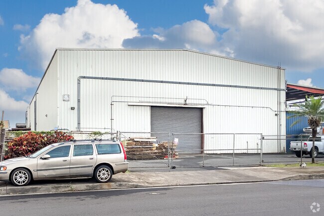
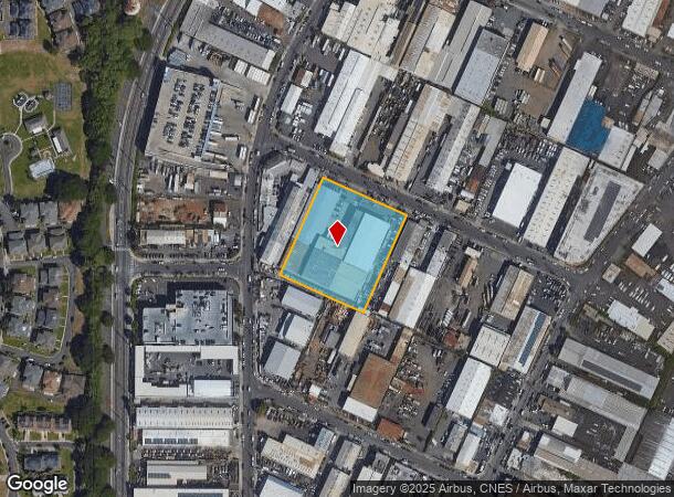
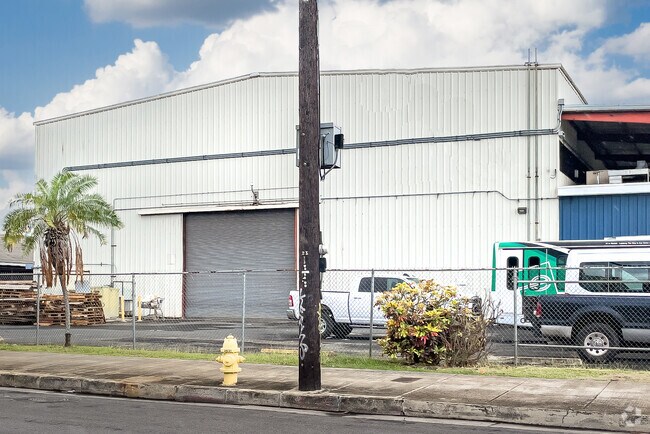
Property Record
2915 Kaihikapu St, Honolulu, HI 96819
NEARBY LISTINGS FOR SALE OR LEASE
Property Detail
2915 Kaihikapu St
1-1-1-005-065-0000
LOT 65, 35,000 SF, LOT 66, 35,000 SF, LOT 67, 35,000 SF, MAP 2, LCCON 42; SUBJ DRN ESMT F MAP 3
Industrialgeneral
Honolulu
AE
Hawaii
15003C0353G
2.41 AC
2024
Leeward
2025
Hawaii
981300
Urban Honolulu, HI
86,028 SF
DEMOGRAPHICS near 2915 Kaihikapu St
1 Mile
3 Mile
5 Mile
2024 Total Population
20,142
133,235
273,270
2029 Population
19,799
128,469
266,757
Pop Growth 2024-2029
(1.70%)
(3.58%)
(2.38%)
Average Age
39
39
42
2024 Total Households
7,526
37,900
98,361
HH Growth 2024-2029
(2.37%)
(4.09%)
(2.53%)
Median Household Inc
$88,088
$82,763
$78,683
Avg Household Size
2.60
3.10
2.50
2024 Avg HH Vehicles
2.00
2.00
1.00
Median Home Value
$497,034
$764,366
$729,604
Median Year Built
1978
1973
1975
Nearby Places
Map Layers
Map Styles
 Street
 Aerial
- Restaurants
- Banks
- Shops
- Fitness
- Groceries
PUBLIC TRANSPORTATION
AIRPORT
Daniel K Inouye International
DRIVE
WALK
Distance
Daniel K Inouye International
8 min
2.4 mi
Freight Ports
Honolulu Harbor, Oahu
DRIVE
WALK
Distance
Honolulu Harbor, Oahu
11 min
4.0 mi
SALE & LEASE HISTORY
LISTING DATE
SALE/LEASE

Dec 16, 2016
For Sale
Nearby Properties
Address
Land Use
TOTAL SIZE
Lot Size
Zoning
Address
Land Use
TOTAL SIZE
Lot Size
Zoning
1,675.63 AC
C/61/60
Address
Land Use
TOTAL SIZE
Lot Size
Zoning
355.21 AC
F-1
Address
Land Use
TOTAL SIZE
Lot Size
Zoning
1,153,381 SF
425.42 AC
R-5
Address
Land Use
TOTAL SIZE
Lot Size
Zoning
1,725,655 SF
11 AC
I-2
Address
Land Use
TOTAL SIZE
Lot Size
Zoning
1,725,655 SF
11 AC
I-2
Address
Land Use
TOTAL SIZE
Lot Size
Zoning
12,430 SF
86.69 AC
I-3
Address
Land Use
TOTAL SIZE
Lot Size
Zoning
163,285 SF
15.08 AC
R-7.5
Address
Land Use
TOTAL SIZE
Lot Size
Zoning
26,537 SF
2,470.86 AC
I-2
Address
Land Use
TOTAL SIZE
Lot Size
Zoning
1,447,909 SF
12.54 AC
IMX-1
Address
Land Use
TOTAL SIZE
Lot Size
Zoning
919,972 SF
14.45 AC
I-2
Address
Land Use
TOTAL SIZE
Lot Size
Zoning
6.20 AC
I-2
Address
Land Use
TOTAL SIZE
Lot Size
Zoning
960 SF
71.97 AC
P-2
Address
Land Use
TOTAL SIZE
Lot Size
Zoning
16.46 AC
I-2
Address
Land Use
TOTAL SIZE
Lot Size
Zoning
40.76 AC
F-1
Address
Land Use
TOTAL SIZE
Lot Size
Zoning
187,487 SF
0.46 AC
BMX-3
Address
Land Use
TOTAL SIZE
Lot Size
Zoning
37.94 AC
I-3
Address
Land Use
TOTAL SIZE
Lot Size
Zoning
267,131 SF
6.06 AC
I-2
Address
Land Use
TOTAL SIZE
Lot Size
Zoning
347,039 SF
12.61 AC
IMX-1
Address
Land Use
TOTAL SIZE
Lot Size
Zoning
619,404 SF
10.83 AC
IMX-1
Address
Land Use
TOTAL SIZE
Lot Size
Zoning
262,068 SF
27.25 AC
I-3
Address
Land Use
TOTAL SIZE
Lot Size
Zoning
12.54 AC
IMX-1
Address
Land Use
TOTAL SIZE
Lot Size
Zoning
350,452 SF
9 AC
IMX-1
Address
Land Use
TOTAL SIZE
Lot Size
Zoning
9.58 AC
IMX-1
Address
Land Use
TOTAL SIZE
Lot Size
Zoning
154,018 SF
15.24 AC
F-1
Address
Land Use
TOTAL SIZE
Lot Size
Zoning
9.46 AC
IMX-1
Address
Land Use
TOTAL SIZE
Lot Size
Zoning
12.47 AC
F-1
Address
Land Use
TOTAL SIZE
Lot Size
Zoning
57,554 SF
10.05 AC
I-2
Address
Land Use
TOTAL SIZE
Lot Size
Zoning
390,709 SF
6.78 AC
IMX-1
Address
Land Use
TOTAL SIZE
Lot Size
Zoning
14,553 SF
14.57 AC
B-2
Address
Land Use
TOTAL SIZE
Lot Size
Zoning
117,641 SF
9.61 AC
B-2
The World's #1 Commercial Real Estate Marketplace
Connect with us
© 2025 CoStar Group
The information above has been obtained from sources believed reliable. While we do not doubt its accuracy we have not verified it and make no guarantee, warranty or representation about it. It is your responsibility to independently confirm its accuracy and completeness. Any projections, opinions, assumptions, or estimates used are for example only and do not represent the current or future performance of the property. The value of this transaction to you depends on tax and other factors which should be evaluated by your tax, financial, and legal advisors. You and your advisors should conduct a careful, independent investigation of the property to determine to your satisfaction the suitability of the property for your needs.